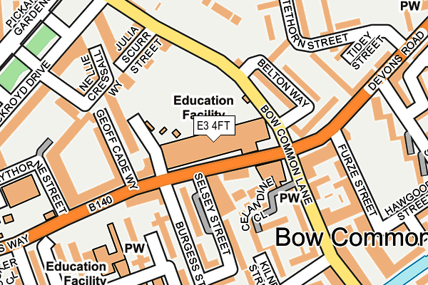
E3 4FT is located in the Mile End electoral ward, within the London borough of Tower Hamlets and the English Parliamentary constituency of Poplar and Limehouse. The Sub Integrated Care Board (ICB) Location is NHS North East London ICB - A3A8R and the police force is Metropolitan Police. This postcode has been in use since January 2011.


GetTheData
Source: OS OpenMap – Local (Ordnance Survey)
Source: OS VectorMap District (Ordnance Survey)
Licence: Open Government Licence (requires attribution)
| Easting | 537155 |
| Northing | 181819 |
| Latitude | 51.518647 |
| Longitude | -0.024622 |
GetTheData
Source: Open Postcode Geo
Licence: Open Government Licence
| Country | England |
| Postcode District | E3 |
➜ See where E3 is on a map ➜ Where is London? | |
GetTheData
Source: Land Registry Price Paid Data
Licence: Open Government Licence
Elevation or altitude of E3 4FT as distance above sea level:
| Metres | Feet | |
|---|---|---|
| Elevation | 10m | 33ft |
Elevation is measured from the approximate centre of the postcode, to the nearest point on an OS contour line from OS Terrain 50, which has contour spacing of ten vertical metres.
➜ How high above sea level am I? Find the elevation of your current position using your device's GPS.
GetTheData
Source: Open Postcode Elevation
Licence: Open Government Licence
| Ward | Mile End |
| Constituency | Poplar And Limehouse |
GetTheData
Source: ONS Postcode Database
Licence: Open Government Licence
| St Paul's Way Trust School | Bow Common | 49m |
| Burgess Street (St Paul's Way) | Bow Common | 72m |
| St Pauls Way Trust School (Bow Common Lane) | Bow Common | 81m |
| St Pauls Way Trust School (Bow Common Lane) | Bow Common | 85m |
| Devons Road (Bow Common Lane) | Bow Common | 106m |
| Devons Road Dlr Station (Devons Road) | Devons Road | 661m |
| Langdon Park Dlr Station (Hay Currie Street) | Poplar | 823m |
| Bow Road Underground Station | Bow | 923m |
| Mile End Underground Station | Mile End | 954m |
| Westferry Dlr Station (Westferry Road) | Westferry | 1,036m |
| Limehouse Station | 1.3km |
| West Ham Station | 2.4km |
| Shadwell Station | 2.4km |
GetTheData
Source: NaPTAN
Licence: Open Government Licence
GetTheData
Source: ONS Postcode Database
Licence: Open Government Licence


➜ Get more ratings from the Food Standards Agency
GetTheData
Source: Food Standards Agency
Licence: FSA terms & conditions
| Last Collection | |||
|---|---|---|---|
| Location | Mon-Fri | Sat | Distance |
| Belton Way | 17:30 | 11:30 | 107m |
| Burdett Road | 17:30 | 11:30 | 304m |
| Thomas Road | 17:30 | 11:30 | 341m |
GetTheData
Source: Dracos
Licence: Creative Commons Attribution-ShareAlike
The below table lists the International Territorial Level (ITL) codes (formerly Nomenclature of Territorial Units for Statistics (NUTS) codes) and Local Administrative Units (LAU) codes for E3 4FT:
| ITL 1 Code | Name |
|---|---|
| TLI | London |
| ITL 2 Code | Name |
| TLI4 | Inner London - East |
| ITL 3 Code | Name |
| TLI42 | Tower Hamlets |
| LAU 1 Code | Name |
| E09000030 | Tower Hamlets |
GetTheData
Source: ONS Postcode Directory
Licence: Open Government Licence
The below table lists the Census Output Area (OA), Lower Layer Super Output Area (LSOA), and Middle Layer Super Output Area (MSOA) for E3 4FT:
| Code | Name | |
|---|---|---|
| OA | E00021488 | |
| LSOA | E01004272 | Tower Hamlets 014D |
| MSOA | E02000877 | Tower Hamlets 014 |
GetTheData
Source: ONS Postcode Directory
Licence: Open Government Licence
| E3 4AD | St Pauls Way | 64m |
| E3 4BA | Belton Way | 108m |
| E14 7AX | Burgess Street | 117m |
| E3 4GD | Bow Common Lane | 120m |
| E14 7AT | Burgess Street | 139m |
| E14 7AY | Celandine Close | 140m |
| E3 3AN | Devons Road | 144m |
| E3 4GJ | Geoff Cade Way | 151m |
| E3 4BB | Belton Way | 151m |
| E14 7AU | Burgess Street | 168m |
GetTheData
Source: Open Postcode Geo; Land Registry Price Paid Data
Licence: Open Government Licence