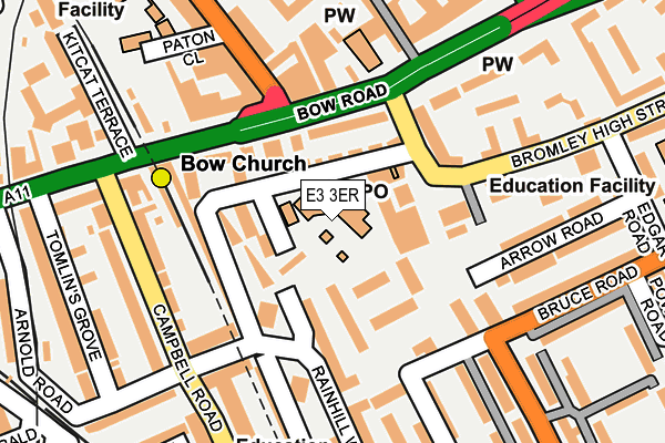
E3 3ER is located in the Bromley North electoral ward, within the London borough of Tower Hamlets and the English Parliamentary constituency of Poplar and Limehouse. The Sub Integrated Care Board (ICB) Location is NHS North East London ICB - A3A8R and the police force is Metropolitan Police. This postcode has been in use since January 1983.


GetTheData
Source: OS OpenMap – Local (Ordnance Survey)
Source: OS VectorMap District (Ordnance Survey)
Licence: Open Government Licence (requires attribution)
| Easting | 537541 |
| Northing | 182797 |
| Latitude | 51.527342 |
| Longitude | -0.018681 |
GetTheData
Source: Open Postcode Geo
Licence: Open Government Licence
| Country | England |
| Postcode District | E3 |
➜ See where E3 is on a map ➜ Where is London? | |
GetTheData
Source: Land Registry Price Paid Data
Licence: Open Government Licence
Elevation or altitude of E3 3ER as distance above sea level:
| Metres | Feet | |
|---|---|---|
| Elevation | 10m | 33ft |
Elevation is measured from the approximate centre of the postcode, to the nearest point on an OS contour line from OS Terrain 50, which has contour spacing of ten vertical metres.
➜ How high above sea level am I? Find the elevation of your current position using your device's GPS.
GetTheData
Source: Open Postcode Elevation
Licence: Open Government Licence
| Ward | Bromley North |
| Constituency | Poplar And Limehouse |
GetTheData
Source: ONS Postcode Database
Licence: Open Government Licence
| Bow Church Dlr (Bow Road) | Bow | 141m |
| Bow Church Dlr (Bow Road) | Bow | 144m |
| Bow Church (Bow Road) | Bow | 149m |
| Bow Bus Garage (Fairfield Road) | Bow | 151m |
| Bow Church (Bow Road) | Bow | 156m |
| Bow Church Dlr Station (Bow Road) | Bow | 167m |
| Bow Road Underground Station | Bow | 450m |
| Devons Road Dlr Station (Devons Road) | Devons Road | 525m |
| Bromley-by-bow Underground Station | Bromley | 569m |
| Pudding Mill Lane Dlr Station (Pudding Mill Lane) | Pudding Mill Lane | 877m |
| West Ham Station | 1.7km |
| Hackney Wick Station | 1.8km |
| Stratford (London) Station | 1.9km |
GetTheData
Source: NaPTAN
Licence: Open Government Licence
GetTheData
Source: ONS Postcode Database
Licence: Open Government Licence


➜ Get more ratings from the Food Standards Agency
GetTheData
Source: Food Standards Agency
Licence: FSA terms & conditions
| Last Collection | |||
|---|---|---|---|
| Location | Mon-Fri | Sat | Distance |
| 2/4 Stroudley Walk E3 | 18:30 | 12:00 | 88m |
| O/S Bow Mspo | 18:30 | 12:00 | 88m |
| Bow Road | 17:30 | 11:30 | 140m |
GetTheData
Source: Dracos
Licence: Creative Commons Attribution-ShareAlike
The below table lists the International Territorial Level (ITL) codes (formerly Nomenclature of Territorial Units for Statistics (NUTS) codes) and Local Administrative Units (LAU) codes for E3 3ER:
| ITL 1 Code | Name |
|---|---|
| TLI | London |
| ITL 2 Code | Name |
| TLI4 | Inner London - East |
| ITL 3 Code | Name |
| TLI42 | Tower Hamlets |
| LAU 1 Code | Name |
| E09000030 | Tower Hamlets |
GetTheData
Source: ONS Postcode Directory
Licence: Open Government Licence
The below table lists the Census Output Area (OA), Lower Layer Super Output Area (LSOA), and Middle Layer Super Output Area (MSOA) for E3 3ER:
| Code | Name | |
|---|---|---|
| OA | E00167264 | |
| LSOA | E01004237 | Tower Hamlets 008C |
| MSOA | E02000871 | Tower Hamlets 008 |
GetTheData
Source: ONS Postcode Directory
Licence: Open Government Licence
| E3 3HG | Stroudley Walk | 50m |
| E3 3EW | Stroudley Walk | 66m |
| E3 3EQ | Rainhill Way | 67m |
| E3 3JD | Rainhill Way | 72m |
| E3 3AY | Rainhill Way | 77m |
| E3 3HQ | Regent Square | 86m |
| E3 3EF | Rainhill Way | 90m |
| E3 3AH | Bow Road | 94m |
| E3 3FQ | Rainhill Way | 102m |
| E3 3HW | Regent Square | 102m |
GetTheData
Source: Open Postcode Geo; Land Registry Price Paid Data
Licence: Open Government Licence