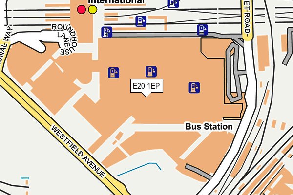
E20 1EP is located in the Stratford Olympic Park electoral ward, within the London borough of Newham and the English Parliamentary constituency of West Ham. The Sub Integrated Care Board (ICB) Location is NHS North East London ICB - A3A8R and the police force is Metropolitan Police. This postcode has been in use since June 2011.


GetTheData
Source: OS OpenMap – Local (Ordnance Survey)
Source: OS VectorMap District (Ordnance Survey)
Licence: Open Government Licence (requires attribution)
| Easting | 538319 |
| Northing | 184588 |
| Latitude | 51.543247 |
| Longitude | -0.006742 |
GetTheData
Source: Open Postcode Geo
Licence: Open Government Licence
| Country | England |
| Postcode District | E20 |
➜ Where is London? | |
GetTheData
Source: Land Registry Price Paid Data
Licence: Open Government Licence
Elevation or altitude of E20 1EP as distance above sea level:
| Metres | Feet | |
|---|---|---|
| Elevation | 10m | 33ft |
Elevation is measured from the approximate centre of the postcode, to the nearest point on an OS contour line from OS Terrain 50, which has contour spacing of ten vertical metres.
➜ How high above sea level am I? Find the elevation of your current position using your device's GPS.
GetTheData
Source: Open Postcode Elevation
Licence: Open Government Licence
| Ward | Stratford Olympic Park |
| Constituency | West Ham |
GetTheData
Source: ONS Postcode Database
Licence: Open Government Licence
| Westfield Avenue | Stratford | 179m |
| Stratford City Bus Station | Stratford New Town | 181m |
| Stratford City Bus Station | Stratford New Town | 197m |
| Stratford City Bus Station | Stratford New Town | 202m |
| Stratford City Bus Station | Stratford New Town | 206m |
| Stratford Underground Station | Stratford | 280m |
| Stratford Dlr Station (Station Street) | Stratford | 293m |
| Stratford International Dlr Station | Stratford | 300m |
| Stratford High Street Dlr Station | Stratford | 687m |
| Pudding Mill Lane Dlr Station (Pudding Mill Lane) | Pudding Mill Lane | 1,078m |
| Stratford International Station | 0.2km |
| Stratford (London) Station | 0.3km |
| Maryland Station | 0.9km |
GetTheData
Source: NaPTAN
Licence: Open Government Licence
| Median download speed | 11.9Mbps |
| Average download speed | 16.8Mbps |
| Maximum download speed | 58.95Mbps |
| Median upload speed | 1.0Mbps |
| Average upload speed | 3.0Mbps |
| Maximum upload speed | 20.00Mbps |
GetTheData
Source: Ofcom
Licence: Ofcom Terms of Use (requires attribution)
GetTheData
Source: ONS Postcode Database
Licence: Open Government Licence


➜ Get more ratings from the Food Standards Agency
GetTheData
Source: Food Standards Agency
Licence: FSA terms & conditions
| Last Collection | |||
|---|---|---|---|
| Location | Mon-Fri | Sat | Distance |
| Windmill Lane | 17:30 | 11:30 | 571m |
| 26/28 Broadway E15 | 17:30 | 12:00 | 600m |
| O/S Stratford Ifpo | 17:30 | 12:00 | 600m |
GetTheData
Source: Dracos
Licence: Creative Commons Attribution-ShareAlike
The below table lists the International Territorial Level (ITL) codes (formerly Nomenclature of Territorial Units for Statistics (NUTS) codes) and Local Administrative Units (LAU) codes for E20 1EP:
| ITL 1 Code | Name |
|---|---|
| TLI | London |
| ITL 2 Code | Name |
| TLI4 | Inner London - East |
| ITL 3 Code | Name |
| TLI41 | Hackney and Newham |
| LAU 1 Code | Name |
| E09000025 | Newham |
GetTheData
Source: ONS Postcode Directory
Licence: Open Government Licence
The below table lists the Census Output Area (OA), Lower Layer Super Output Area (LSOA), and Middle Layer Super Output Area (MSOA) for E20 1EP:
| Code | Name | |
|---|---|---|
| OA | E00175033 | |
| LSOA | E01033583 | Newham 013G |
| MSOA | E02000726 | Newham 013 |
GetTheData
Source: ONS Postcode Directory
Licence: Open Government Licence
| E20 1ET | Montfichet Road | 46m |
| E20 1EN | Montfichet Road | 63m |
| E15 2LZ | Gibbins Road | 430m |
| E15 2HU | Gibbins Road | 473m |
| E15 1BG | Gerry Raffles Square | 491m |
| E15 1BQ | Gerry Raffles Square | 491m |
| E15 1AH | Kennard Road | 503m |
| E15 1DA | Station Street | 514m |
| E15 2JE | Hutchins Close | 515m |
| E15 1AU | Rosher Close | 517m |
GetTheData
Source: Open Postcode Geo; Land Registry Price Paid Data
Licence: Open Government Licence