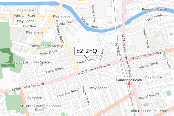
E2 2FQ is located in the St Peter's electoral ward, within the London borough of Tower Hamlets and the English Parliamentary constituency of Bethnal Green and Bow. The Sub Integrated Care Board (ICB) Location is NHS North East London ICB - A3A8R and the police force is Metropolitan Police. This postcode has been in use since June 2019.


GetTheData
Source: OS Open Zoomstack (Ordnance Survey)
Licence: Open Government Licence (requires attribution)
Attribution: Contains OS data © Crown copyright and database right 2025
Source: Open Postcode Geo
Licence: Open Government Licence (requires attribution)
Attribution: Contains OS data © Crown copyright and database right 2025; Contains Royal Mail data © Royal Mail copyright and database right 2025; Source: Office for National Statistics licensed under the Open Government Licence v.3.0
| Easting | 534630 |
| Northing | 183318 |
| Latitude | 51.532726 |
| Longitude | -0.060392 |
GetTheData
Source: Open Postcode Geo
Licence: Open Government Licence
| Country | England |
| Postcode District | E2 |
➜ See where E2 is on a map ➜ Where is Bethnal Green? | |
GetTheData
Source: Land Registry Price Paid Data
Licence: Open Government Licence
| Ward | St Peter's |
| Constituency | Bethnal Green And Bow |
GetTheData
Source: ONS Postcode Database
Licence: Open Government Licence
| Pritchards Road Hackney Road (Hackney Road) | Bethnal Green | 76m |
| Pritchards Road Hackney Road | Bethnal Green | 158m |
| Cambridge Heath Station | Bethnal Green | 165m |
| Cambridge Heath Station | Bethnal Green | 174m |
| Andrews Road | Bethnal Green | 183m |
| Bethnal Green Underground Station | Bethnal Green | 701m |
| Whitechapel Underground Station | Whitechapel | 1,470m |
| Stepney Green Underground Station | Stepney Green | 1,543m |
| Cambridge Heath (London) Station | 0.2km |
| London Fields Station | 1km |
| Bethnal Green Station | 1km |
GetTheData
Source: NaPTAN
Licence: Open Government Licence
GetTheData
Source: ONS Postcode Database
Licence: Open Government Licence


➜ Get more ratings from the Food Standards Agency
GetTheData
Source: Food Standards Agency
Licence: FSA terms & conditions
| Last Collection | |||
|---|---|---|---|
| Location | Mon-Fri | Sat | Distance |
| 481 Cambridge Heath Road E2 | 18:30 | 12:00 | 229m |
| Goldsmith Row | 18:30 | 11:30 | 308m |
| 328 Hackney Road | 17:00 | 11:30 | 325m |
GetTheData
Source: Dracos
Licence: Creative Commons Attribution-ShareAlike
The below table lists the International Territorial Level (ITL) codes (formerly Nomenclature of Territorial Units for Statistics (NUTS) codes) and Local Administrative Units (LAU) codes for E2 2FQ:
| ITL 1 Code | Name |
|---|---|
| TLI | London |
| ITL 2 Code | Name |
| TLI4 | Inner London - East |
| ITL 3 Code | Name |
| TLI42 | Tower Hamlets |
| LAU 1 Code | Name |
| E09000030 | Tower Hamlets |
GetTheData
Source: ONS Postcode Directory
Licence: Open Government Licence
The below table lists the Census Output Area (OA), Lower Layer Super Output Area (LSOA), and Middle Layer Super Output Area (MSOA) for E2 2FQ:
| Code | Name | |
|---|---|---|
| OA | E00167245 | |
| LSOA | E01004202 | Tower Hamlets 005B |
| MSOA | E02000868 | Tower Hamlets 005 |
GetTheData
Source: ONS Postcode Directory
Licence: Open Government Licence
| E2 9DT | The Oval | 90m |
| E2 9BF | Cambridge Crescent | 98m |
| E2 6QL | Hackney Road | 98m |
| E2 6QW | Treadway Street | 107m |
| E2 9ED | Hackney Road | 123m |
| E2 6QB | Tanners Yard | 123m |
| E2 9EG | Hackney Road | 127m |
| E2 9EH | Minerva Street | 129m |
| E2 6GE | Temple Street | 133m |
| E2 9EE | Hackney Road | 134m |
GetTheData
Source: Open Postcode Geo; Land Registry Price Paid Data
Licence: Open Government Licence