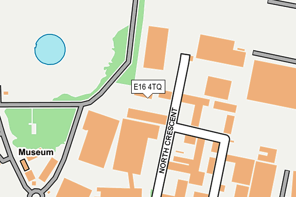
E16 4TQ is located in the Canning Town North electoral ward, within the London borough of Newham and the English Parliamentary constituency of West Ham. The Sub Integrated Care Board (ICB) Location is NHS North East London ICB - A3A8R and the police force is Metropolitan Police. This postcode has been in use since January 1992.


GetTheData
Source: OS OpenMap – Local (Ordnance Survey)
Source: OS VectorMap District (Ordnance Survey)
Licence: Open Government Licence (requires attribution)
| Easting | 538780 |
| Northing | 182412 |
| Latitude | 51.523581 |
| Longitude | -0.000956 |
GetTheData
Source: Open Postcode Geo
Licence: Open Government Licence
| Country | England |
| Postcode District | E16 |
➜ See where E16 is on a map ➜ Where is London? | |
GetTheData
Source: Land Registry Price Paid Data
Licence: Open Government Licence
Elevation or altitude of E16 4TQ as distance above sea level:
| Metres | Feet | |
|---|---|---|
| Elevation | 10m | 33ft |
Elevation is measured from the approximate centre of the postcode, to the nearest point on an OS contour line from OS Terrain 50, which has contour spacing of ten vertical metres.
➜ How high above sea level am I? Find the elevation of your current position using your device's GPS.
GetTheData
Source: Open Postcode Elevation
Licence: Open Government Licence
| Ward | Canning Town North |
| Constituency | West Ham |
GetTheData
Source: ONS Postcode Database
Licence: Open Government Licence
| Prologis Park Bromley-by-bow | Bromley | 294m |
| North Crescent Business Centre (Cody Road) | Canning Town | 298m |
| North Crescent Business Centre (Cody Road) | Canning Town | 298m |
| Prologis Park Bromley-by-bow (Twelvetrees Crescent) | Bromley | 307m |
| Star Lane Station | Canning Town | 411m |
| Star Lane Dlr Station | Canning Town | 473m |
| West Ham Dlr Station | West Ham | 612m |
| West Ham Underground Station | West Ham | 658m |
| Bromley-by-bow Underground Station | Bromley | 746m |
| Abbey Road Dlr Station | Stratford | 984m |
| West Ham Station | 0.7km |
| Stratford (London) Station | 2km |
| Stratford International Station | 2.4km |
GetTheData
Source: NaPTAN
Licence: Open Government Licence
GetTheData
Source: ONS Postcode Database
Licence: Open Government Licence


➜ Get more ratings from the Food Standards Agency
GetTheData
Source: Food Standards Agency
Licence: FSA terms & conditions
| Last Collection | |||
|---|---|---|---|
| Location | Mon-Fri | Sat | Distance |
| Cody Road | 18:30 | 305m | |
| East London Mail Centre | 19:30 | 11:30 | 461m |
| East London Mail Centre | 19:30 | 11:30 | 480m |
GetTheData
Source: Dracos
Licence: Creative Commons Attribution-ShareAlike
The below table lists the International Territorial Level (ITL) codes (formerly Nomenclature of Territorial Units for Statistics (NUTS) codes) and Local Administrative Units (LAU) codes for E16 4TQ:
| ITL 1 Code | Name |
|---|---|
| TLI | London |
| ITL 2 Code | Name |
| TLI4 | Inner London - East |
| ITL 3 Code | Name |
| TLI41 | Hackney and Newham |
| LAU 1 Code | Name |
| E09000025 | Newham |
GetTheData
Source: ONS Postcode Directory
Licence: Open Government Licence
The below table lists the Census Output Area (OA), Lower Layer Super Output Area (LSOA), and Middle Layer Super Output Area (MSOA) for E16 4TQ:
| Code | Name | |
|---|---|---|
| OA | E00017699 | |
| LSOA | E01003500 | Newham 027C |
| MSOA | E02000740 | Newham 027 |
GetTheData
Source: ONS Postcode Directory
Licence: Open Government Licence
| E16 4TG | North Crescent | 89m |
| E3 3JQ | Twelvetrees Crescent | 240m |
| E16 4PT | Daisy Road | 416m |
| E16 4PQ | Damask Crescent | 422m |
| E15 3AN | Manor Road | 443m |
| E15 3AF | Gainsborough Road | 476m |
| E15 3AL | Godbold Road | 508m |
| E15 3AW | Manor Road | 511m |
| E16 4PG | Nutmeg Close | 513m |
| E15 3AD | Milner Road | 515m |
GetTheData
Source: Open Postcode Geo; Land Registry Price Paid Data
Licence: Open Government Licence