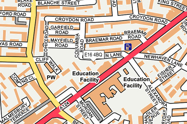
E16 4BQ lies on Newhaven Lane in London. E16 4BQ is located in the Canning Town North electoral ward, within the London borough of Newham and the English Parliamentary constituency of West Ham. The Sub Integrated Care Board (ICB) Location is NHS North East London ICB - A3A8R and the police force is Metropolitan Police. This postcode has been in use since August 2015.


GetTheData
Source: OS OpenMap – Local (Ordnance Survey)
Source: OS VectorMap District (Ordnance Survey)
Licence: Open Government Licence (requires attribution)
| Easting | 539906 |
| Northing | 181987 |
| Latitude | 51.519483 |
| Longitude | 0.015068 |
GetTheData
Source: Open Postcode Geo
Licence: Open Government Licence
| Street | Newhaven Lane |
| Town/City | London |
| Country | England |
| Postcode District | E16 |
➜ See where E16 is on a map ➜ Where is London? | |
GetTheData
Source: Land Registry Price Paid Data
Licence: Open Government Licence
Elevation or altitude of E16 4BQ as distance above sea level:
| Metres | Feet | |
|---|---|---|
| Elevation | 10m | 33ft |
Elevation is measured from the approximate centre of the postcode, to the nearest point on an OS contour line from OS Terrain 50, which has contour spacing of ten vertical metres.
➜ How high above sea level am I? Find the elevation of your current position using your device's GPS.
GetTheData
Source: Open Postcode Elevation
Licence: Open Government Licence
| Ward | Canning Town North |
| Constituency | West Ham |
GetTheData
Source: ONS Postcode Database
Licence: Open Government Licence
| Rokeby School (Barking Road) | Canning Town | 83m |
| Rokeby School (Barking Road) | Canning Town | 94m |
| Hermit Road | Canning Town | 160m |
| Star Lane (Hermit Road) | Canning Town | 170m |
| Star Lane (Hermit Road) | Canning Town | 197m |
| Canning Town Dlr Station (Silvertown Way) | Canning Town | 767m |
| Star Lane Dlr Station | Canning Town | 771m |
| Canning Town Underground Station | Canning Town | 806m |
| Royal Victoria Dlr Station (Victoria Dock Road) | Royal Victoria | 1,154m |
| West Ham Underground Station | West Ham | 1,187m |
| West Ham Station | 1.2km |
| Stratford (London) Station | 2.8km |
| Maryland Station | 3km |
GetTheData
Source: NaPTAN
Licence: Open Government Licence
| Percentage of properties with Next Generation Access | 100.0% |
| Percentage of properties with Superfast Broadband | 100.0% |
| Percentage of properties with Ultrafast Broadband | 0.0% |
| Percentage of properties with Full Fibre Broadband | 0.0% |
Superfast Broadband is between 30Mbps and 300Mbps
Ultrafast Broadband is > 300Mbps
| Percentage of properties unable to receive 2Mbps | 0.0% |
| Percentage of properties unable to receive 5Mbps | 0.0% |
| Percentage of properties unable to receive 10Mbps | 0.0% |
| Percentage of properties unable to receive 30Mbps | 0.0% |
GetTheData
Source: Ofcom
Licence: Ofcom Terms of Use (requires attribution)
GetTheData
Source: ONS Postcode Database
Licence: Open Government Licence


➜ Get more ratings from the Food Standards Agency
GetTheData
Source: Food Standards Agency
Licence: FSA terms & conditions
| Last Collection | |||
|---|---|---|---|
| Location | Mon-Fri | Sat | Distance |
| Hermit Road | 17:30 | 11:30 | 190m |
| Blanche Street | 17:30 | 11:30 | 261m |
| 128a Barking Road | 17:30 | 11:30 | 322m |
GetTheData
Source: Dracos
Licence: Creative Commons Attribution-ShareAlike
| Risk of E16 4BQ flooding from rivers and sea | Very Low |
| ➜ E16 4BQ flood map | |
GetTheData
Source: Open Flood Risk by Postcode
Licence: Open Government Licence
The below table lists the International Territorial Level (ITL) codes (formerly Nomenclature of Territorial Units for Statistics (NUTS) codes) and Local Administrative Units (LAU) codes for E16 4BQ:
| ITL 1 Code | Name |
|---|---|
| TLI | London |
| ITL 2 Code | Name |
| TLI4 | Inner London - East |
| ITL 3 Code | Name |
| TLI41 | Hackney and Newham |
| LAU 1 Code | Name |
| E09000025 | Newham |
GetTheData
Source: ONS Postcode Directory
Licence: Open Government Licence
The below table lists the Census Output Area (OA), Lower Layer Super Output Area (LSOA), and Middle Layer Super Output Area (MSOA) for E16 4BQ:
| Code | Name | |
|---|---|---|
| OA | E00017711 | |
| LSOA | E01003502 | Newham 030C |
| MSOA | E02000743 | Newham 030 |
GetTheData
Source: ONS Postcode Directory
Licence: Open Government Licence
| E16 4HH | Barking Road | 32m |
| E16 4HJ | Newhaven Lane | 52m |
| E16 4QD | Trinity Gardens | 56m |
| E16 4QB | Trinity Gardens | 68m |
| E13 8EH | Braemar Road | 100m |
| E16 4HL | Cliff Walk | 107m |
| E13 8EW | Columbia Road | 115m |
| E13 8EJ | Mayfield Road | 116m |
| E13 8EP | Croydon Road | 134m |
| E13 8EN | Garfield Road | 147m |
GetTheData
Source: Open Postcode Geo; Land Registry Price Paid Data
Licence: Open Government Licence