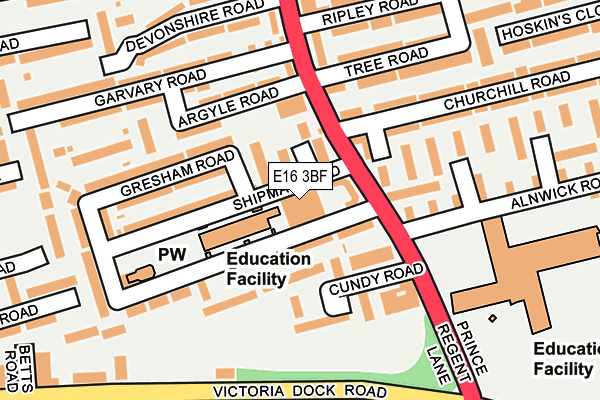
E16 3BF is located in the Custom House electoral ward, within the London borough of Newham and the English Parliamentary constituency of West Ham. The Sub Integrated Care Board (ICB) Location is NHS North East London ICB - A3A8R and the police force is Metropolitan Police. This postcode has been in use since April 2017.


GetTheData
Source: OS OpenMap – Local (Ordnance Survey)
Source: OS VectorMap District (Ordnance Survey)
Licence: Open Government Licence (requires attribution)
| Easting | 541091 |
| Northing | 181149 |
| Latitude | 51.511659 |
| Longitude | 0.031828 |
GetTheData
Source: Open Postcode Geo
Licence: Open Government Licence
| Country | England |
| Postcode District | E16 |
➜ See where E16 is on a map ➜ Where is London? | |
GetTheData
Source: Land Registry Price Paid Data
Licence: Open Government Licence
| Ward | Custom House |
| Constituency | West Ham |
GetTheData
Source: ONS Postcode Database
Licence: Open Government Licence
| Tree Road (Prince Regent Lane) | Custom House | 73m |
| Tree Road | Custom House | 152m |
| Prince Regent Station (Victoria Dock Road) | Prince Regent | 208m |
| Victoria Dock Road | Custom House | 211m |
| Victoria Dock Road | Custom House | 214m |
| Prince Regent Dlr Station (Victoria Dock Road) | Prince Regent | 313m |
| Custom House (For Excel) Dlr Station (Victoria Dock Road) | Custom House | 415m |
| Royal Victoria Dlr Station (Victoria Dock Road) | Royal Victoria | 959m |
| Royal Albert Dlr Station (Road Parallel To Royal Albert Way) | Royal Albert | 1,048m |
| Pontoon Dock Dlr Station (North Woolwich Road) | Silvertown | 1,051m |
| West Ham Station | 2.6km |
| Charlton Station | 2.8km |
| Woolwich Dockyard Station | 2.8km |
GetTheData
Source: NaPTAN
Licence: Open Government Licence
| Percentage of properties with Next Generation Access | 100.0% |
| Percentage of properties with Superfast Broadband | 100.0% |
| Percentage of properties with Ultrafast Broadband | 100.0% |
| Percentage of properties with Full Fibre Broadband | 0.0% |
Superfast Broadband is between 30Mbps and 300Mbps
Ultrafast Broadband is > 300Mbps
| Median download speed | 40.0Mbps |
| Average download speed | 44.8Mbps |
| Maximum download speed | 80.00Mbps |
| Median upload speed | 10.0Mbps |
| Average upload speed | 10.8Mbps |
| Maximum upload speed | 20.00Mbps |
| Percentage of properties unable to receive 2Mbps | 0.0% |
| Percentage of properties unable to receive 5Mbps | 0.0% |
| Percentage of properties unable to receive 10Mbps | 0.0% |
| Percentage of properties unable to receive 30Mbps | 0.0% |
GetTheData
Source: Ofcom
Licence: Ofcom Terms of Use (requires attribution)
GetTheData
Source: ONS Postcode Database
Licence: Open Government Licence


➜ Get more ratings from the Food Standards Agency
GetTheData
Source: Food Standards Agency
Licence: FSA terms & conditions
| Last Collection | |||
|---|---|---|---|
| Location | Mon-Fri | Sat | Distance |
| 11 Cundy Road E16 | 17:30 | 11:30 | 103m |
| Otley Road | 17:30 | 11:30 | 292m |
| Young Road | 17:30 | 11:30 | 328m |
GetTheData
Source: Dracos
Licence: Creative Commons Attribution-ShareAlike
| Risk of E16 3BF flooding from rivers and sea | Low |
| ➜ E16 3BF flood map | |
GetTheData
Source: Open Flood Risk by Postcode
Licence: Open Government Licence
The below table lists the International Territorial Level (ITL) codes (formerly Nomenclature of Territorial Units for Statistics (NUTS) codes) and Local Administrative Units (LAU) codes for E16 3BF:
| ITL 1 Code | Name |
|---|---|
| TLI | London |
| ITL 2 Code | Name |
| TLI4 | Inner London - East |
| ITL 3 Code | Name |
| TLI41 | Hackney and Newham |
| LAU 1 Code | Name |
| E09000025 | Newham |
GetTheData
Source: ONS Postcode Directory
Licence: Open Government Licence
The below table lists the Census Output Area (OA), Lower Layer Super Output Area (LSOA), and Middle Layer Super Output Area (MSOA) for E16 3BF:
| Code | Name | |
|---|---|---|
| OA | E00017769 | |
| LSOA | E01003515 | Newham 036D |
| MSOA | E02000749 | Newham 036 |
GetTheData
Source: ONS Postcode Directory
Licence: Open Government Licence
| E16 3DT | Shipman Road | 66m |
| E16 3DJ | Cundy Road | 76m |
| E16 3DA | Fortis Close | 86m |
| E16 3HX | Prince Regent Lane | 105m |
| E16 3DS | Berwick Road | 116m |
| E16 3DL | Cundy Road | 123m |
| E16 3NF | Argyle Road | 125m |
| E16 3NE | Argyle Road | 135m |
| E16 3DU | Gresham Road | 146m |
| E16 3DZ | Tree Road | 165m |
GetTheData
Source: Open Postcode Geo; Land Registry Price Paid Data
Licence: Open Government Licence