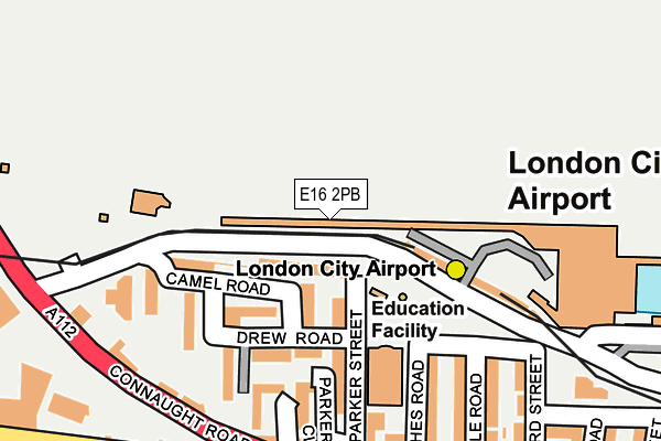
E16 2PB is located in the Royal Albert electoral ward, within the London borough of Newham and the English Parliamentary constituency of East Ham. The Sub Integrated Care Board (ICB) Location is NHS North East London ICB - A3A8R and the police force is Metropolitan Police. This postcode has been in use since June 2000.


GetTheData
Source: OS OpenMap – Local (Ordnance Survey)
Source: OS VectorMap District (Ordnance Survey)
Licence: Open Government Licence (requires attribution)
| Easting | 542128 |
| Northing | 180342 |
| Latitude | 51.504147 |
| Longitude | 0.046409 |
GetTheData
Source: Open Postcode Geo
Licence: Open Government Licence
| Country | England |
| Postcode District | E16 |
➜ See where E16 is on a map ➜ Where is London? | |
GetTheData
Source: Land Registry Price Paid Data
Licence: Open Government Licence
Elevation or altitude of E16 2PB as distance above sea level:
| Metres | Feet | |
|---|---|---|
| Elevation | 10m | 33ft |
Elevation is measured from the approximate centre of the postcode, to the nearest point on an OS contour line from OS Terrain 50, which has contour spacing of ten vertical metres.
➜ How high above sea level am I? Find the elevation of your current position using your device's GPS.
GetTheData
Source: Open Postcode Elevation
Licence: Open Government Licence
| Ward | Royal Albert |
| Constituency | East Ham |
GetTheData
Source: ONS Postcode Database
Licence: Open Government Licence
| Constance Street (Connaught Road) | Silvertown | 219m |
| Constance Street | Silvertown | 223m |
| Saville Road | Silvertown | 271m |
| Saville Road (Albert Road) | Silvertown | 293m |
| London City Airport | Silvertown | 312m |
| London City Airport Dlr Station (Hartmann Road) | Silvertown | 181m |
| Royal Albert Dlr Station (Road Parallel To Royal Albert Way) | Royal Albert | 469m |
| Beckton Park Dlr Station (Royal Albert Way) | Beckton Park | 786m |
| Pontoon Dock Dlr Station (North Woolwich Road) | Silvertown | 1,016m |
| Prince Regent Dlr Station (Victoria Dock Road) | Prince Regent | 1,023m |
| Woolwich Dockyard Station | 1.6km |
| Charlton Station | 2.2km |
| Woolwich Arsenal Station | 2.2km |
GetTheData
Source: NaPTAN
Licence: Open Government Licence
GetTheData
Source: ONS Postcode Database
Licence: Open Government Licence


➜ Get more ratings from the Food Standards Agency
GetTheData
Source: Food Standards Agency
Licence: FSA terms & conditions
| Last Collection | |||
|---|---|---|---|
| Location | Mon-Fri | Sat | Distance |
| O/S 4 Albert Road | 17:30 | 11:30 | 206m |
| Thames Road | 533m | ||
| Jasper Road | 17:30 | 11:30 | 843m |
GetTheData
Source: Dracos
Licence: Creative Commons Attribution-ShareAlike
| Risk of E16 2PB flooding from rivers and sea | Very Low |
| ➜ E16 2PB flood map | |
GetTheData
Source: Open Flood Risk by Postcode
Licence: Open Government Licence
The below table lists the International Territorial Level (ITL) codes (formerly Nomenclature of Territorial Units for Statistics (NUTS) codes) and Local Administrative Units (LAU) codes for E16 2PB:
| ITL 1 Code | Name |
|---|---|
| TLI | London |
| ITL 2 Code | Name |
| TLI4 | Inner London - East |
| ITL 3 Code | Name |
| TLI41 | Hackney and Newham |
| LAU 1 Code | Name |
| E09000025 | Newham |
GetTheData
Source: ONS Postcode Directory
Licence: Open Government Licence
The below table lists the Census Output Area (OA), Lower Layer Super Output Area (LSOA), and Middle Layer Super Output Area (MSOA) for E16 2PB:
| Code | Name | |
|---|---|---|
| OA | E00174999 | |
| LSOA | E01033581 | Newham 037G |
| MSOA | E02000750 | Newham 037 |
GetTheData
Source: ONS Postcode Directory
Licence: Open Government Licence
| E16 2DE | Camel Road | 82m |
| E16 2DD | Camel Road | 125m |
| E16 2DJ | Parker Street | 133m |
| E16 2DG | Drew Road | 139m |
| E16 2DF | Drew Road | 164m |
| E16 2DH | Parker Close | 171m |
| E16 2DQ | Constance Street | 176m |
| E16 2DN | Wythes Road | 189m |
| E16 2AD | Connaught Road | 209m |
| E16 2DW | Albert Road | 219m |
GetTheData
Source: Open Postcode Geo; Land Registry Price Paid Data
Licence: Open Government Licence