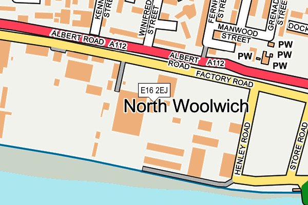
E16 2EJ lies on Standard Industrial Estate in London. E16 2EJ is located in the Royal Albert electoral ward, within the London borough of Newham and the English Parliamentary constituency of East Ham. The Sub Integrated Care Board (ICB) Location is NHS North East London ICB - A3A8R and the police force is Metropolitan Police. This postcode has been in use since July 1983.


GetTheData
Source: OS OpenMap – Local (Ordnance Survey)
Source: OS VectorMap District (Ordnance Survey)
Licence: Open Government Licence (requires attribution)
| Easting | 542795 |
| Northing | 179932 |
| Latitude | 51.500295 |
| Longitude | 0.055874 |
GetTheData
Source: Open Postcode Geo
Licence: Open Government Licence
| Street | Standard Industrial Estate |
| Town/City | London |
| Country | England |
| Postcode District | E16 |
➜ See where E16 is on a map ➜ Where is Woolwich? | |
GetTheData
Source: Land Registry Price Paid Data
Licence: Open Government Licence
Elevation or altitude of E16 2EJ as distance above sea level:
| Metres | Feet | |
|---|---|---|
| Elevation | 0m | 0ft |
Elevation is measured from the approximate centre of the postcode, to the nearest point on an OS contour line from OS Terrain 50, which has contour spacing of ten vertical metres.
➜ How high above sea level am I? Find the elevation of your current position using your device's GPS.
GetTheData
Source: Open Postcode Elevation
Licence: Open Government Licence
| Ward | Royal Albert |
| Constituency | East Ham |
GetTheData
Source: ONS Postcode Database
Licence: Open Government Licence
| Fernhill Street (Albert Road) | North Woolwich | 88m |
| Fernhill Street (Albert Road) | North Woolwich | 146m |
| Kennard Street | North Woolwich | 193m |
| Kennard Street (Albert Road) | North Woolwich | 201m |
| St Johns Church | North Woolwich | 277m |
| King George V Dlr Station (Rymill Street) | Silvertown | 507m |
| London City Airport Dlr Station (Hartmann Road) | Silvertown | 603m |
| Beckton Park Dlr Station (Royal Albert Way) | Beckton Park | 947m |
| Cyprus Dlr Station (Royal Albert Way) | Cyprus | 1,069m |
| Royal Albert Dlr Station (Road Parallel To Royal Albert Way) | Royal Albert | 1,130m |
| Woolwich Dockyard Station | 1km |
| Woolwich Arsenal Station | 1.5km |
| Charlton Station | 2.3km |
GetTheData
Source: NaPTAN
Licence: Open Government Licence
GetTheData
Source: ONS Postcode Database
Licence: Open Government Licence


➜ Get more ratings from the Food Standards Agency
GetTheData
Source: Food Standards Agency
Licence: FSA terms & conditions
| Last Collection | |||
|---|---|---|---|
| Location | Mon-Fri | Sat | Distance |
| 9/10 Pier Parade | 17:30 | 12:00 | 514m |
| O/S 4 Albert Road | 17:30 | 11:30 | 722m |
| Woolwich Dockyard | 17:30 | 12:00 | 781m |
GetTheData
Source: Dracos
Licence: Creative Commons Attribution-ShareAlike
| Risk of E16 2EJ flooding from rivers and sea | Very Low |
| ➜ E16 2EJ flood map | |
GetTheData
Source: Open Flood Risk by Postcode
Licence: Open Government Licence
The below table lists the International Territorial Level (ITL) codes (formerly Nomenclature of Territorial Units for Statistics (NUTS) codes) and Local Administrative Units (LAU) codes for E16 2EJ:
| ITL 1 Code | Name |
|---|---|
| TLI | London |
| ITL 2 Code | Name |
| TLI4 | Inner London - East |
| ITL 3 Code | Name |
| TLI41 | Hackney and Newham |
| LAU 1 Code | Name |
| E09000025 | Newham |
GetTheData
Source: ONS Postcode Directory
Licence: Open Government Licence
The below table lists the Census Output Area (OA), Lower Layer Super Output Area (LSOA), and Middle Layer Super Output Area (MSOA) for E16 2EJ:
| Code | Name | |
|---|---|---|
| OA | E00174964 | |
| LSOA | E01003609 | Newham 037A |
| MSOA | E02000750 | Newham 037 |
GetTheData
Source: ONS Postcode Directory
Licence: Open Government Licence
| E16 2HX | Winifred Street | 162m |
| E16 2LA | Manwood Street | 163m |
| E16 2LB | Manwood Street | 163m |
| E16 2HZ | Fernhill Street | 170m |
| E16 2HT | Sheldrake Close | 179m |
| E16 2JB | Albert Road | 180m |
| E16 2HR | Kennard Street | 199m |
| E16 2FB | Kennard Street | 202m |
| E16 2JZ | Silverland Street | 234m |
| E16 2JR | Rawsthorne Close | 241m |
GetTheData
Source: Open Postcode Geo; Land Registry Price Paid Data
Licence: Open Government Licence