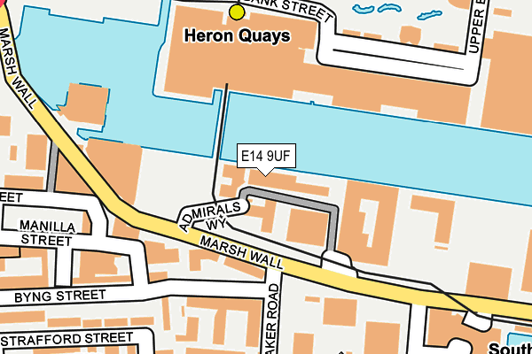
E14 9UF lies on Admirals Way in London. E14 9UF is located in the Canary Wharf electoral ward, within the London borough of Tower Hamlets and the English Parliamentary constituency of Poplar and Limehouse. The Sub Integrated Care Board (ICB) Location is NHS North East London ICB - A3A8R and the police force is Metropolitan Police. This postcode has been in use since July 1986.


GetTheData
Source: OS OpenMap – Local (Ordnance Survey)
Source: OS VectorMap District (Ordnance Survey)
Licence: Open Government Licence (requires attribution)
| Easting | 537458 |
| Northing | 179937 |
| Latitude | 51.501662 |
| Longitude | -0.020991 |
GetTheData
Source: Open Postcode Geo
Licence: Open Government Licence
| Street | Admirals Way |
| Town/City | London |
| Country | England |
| Postcode District | E14 |
➜ See where E14 is on a map ➜ Where is London? | |
GetTheData
Source: Land Registry Price Paid Data
Licence: Open Government Licence
Elevation or altitude of E14 9UF as distance above sea level:
| Metres | Feet | |
|---|---|---|
| Elevation | 10m | 33ft |
Elevation is measured from the approximate centre of the postcode, to the nearest point on an OS contour line from OS Terrain 50, which has contour spacing of ten vertical metres.
➜ How high above sea level am I? Find the elevation of your current position using your device's GPS.
GetTheData
Source: Open Postcode Elevation
Licence: Open Government Licence
| Ward | Canary Wharf |
| Constituency | Poplar And Limehouse |
GetTheData
Source: ONS Postcode Database
Licence: Open Government Licence
| Mastmakers Road (Marsh Wall) | South Quay | 92m |
| Mastmakers Road (Marsh Wall) | South Quay | 116m |
| Admirals Way (Marsh Wall) | South Quay | 129m |
| Canary Wharf Station | Heron Quays | 146m |
| Admirals Way (Marsh Wall) | South Quay | 148m |
| Heron Quays Dlr Station (Heron Quay) | Heron Quays | 193m |
| Canary Wharf Underground Station | Canary Wharf | 278m |
| Canary Wharf Dlr Station (South Colonnade) | Canary Wharf | 353m |
| South Quay Dlr Station (Marsh Wall) | South Quay | 382m |
| West India Quay Dlr Station (West India Quay) | West India Quay | 599m |
| Limehouse Station | 1.8km |
| Canada Water Station | 2km |
| Surrey Quays Station | 2.1km |
GetTheData
Source: NaPTAN
Licence: Open Government Licence
| Median download speed | 6.4Mbps |
| Average download speed | 6.4Mbps |
| Maximum download speed | 12.55Mbps |
| Median upload speed | 1.3Mbps |
| Average upload speed | 1.3Mbps |
| Maximum upload speed | 1.51Mbps |
GetTheData
Source: Ofcom
Licence: Ofcom Terms of Use (requires attribution)
Estimated total energy consumption in E14 9UF by fuel type, 2015.
| Consumption (kWh) | 30,304 |
|---|---|
| Meter count | 7 |
| Mean (kWh/meter) | 4,329 |
| Median (kWh/meter) | 1,996 |
GetTheData
Source: Postcode level gas estimates: 2015 (experimental)
Source: Postcode level electricity estimates: 2015 (experimental)
Licence: Open Government Licence
GetTheData
Source: ONS Postcode Database
Licence: Open Government Licence


➜ Get more ratings from the Food Standards Agency
GetTheData
Source: Food Standards Agency
Licence: FSA terms & conditions
| Last Collection | |||
|---|---|---|---|
| Location | Mon-Fri | Sat | Distance |
| Marsh Wall | 158m | ||
| Bank Street | 19:00 | 11:30 | 207m |
| Canary Wharf Tower | 19:00 | 12:00 | 219m |
GetTheData
Source: Dracos
Licence: Creative Commons Attribution-ShareAlike
| Risk of E14 9UF flooding from rivers and sea | Very Low |
| ➜ E14 9UF flood map | |
GetTheData
Source: Open Flood Risk by Postcode
Licence: Open Government Licence
The below table lists the International Territorial Level (ITL) codes (formerly Nomenclature of Territorial Units for Statistics (NUTS) codes) and Local Administrative Units (LAU) codes for E14 9UF:
| ITL 1 Code | Name |
|---|---|
| TLI | London |
| ITL 2 Code | Name |
| TLI4 | Inner London - East |
| ITL 3 Code | Name |
| TLI42 | Tower Hamlets |
| LAU 1 Code | Name |
| E09000030 | Tower Hamlets |
GetTheData
Source: ONS Postcode Directory
Licence: Open Government Licence
The below table lists the Census Output Area (OA), Lower Layer Super Output Area (LSOA), and Middle Layer Super Output Area (MSOA) for E14 9UF:
| Code | Name | |
|---|---|---|
| OA | E00167122 | |
| LSOA | E01032771 | Tower Hamlets 033B |
| MSOA | E02006854 | Tower Hamlets 033 |
GetTheData
Source: ONS Postcode Directory
Licence: Open Government Licence
| E14 9UD | Admirals Way | 16m |
| E14 9UG | Admirals Way | 16m |
| E14 9XQ | Admirals Way | 41m |
| E14 9UH | Admirals Way | 41m |
| E14 9XG | Admirals Way | 49m |
| E14 9SN | Admirals Way | 66m |
| E14 9XL | Admirals Way | 72m |
| E14 9TP | Marsh Wall | 105m |
| E14 9SP | Admirals Way | 123m |
| E14 9LT | South Quay Square | 137m |
GetTheData
Source: Open Postcode Geo; Land Registry Price Paid Data
Licence: Open Government Licence