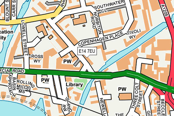
E14 7EU lies on Copenhagen Place in London. E14 7EU is located in the Mile End electoral ward, within the London borough of Tower Hamlets and the English Parliamentary constituency of Poplar and Limehouse. The Sub Integrated Care Board (ICB) Location is NHS North East London ICB - A3A8R and the police force is Metropolitan Police. This postcode has been in use since January 1980.


GetTheData
Source: OS OpenMap – Local (Ordnance Survey)
Source: OS VectorMap District (Ordnance Survey)
Licence: Open Government Licence (requires attribution)
| Easting | 536650 |
| Northing | 181165 |
| Latitude | 51.512892 |
| Longitude | -0.032149 |
GetTheData
Source: Open Postcode Geo
Licence: Open Government Licence
| Street | Copenhagen Place |
| Town/City | London |
| Country | England |
| Postcode District | E14 |
➜ See where E14 is on a map ➜ Where is London? | |
GetTheData
Source: Land Registry Price Paid Data
Licence: Open Government Licence
Elevation or altitude of E14 7EU as distance above sea level:
| Metres | Feet | |
|---|---|---|
| Elevation | 10m | 33ft |
Elevation is measured from the approximate centre of the postcode, to the nearest point on an OS contour line from OS Terrain 50, which has contour spacing of ten vertical metres.
➜ How high above sea level am I? Find the elevation of your current position using your device's GPS.
GetTheData
Source: Open Postcode Elevation
Licence: Open Government Licence
| Ward | Mile End |
| Constituency | Poplar And Limehouse |
GetTheData
Source: ONS Postcode Database
Licence: Open Government Licence
| Salmon Lane | Limehouse | 59m |
| Limehouse Town Hall | Limehouse | 103m |
| Burdett Road (Commercial Road) | Limehouse | 157m |
| Lowell Street | Limehouse | 160m |
| Lowell Street | Limehouse | 181m |
| Limehouse Dlr Station (Commercial Road) | Limehouse | 535m |
| Westferry Dlr Station (Westferry Road) | Westferry | 537m |
| West India Quay Dlr Station (West India Quay) | West India Quay | 1,049m |
| Poplar Dlr Station (Castor Lane) | Poplar | 1,174m |
| Canary Wharf Dlr Station (South Colonnade) | Canary Wharf | 1,184m |
| Limehouse Station | 0.5km |
| Shadwell Station | 1.7km |
| Wapping Station | 1.9km |
GetTheData
Source: NaPTAN
Licence: Open Government Licence
| Percentage of properties with Next Generation Access | 100.0% |
| Percentage of properties with Superfast Broadband | 100.0% |
| Percentage of properties with Ultrafast Broadband | 100.0% |
| Percentage of properties with Full Fibre Broadband | 0.0% |
Superfast Broadband is between 30Mbps and 300Mbps
Ultrafast Broadband is > 300Mbps
| Median download speed | 40.0Mbps |
| Average download speed | 49.2Mbps |
| Maximum download speed | 100.00Mbps |
| Median upload speed | 9.8Mbps |
| Average upload speed | 9.4Mbps |
| Maximum upload speed | 20.00Mbps |
| Percentage of properties unable to receive 2Mbps | 0.0% |
| Percentage of properties unable to receive 5Mbps | 0.0% |
| Percentage of properties unable to receive 10Mbps | 0.0% |
| Percentage of properties unable to receive 30Mbps | 0.0% |
GetTheData
Source: Ofcom
Licence: Ofcom Terms of Use (requires attribution)
Estimated total energy consumption in E14 7EU by fuel type, 2015.
| Consumption (kWh) | 56,493 |
|---|---|
| Meter count | 18 |
| Mean (kWh/meter) | 3,138 |
| Median (kWh/meter) | 943 |
| Consumption (kWh) | 87,817 |
|---|---|
| Meter count | 22 |
| Mean (kWh/meter) | 3,992 |
| Median (kWh/meter) | 3,205 |
GetTheData
Source: Postcode level gas estimates: 2015 (experimental)
Source: Postcode level electricity estimates: 2015 (experimental)
Licence: Open Government Licence
GetTheData
Source: ONS Postcode Database
Licence: Open Government Licence


➜ Get more ratings from the Food Standards Agency
GetTheData
Source: Food Standards Agency
Licence: FSA terms & conditions
| Last Collection | |||
|---|---|---|---|
| Location | Mon-Fri | Sat | Distance |
| 127 Salmon Lane E14 | 17:30 | 12:00 | 101m |
| Bate Street | 17:30 | 11:30 | 267m |
| Dora Street | 17:30 | 11:30 | 292m |
GetTheData
Source: Dracos
Licence: Creative Commons Attribution-ShareAlike
The below table lists the International Territorial Level (ITL) codes (formerly Nomenclature of Territorial Units for Statistics (NUTS) codes) and Local Administrative Units (LAU) codes for E14 7EU:
| ITL 1 Code | Name |
|---|---|
| TLI | London |
| ITL 2 Code | Name |
| TLI4 | Inner London - East |
| ITL 3 Code | Name |
| TLI42 | Tower Hamlets |
| LAU 1 Code | Name |
| E09000030 | Tower Hamlets |
GetTheData
Source: ONS Postcode Directory
Licence: Open Government Licence
The below table lists the Census Output Area (OA), Lower Layer Super Output Area (LSOA), and Middle Layer Super Output Area (MSOA) for E14 7EU:
| Code | Name | |
|---|---|---|
| OA | E00021434 | |
| LSOA | E01004251 | Tower Hamlets 023A |
| MSOA | E02000886 | Tower Hamlets 023 |
GetTheData
Source: ONS Postcode Directory
Licence: Open Government Licence
| E14 7LE | Commercial Road | 37m |
| E14 7EX | Copenhagen Place | 50m |
| E14 7EY | Copenhagen Place | 60m |
| E14 7PG | Salmon Lane | 80m |
| E14 7GL | Salton Square | 90m |
| E14 7EZ | Copenhagen Place | 99m |
| E14 7HR | Newell Street | 107m |
| E14 7TF | Norbiton Road | 119m |
| E14 7HQ | Newell Street | 119m |
| E14 7HW | Wharf Lane | 127m |
GetTheData
Source: Open Postcode Geo; Land Registry Price Paid Data
Licence: Open Government Licence