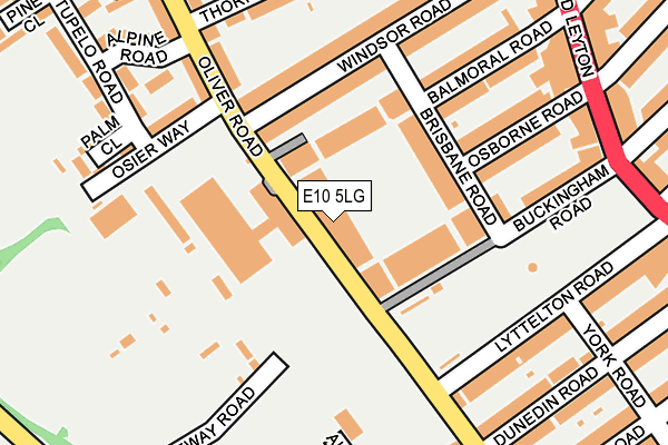
E10 5LG is located in the Leyton electoral ward, within the London borough of Waltham Forest and the English Parliamentary constituency of Leyton and Wanstead. The Sub Integrated Care Board (ICB) Location is NHS North East London ICB - A3A8R and the police force is Metropolitan Police. This postcode has been in use since February 2007.


GetTheData
Source: OS OpenMap – Local (Ordnance Survey)
Source: OS VectorMap District (Ordnance Survey)
Licence: Open Government Licence (requires attribution)
| Easting | 537815 |
| Northing | 186427 |
| Latitude | 51.559894 |
| Longitude | -0.013313 |
GetTheData
Source: Open Postcode Geo
Licence: Open Government Licence
| Country | England |
| Postcode District | E10 |
➜ See where E10 is on a map ➜ Where is Leyton? | |
GetTheData
Source: Land Registry Price Paid Data
Licence: Open Government Licence
Elevation or altitude of E10 5LG as distance above sea level:
| Metres | Feet | |
|---|---|---|
| Elevation | 10m | 33ft |
Elevation is measured from the approximate centre of the postcode, to the nearest point on an OS contour line from OS Terrain 50, which has contour spacing of ten vertical metres.
➜ How high above sea level am I? Find the elevation of your current position using your device's GPS.
GetTheData
Source: Open Postcode Elevation
Licence: Open Government Licence
| Ward | Leyton |
| Constituency | Leyton And Wanstead |
GetTheData
Source: ONS Postcode Database
Licence: Open Government Licence
| Buckingham Road (E10) (Leyton High Road) | Leyton | 253m |
| Buckingham Road (E10) (Leyton High Road) | Leyton | 262m |
| Oliver Road Ruckholt Road | Leyton | 289m |
| Grange Park Road (Leyton High Road) | Leyton | 332m |
| Oliver Road Ruckholt Road | Leyton | 337m |
| Leyton Underground Station | Leyton | 654m |
| Leytonstone Underground Station | Leytonstone | 1,761m |
| Leyton Midland Road Station | 1.2km |
| Leytonstone High Road Station | 1.6km |
| Stratford International Station | 1.7km |
GetTheData
Source: NaPTAN
Licence: Open Government Licence
GetTheData
Source: ONS Postcode Database
Licence: Open Government Licence


➜ Get more ratings from the Food Standards Agency
GetTheData
Source: Food Standards Agency
Licence: FSA terms & conditions
| Last Collection | |||
|---|---|---|---|
| Location | Mon-Fri | Sat | Distance |
| Oliver Road | 17:30 | 11:30 | 251m |
| Oliver Close | 17:30 | 11:30 | 281m |
| 354 High Road Leyton E10 | 18:30 | 12:00 | 322m |
GetTheData
Source: Dracos
Licence: Creative Commons Attribution-ShareAlike
The below table lists the International Territorial Level (ITL) codes (formerly Nomenclature of Territorial Units for Statistics (NUTS) codes) and Local Administrative Units (LAU) codes for E10 5LG:
| ITL 1 Code | Name |
|---|---|
| TLI | London |
| ITL 2 Code | Name |
| TLI5 | Outer London - East and North East |
| ITL 3 Code | Name |
| TLI53 | Redbridge and Waltham Forest |
| LAU 1 Code | Name |
| E09000031 | Waltham Forest |
GetTheData
Source: ONS Postcode Directory
Licence: Open Government Licence
The below table lists the Census Output Area (OA), Lower Layer Super Output Area (LSOA), and Middle Layer Super Output Area (MSOA) for E10 5LG:
| Code | Name | |
|---|---|---|
| OA | E00022305 | |
| LSOA | E01004429 | Waltham Forest 026C |
| MSOA | E02000920 | Waltham Forest 026 |
GetTheData
Source: ONS Postcode Directory
Licence: Open Government Licence
| E10 5LE | Oliver Road | 67m |
| E10 5LF | Oliver Road | 70m |
| E10 5GS | Buckingham Road | 82m |
| E10 5NY | Brisbane Road | 119m |
| E10 5NZ | Brisbane Road | 121m |
| E10 5NE | Brisbane Road | 146m |
| E10 5LR | Windsor Road | 160m |
| E10 5LP | Windsor Road | 169m |
| E10 5QW | Osborne Road | 171m |
| E10 5SB | Osier Way | 179m |
GetTheData
Source: Open Postcode Geo; Land Registry Price Paid Data
Licence: Open Government Licence