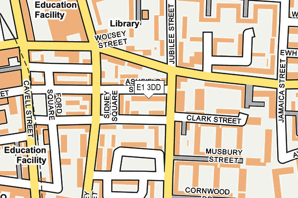
E1 3DD lies on Ashfield Street in London. E1 3DD is located in the Stepney Green electoral ward, within the London borough of Tower Hamlets and the English Parliamentary constituency of Bethnal Green and Bow. The Sub Integrated Care Board (ICB) Location is NHS North East London ICB - A3A8R and the police force is Metropolitan Police. This postcode has been in use since April 1985.


GetTheData
Source: OS OpenMap – Local (Ordnance Survey)
Source: OS VectorMap District (Ordnance Survey)
Licence: Open Government Licence (requires attribution)
| Easting | 535145 |
| Northing | 181544 |
| Latitude | 51.516660 |
| Longitude | -0.053679 |
GetTheData
Source: Open Postcode Geo
Licence: Open Government Licence
| Street | Ashfield Street |
| Town/City | London |
| Country | England |
| Postcode District | E1 |
➜ See where E1 is on a map ➜ Where is Stepney? | |
GetTheData
Source: Land Registry Price Paid Data
Licence: Open Government Licence
Elevation or altitude of E1 3DD as distance above sea level:
| Metres | Feet | |
|---|---|---|
| Elevation | 10m | 33ft |
Elevation is measured from the approximate centre of the postcode, to the nearest point on an OS contour line from OS Terrain 50, which has contour spacing of ten vertical metres.
➜ How high above sea level am I? Find the elevation of your current position using your device's GPS.
GetTheData
Source: Open Postcode Elevation
Licence: Open Government Licence
| Ward | Stepney Green |
| Constituency | Bethnal Green And Bow |
GetTheData
Source: ONS Postcode Database
Licence: Open Government Licence
| Musbury Street (Jubilee Street) | Shadwell | 97m |
| Musbury Street (Jubilee Street) | Shadwell | 229m |
| St Mary's & St Michael's Church | Shadwell | 291m |
| Watney Market | Shadwell | 294m |
| St Mary's & St Michael's Church (Commercial Road) | Shadwell | 309m |
| Whitechapel Underground Station | Whitechapel | 540m |
| Shadwell Dlr Station (Martha Street) | Shadwell | 590m |
| Stepney Green Underground Station | Stepney Green | 759m |
| Limehouse Dlr Station (Commercial Road) | Limehouse | 1,073m |
| Bethnal Green Underground Station | Bethnal Green | 1,182m |
| Whitechapel Station | 0.5km |
| Shadwell Station | 0.6km |
| Bethnal Green Station | 0.9km |
GetTheData
Source: NaPTAN
Licence: Open Government Licence
| Percentage of properties with Next Generation Access | 100.0% |
| Percentage of properties with Superfast Broadband | 100.0% |
| Percentage of properties with Ultrafast Broadband | 0.0% |
| Percentage of properties with Full Fibre Broadband | 0.0% |
Superfast Broadband is between 30Mbps and 300Mbps
Ultrafast Broadband is > 300Mbps
| Median download speed | 56.1Mbps |
| Average download speed | 48.5Mbps |
| Maximum download speed | 71.18Mbps |
| Median upload speed | 15.5Mbps |
| Average upload speed | 13.6Mbps |
| Maximum upload speed | 20.36Mbps |
| Percentage of properties unable to receive 2Mbps | 0.0% |
| Percentage of properties unable to receive 5Mbps | 0.0% |
| Percentage of properties unable to receive 10Mbps | 0.0% |
| Percentage of properties unable to receive 30Mbps | 0.0% |
GetTheData
Source: Ofcom
Licence: Ofcom Terms of Use (requires attribution)
Estimated total energy consumption in E1 3DD by fuel type, 2015.
| Consumption (kWh) | 234,924 |
|---|---|
| Meter count | 17 |
| Mean (kWh/meter) | 13,819 |
| Median (kWh/meter) | 14,006 |
| Consumption (kWh) | 56,416 |
|---|---|
| Meter count | 14 |
| Mean (kWh/meter) | 4,030 |
| Median (kWh/meter) | 3,621 |
GetTheData
Source: Postcode level gas estimates: 2015 (experimental)
Source: Postcode level electricity estimates: 2015 (experimental)
Licence: Open Government Licence
GetTheData
Source: ONS Postcode Database
Licence: Open Government Licence


➜ Get more ratings from the Food Standards Agency
GetTheData
Source: Food Standards Agency
Licence: FSA terms & conditions
| Last Collection | |||
|---|---|---|---|
| Location | Mon-Fri | Sat | Distance |
| Jubilee Street | 18:30 | 11:30 | 239m |
| Commercial Road | 18:30 | 11:30 | 251m |
| Commercial Road | 18:30 | 11:30 | 266m |
GetTheData
Source: Dracos
Licence: Creative Commons Attribution-ShareAlike
The below table lists the International Territorial Level (ITL) codes (formerly Nomenclature of Territorial Units for Statistics (NUTS) codes) and Local Administrative Units (LAU) codes for E1 3DD:
| ITL 1 Code | Name |
|---|---|
| TLI | London |
| ITL 2 Code | Name |
| TLI4 | Inner London - East |
| ITL 3 Code | Name |
| TLI42 | Tower Hamlets |
| LAU 1 Code | Name |
| E09000030 | Tower Hamlets |
GetTheData
Source: ONS Postcode Directory
Licence: Open Government Licence
The below table lists the Census Output Area (OA), Lower Layer Super Output Area (LSOA), and Middle Layer Super Output Area (MSOA) for E1 3DD:
| Code | Name | |
|---|---|---|
| OA | E00021764 | |
| LSOA | E01004323 | Tower Hamlets 017B |
| MSOA | E02000880 | Tower Hamlets 017 |
GetTheData
Source: ONS Postcode Directory
Licence: Open Government Licence
| E1 3EU | Clark Street | 28m |
| E1 3EX | Ashfield Street | 40m |
| E1 3DU | Magri Walk | 48m |
| E1 2EY | Sidney Square | 58m |
| E1 3ET | Clark Street | 62m |
| E1 3HS | Clark Street | 62m |
| E1 3DY | Ashfield Yard | 63m |
| E1 3ER | Jubilee Street | 79m |
| E1 3EG | Jubilee Street | 88m |
| E1 3BQ | Stepney Way | 93m |
GetTheData
Source: Open Postcode Geo; Land Registry Price Paid Data
Licence: Open Government Licence