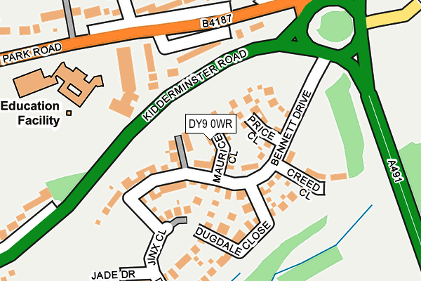
DY9 0WR is located in the Hagley East electoral ward, within the local authority district of Bromsgrove and the English Parliamentary constituency of Bromsgrove. The Sub Integrated Care Board (ICB) Location is NHS Herefordshire and Worcestershire ICB - 18C and the police force is West Mercia. This postcode has been in use since March 2017.


GetTheData
Source: OS OpenMap – Local (Ordnance Survey)
Source: OS VectorMap District (Ordnance Survey)
Licence: Open Government Licence (requires attribution)
| Easting | 390946 |
| Northing | 280365 |
| Latitude | 52.421213 |
| Longitude | -2.134556 |
GetTheData
Source: Open Postcode Geo
Licence: Open Government Licence
| Country | England |
| Postcode District | DY9 |
➜ See where DY9 is on a map ➜ Where is Hagley? | |
GetTheData
Source: Land Registry Price Paid Data
Licence: Open Government Licence
| Ward | Hagley East |
| Constituency | Bromsgrove |
GetTheData
Source: ONS Postcode Database
Licence: Open Government Licence
| Hagley Primary School (Park Road) | Hagley | 228m |
| War Memorial (Park Road) | Hagley | 241m |
| Hagley Primary School (Park Road) | Hagley | 260m |
| Lyttleton Place (Park Road) | Hagley | 400m |
| Station Road (Park Road) | Hagley | 510m |
| Hagley Station | 0.8km |
| Stourbridge Junction Station | 2.9km |
| Blakedown Station | 3.3km |
GetTheData
Source: NaPTAN
Licence: Open Government Licence
| Percentage of properties with Next Generation Access | 0.0% |
| Percentage of properties with Superfast Broadband | 0.0% |
| Percentage of properties with Ultrafast Broadband | 0.0% |
| Percentage of properties with Full Fibre Broadband | 0.0% |
Superfast Broadband is between 30Mbps and 300Mbps
Ultrafast Broadband is > 300Mbps
| Median download speed | 16.4Mbps |
| Average download speed | 15.4Mbps |
| Maximum download speed | 20.92Mbps |
| Median upload speed | 1.1Mbps |
| Average upload speed | 1.0Mbps |
| Maximum upload speed | 1.28Mbps |
| Percentage of properties unable to receive 2Mbps | 0.0% |
| Percentage of properties unable to receive 5Mbps | 0.0% |
| Percentage of properties unable to receive 10Mbps | 0.0% |
| Percentage of properties unable to receive 30Mbps | 100.0% |
GetTheData
Source: Ofcom
Licence: Ofcom Terms of Use (requires attribution)
GetTheData
Source: ONS Postcode Database
Licence: Open Government Licence


➜ Get more ratings from the Food Standards Agency
GetTheData
Source: Food Standards Agency
Licence: FSA terms & conditions
| Last Collection | |||
|---|---|---|---|
| Location | Mon-Fri | Sat | Distance |
| Hall Lane | 17:15 | 10:30 | 817m |
| Pinewoods Avenue | 17:30 | 10:45 | 1,625m |
| Broome | 16:00 | 10:00 | 2,029m |
GetTheData
Source: Dracos
Licence: Creative Commons Attribution-ShareAlike
The below table lists the International Territorial Level (ITL) codes (formerly Nomenclature of Territorial Units for Statistics (NUTS) codes) and Local Administrative Units (LAU) codes for DY9 0WR:
| ITL 1 Code | Name |
|---|---|
| TLG | West Midlands (England) |
| ITL 2 Code | Name |
| TLG1 | Herefordshire, Worcestershire and Warwickshire |
| ITL 3 Code | Name |
| TLG12 | Worcestershire CC |
| LAU 1 Code | Name |
| E07000234 | Bromsgrove |
GetTheData
Source: ONS Postcode Directory
Licence: Open Government Licence
The below table lists the Census Output Area (OA), Lower Layer Super Output Area (LSOA), and Middle Layer Super Output Area (MSOA) for DY9 0WR:
| Code | Name | |
|---|---|---|
| OA | E00163936 | |
| LSOA | E01032139 | Bromsgrove 001B |
| MSOA | E02006696 | Bromsgrove 001 |
GetTheData
Source: ONS Postcode Directory
Licence: Open Government Licence
| DY9 0WQ | Luckett Close | 44m |
| DY9 0WS | Price Close | 57m |
| DY9 0WA | Bennett Drive | 68m |
| DY9 0WD | Dugdale Close | 125m |
| DY9 0QF | Park Road | 138m |
| DY9 0AP | Park Road | 166m |
| DY9 0QQ | Park Road | 235m |
| DY9 0QG | Oldfields | 297m |
| DY9 0PX | Middlefield Lane | 310m |
| DY9 0NS | Park Road | 359m |
GetTheData
Source: Open Postcode Geo; Land Registry Price Paid Data
Licence: Open Government Licence