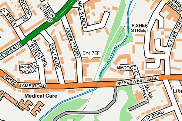
DY4 7EF is located in the Great Bridge electoral ward, within the metropolitan district of Sandwell and the English Parliamentary constituency of West Bromwich West. The Sub Integrated Care Board (ICB) Location is NHS Black Country ICB - D2P2L and the police force is West Midlands. This postcode has been in use since January 1980.


GetTheData
Source: OS OpenMap – Local (Ordnance Survey)
Source: OS VectorMap District (Ordnance Survey)
Licence: Open Government Licence (requires attribution)
| Easting | 397636 |
| Northing | 292257 |
| Latitude | 52.528179 |
| Longitude | -2.036276 |
GetTheData
Source: Open Postcode Geo
Licence: Open Government Licence
| Country | England |
| Postcode District | DY4 |
➜ See where DY4 is on a map ➜ Where is Tipton? | |
GetTheData
Source: Land Registry Price Paid Data
Licence: Open Government Licence
Elevation or altitude of DY4 7EF as distance above sea level:
| Metres | Feet | |
|---|---|---|
| Elevation | 130m | 427ft |
Elevation is measured from the approximate centre of the postcode, to the nearest point on an OS contour line from OS Terrain 50, which has contour spacing of ten vertical metres.
➜ How high above sea level am I? Find the elevation of your current position using your device's GPS.
GetTheData
Source: Open Postcode Elevation
Licence: Open Government Licence
| Ward | Great Bridge |
| Constituency | West Bromwich West |
GetTheData
Source: ONS Postcode Database
Licence: Open Government Licence
| Great Bridge Interchange (Great Bridge Bus Station) | Great Bridge | 220m |
| Providence St (Horseley Heath) | Great Bridge | 228m |
| Great Bridge Interchange (Great Bridge Bus Station) | Great Bridge | 230m |
| Great Bridge Interchange (Great Bridge Bus Station) | Great Bridge | 239m |
| Providence St (Horseley Heath) | Great Bridge | 252m |
| Dudley Port Station | 1km |
| Tipton Station | 2km |
| Sandwell & Dudley Station | 2.7km |
GetTheData
Source: NaPTAN
Licence: Open Government Licence
GetTheData
Source: ONS Postcode Database
Licence: Open Government Licence


➜ Get more ratings from the Food Standards Agency
GetTheData
Source: Food Standards Agency
Licence: FSA terms & conditions
| Last Collection | |||
|---|---|---|---|
| Location | Mon-Fri | Sat | Distance |
| Great Bridge Post Office | 18:30 | 12:00 | 321m |
| Sheepwash Lane | 18:30 | 11:30 | 326m |
| Great Bridge St Opposite Charl | 17:30 | 12:00 | 636m |
GetTheData
Source: Dracos
Licence: Creative Commons Attribution-ShareAlike
The below table lists the International Territorial Level (ITL) codes (formerly Nomenclature of Territorial Units for Statistics (NUTS) codes) and Local Administrative Units (LAU) codes for DY4 7EF:
| ITL 1 Code | Name |
|---|---|
| TLG | West Midlands (England) |
| ITL 2 Code | Name |
| TLG3 | West Midlands |
| ITL 3 Code | Name |
| TLG37 | Sandwell |
| LAU 1 Code | Name |
| E08000028 | Sandwell |
GetTheData
Source: ONS Postcode Directory
Licence: Open Government Licence
The below table lists the Census Output Area (OA), Lower Layer Super Output Area (LSOA), and Middle Layer Super Output Area (MSOA) for DY4 7EF:
| Code | Name | |
|---|---|---|
| OA | E00050503 | |
| LSOA | E01009979 | Sandwell 016C |
| MSOA | E02002058 | Sandwell 016 |
GetTheData
Source: ONS Postcode Directory
Licence: Open Government Licence
| DY4 7ED | Lewis Street | 56m |
| DY4 7JB | Sheepwash Lane | 93m |
| DY4 7DZ | Ballfields | 97m |
| DY4 7EB | Lewis Street | 117m |
| DY4 7DY | Ballfields | 120m |
| DY4 7EG | Mill Street | 123m |
| DY4 7HZ | Beddoe Close | 127m |
| DY4 7DX | Providence Street | 152m |
| DY4 7JA | Tame Road | 155m |
| DY4 7DT | Providence Street | 174m |
GetTheData
Source: Open Postcode Geo; Land Registry Price Paid Data
Licence: Open Government Licence