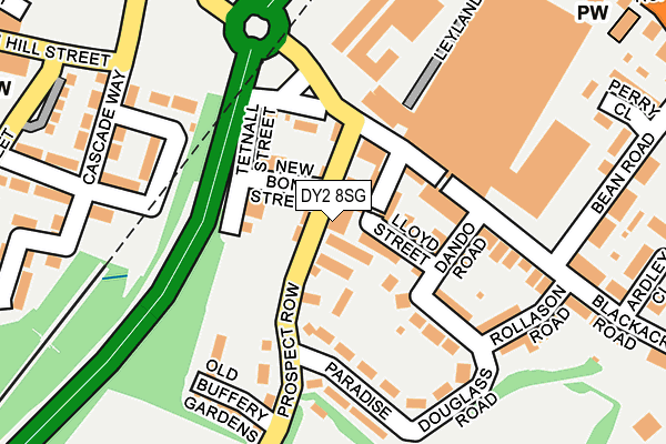
DY2 8SG lies on Prospect Row in Dudley. DY2 8SG is located in the St Thomas's electoral ward, within the metropolitan district of Dudley and the English Parliamentary constituency of Dudley North. The Sub Integrated Care Board (ICB) Location is NHS Black Country ICB - D2P2L and the police force is West Midlands. This postcode has been in use since January 1980.


GetTheData
Source: OS OpenMap – Local (Ordnance Survey)
Source: OS VectorMap District (Ordnance Survey)
Licence: Open Government Licence (requires attribution)
| Easting | 394682 |
| Northing | 289749 |
| Latitude | 52.505626 |
| Longitude | -2.079772 |
GetTheData
Source: Open Postcode Geo
Licence: Open Government Licence
| Street | Prospect Row |
| Town/City | Dudley |
| Country | England |
| Postcode District | DY2 |
➜ See where DY2 is on a map ➜ Where is Dudley? | |
GetTheData
Source: Land Registry Price Paid Data
Licence: Open Government Licence
Elevation or altitude of DY2 8SG as distance above sea level:
| Metres | Feet | |
|---|---|---|
| Elevation | 200m | 656ft |
Elevation is measured from the approximate centre of the postcode, to the nearest point on an OS contour line from OS Terrain 50, which has contour spacing of ten vertical metres.
➜ How high above sea level am I? Find the elevation of your current position using your device's GPS.
GetTheData
Source: Open Postcode Elevation
Licence: Open Government Licence
| Ward | St Thomas's |
| Constituency | Dudley North |
GetTheData
Source: ONS Postcode Database
Licence: Open Government Licence
| The Barley Mow (Prospect Row) | Kates Hill | 24m |
| The Barley Mow (Prospect Row) | Kates Hill | 64m |
| The Struggling Man (Prospect Row) | Dixons Green | 197m |
| The Struggling Man (Prospect Row) | Dixons Green | 236m |
| St John's Rd (Dixons Green Rd) | Kates Hill | 337m |
| Tipton Station | 2.9km |
| Dudley Port Station | 3km |
| Cradley Heath Station | 4.1km |
GetTheData
Source: NaPTAN
Licence: Open Government Licence
Estimated total energy consumption in DY2 8SG by fuel type, 2015.
| Consumption (kWh) | 27,878 |
|---|---|
| Meter count | 8 |
| Mean (kWh/meter) | 3,485 |
| Median (kWh/meter) | 2,109 |
GetTheData
Source: Postcode level gas estimates: 2015 (experimental)
Source: Postcode level electricity estimates: 2015 (experimental)
Licence: Open Government Licence
GetTheData
Source: ONS Postcode Database
Licence: Open Government Licence


➜ Get more ratings from the Food Standards Agency
GetTheData
Source: Food Standards Agency
Licence: FSA terms & conditions
| Last Collection | |||
|---|---|---|---|
| Location | Mon-Fri | Sat | Distance |
| Hall Street | 17:30 | 11:00 | 341m |
| Dixons Green Post Office | 17:30 | 12:00 | 508m |
| Lister Road | 17:30 | 11:00 | 591m |
GetTheData
Source: Dracos
Licence: Creative Commons Attribution-ShareAlike
The below table lists the International Territorial Level (ITL) codes (formerly Nomenclature of Territorial Units for Statistics (NUTS) codes) and Local Administrative Units (LAU) codes for DY2 8SG:
| ITL 1 Code | Name |
|---|---|
| TLG | West Midlands (England) |
| ITL 2 Code | Name |
| TLG3 | West Midlands |
| ITL 3 Code | Name |
| TLG36 | Dudley |
| LAU 1 Code | Name |
| E08000027 | Dudley |
GetTheData
Source: ONS Postcode Directory
Licence: Open Government Licence
The below table lists the Census Output Area (OA), Lower Layer Super Output Area (LSOA), and Middle Layer Super Output Area (MSOA) for DY2 8SG:
| Code | Name | |
|---|---|---|
| OA | E00050028 | |
| LSOA | E01009889 | Dudley 015C |
| MSOA | E02002014 | Dudley 015 |
GetTheData
Source: ONS Postcode Directory
Licence: Open Government Licence
| DY2 8NG | Lloyd Street | 48m |
| DY2 8NJ | Shedden Street | 50m |
| DY2 8NQ | Lloyd Street | 66m |
| DY2 8SL | Spring Gardens | 74m |
| DY2 8NH | Dando Road | 92m |
| DY2 8NB | Blackacre Road | 130m |
| DY2 8SH | Paradise | 139m |
| DY2 8NF | Douglas Road | 140m |
| DY2 8NE | Douglas Road | 149m |
| DY2 8SQ | Prospect Row | 155m |
GetTheData
Source: Open Postcode Geo; Land Registry Price Paid Data
Licence: Open Government Licence