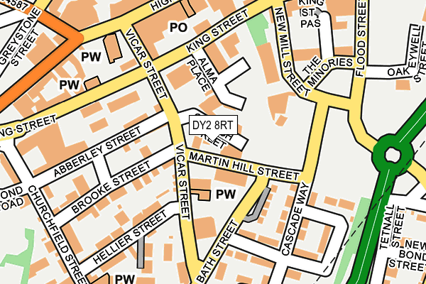
DY2 8RT is located in the St Thomas's electoral ward, within the metropolitan district of Dudley and the English Parliamentary constituency of Dudley North. The Sub Integrated Care Board (ICB) Location is NHS Black Country ICB - D2P2L and the police force is West Midlands. This postcode has been in use since October 1985.


GetTheData
Source: OS OpenMap – Local (Ordnance Survey)
Source: OS VectorMap District (Ordnance Survey)
Licence: Open Government Licence (requires attribution)
| Easting | 394386 |
| Northing | 289930 |
| Latitude | 52.507250 |
| Longitude | -2.084136 |
GetTheData
Source: Open Postcode Geo
Licence: Open Government Licence
| Country | England |
| Postcode District | DY2 |
➜ See where DY2 is on a map ➜ Where is Dudley? | |
GetTheData
Source: Land Registry Price Paid Data
Licence: Open Government Licence
Elevation or altitude of DY2 8RT as distance above sea level:
| Metres | Feet | |
|---|---|---|
| Elevation | 200m | 656ft |
Elevation is measured from the approximate centre of the postcode, to the nearest point on an OS contour line from OS Terrain 50, which has contour spacing of ten vertical metres.
➜ How high above sea level am I? Find the elevation of your current position using your device's GPS.
GetTheData
Source: Open Postcode Elevation
Licence: Open Government Licence
| Ward | St Thomas's |
| Constituency | Dudley North |
GetTheData
Source: ONS Postcode Database
Licence: Open Government Licence
| Vicar St (King St) | Dudley | 184m |
| Vicar St (King St) | Dudley | 195m |
| King St (Flood St) | Dudley | 262m |
| Vicar Street (High St) | Dudley | 264m |
| Flood St (King St) | Dudley | 276m |
| Tipton Station | 2.9km |
| Dudley Port Station | 3km |
| Cradley Heath Station | 4.2km |
GetTheData
Source: NaPTAN
Licence: Open Government Licence
GetTheData
Source: ONS Postcode Database
Licence: Open Government Licence


➜ Get more ratings from the Food Standards Agency
GetTheData
Source: Food Standards Agency
Licence: FSA terms & conditions
| Last Collection | |||
|---|---|---|---|
| Location | Mon-Fri | Sat | Distance |
| Hall Street | 17:30 | 11:00 | 538m |
| Dudley Post Office | 19:00 | 12:00 | 546m |
| Lister Road | 17:30 | 11:00 | 663m |
GetTheData
Source: Dracos
Licence: Creative Commons Attribution-ShareAlike
The below table lists the International Territorial Level (ITL) codes (formerly Nomenclature of Territorial Units for Statistics (NUTS) codes) and Local Administrative Units (LAU) codes for DY2 8RT:
| ITL 1 Code | Name |
|---|---|
| TLG | West Midlands (England) |
| ITL 2 Code | Name |
| TLG3 | West Midlands |
| ITL 3 Code | Name |
| TLG36 | Dudley |
| LAU 1 Code | Name |
| E08000027 | Dudley |
GetTheData
Source: ONS Postcode Directory
Licence: Open Government Licence
The below table lists the Census Output Area (OA), Lower Layer Super Output Area (LSOA), and Middle Layer Super Output Area (MSOA) for DY2 8RT:
| Code | Name | |
|---|---|---|
| OA | E00050050 | |
| LSOA | E01009889 | Dudley 015C |
| MSOA | E02002014 | Dudley 015 |
GetTheData
Source: ONS Postcode Directory
Licence: Open Government Licence
| DY2 8RN | Bath Street | 89m |
| DY2 8RB | Brooke Street | 131m |
| DY2 8QY | Abberley Street | 146m |
| DY2 8RF | Hellier Street | 159m |
| DY2 8RL | Wellspring Gardens | 162m |
| DY2 8RG | Vicar Street | 163m |
| DY2 8RJ | Cascade Way | 183m |
| DY1 1PY | High Street | 212m |
| DY2 8RE | Hellier Street | 219m |
| DY2 8RA | Brooke Street | 225m |
GetTheData
Source: Open Postcode Geo; Land Registry Price Paid Data
Licence: Open Government Licence