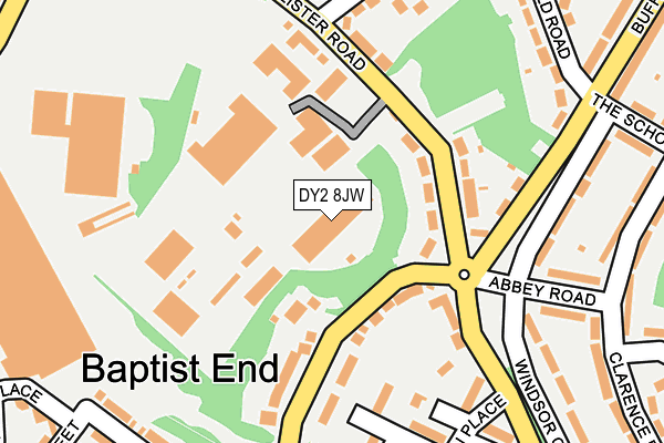
DY2 8JW is located in the St Thomas's electoral ward, within the metropolitan district of Dudley and the English Parliamentary constituency of Dudley North. The Sub Integrated Care Board (ICB) Location is NHS Black Country ICB - D2P2L and the police force is West Midlands. This postcode has been in use since August 2007.


GetTheData
Source: OS OpenMap – Local (Ordnance Survey)
Source: OS VectorMap District (Ordnance Survey)
Licence: Open Government Licence (requires attribution)
| Easting | 394564 |
| Northing | 288976 |
| Latitude | 52.498675 |
| Longitude | -2.081498 |
GetTheData
Source: Open Postcode Geo
Licence: Open Government Licence
| Country | England |
| Postcode District | DY2 |
➜ See where DY2 is on a map ➜ Where is Dudley? | |
GetTheData
Source: Land Registry Price Paid Data
Licence: Open Government Licence
Elevation or altitude of DY2 8JW as distance above sea level:
| Metres | Feet | |
|---|---|---|
| Elevation | 150m | 492ft |
Elevation is measured from the approximate centre of the postcode, to the nearest point on an OS contour line from OS Terrain 50, which has contour spacing of ten vertical metres.
➜ How high above sea level am I? Find the elevation of your current position using your device's GPS.
GetTheData
Source: Open Postcode Elevation
Licence: Open Government Licence
| Ward | St Thomas's |
| Constituency | Dudley North |
GetTheData
Source: ONS Postcode Database
Licence: Open Government Licence
| Baptist End Rd (Lister Rd) | Baptist End | 105m |
| Baptist End Rd (Lister Rd) | Baptist End | 112m |
| Lister Rd (Buffery Rd) | Baptist End | 150m |
| Lister Rd (Buffery Rd) | Baptist End | 159m |
| Summerfield Rd (Buffery Rd) | Baptist End | 276m |
| Cradley Heath Station | 3.3km |
| Old Hill Station | 3.5km |
| Dudley Port Station | 3.6km |
GetTheData
Source: NaPTAN
Licence: Open Government Licence
GetTheData
Source: ONS Postcode Database
Licence: Open Government Licence


➜ Get more ratings from the Food Standards Agency
GetTheData
Source: Food Standards Agency
Licence: FSA terms & conditions
| Last Collection | |||
|---|---|---|---|
| Location | Mon-Fri | Sat | Distance |
| Lister Road | 17:30 | 11:00 | 370m |
| Cinder Bank | 17:30 | 11:00 | 452m |
| Dixons Green Post Office | 17:30 | 12:00 | 476m |
GetTheData
Source: Dracos
Licence: Creative Commons Attribution-ShareAlike
The below table lists the International Territorial Level (ITL) codes (formerly Nomenclature of Territorial Units for Statistics (NUTS) codes) and Local Administrative Units (LAU) codes for DY2 8JW:
| ITL 1 Code | Name |
|---|---|
| TLG | West Midlands (England) |
| ITL 2 Code | Name |
| TLG3 | West Midlands |
| ITL 3 Code | Name |
| TLG36 | Dudley |
| LAU 1 Code | Name |
| E08000027 | Dudley |
GetTheData
Source: ONS Postcode Directory
Licence: Open Government Licence
The below table lists the Census Output Area (OA), Lower Layer Super Output Area (LSOA), and Middle Layer Super Output Area (MSOA) for DY2 8JW:
| Code | Name | |
|---|---|---|
| OA | E00050021 | |
| LSOA | E01009887 | Dudley 015A |
| MSOA | E02002014 | Dudley 015 |
GetTheData
Source: ONS Postcode Directory
Licence: Open Government Licence
| DY2 8JT | Lister Road | 90m |
| DY2 8HY | Baptist End Road | 107m |
| DY2 8HZ | Baptist End Road | 128m |
| DY2 8JS | Lister Road | 129m |
| DY2 8JU | Buffery Road | 172m |
| DY2 8HF | Windsor Crescent | 216m |
| DY2 8HP | Kilburn Place | 222m |
| DY2 8HS | St Peters Road | 234m |
| DY2 8JX | Fairfield Road | 242m |
| DY2 9EB | Round Street | 254m |
GetTheData
Source: Open Postcode Geo; Land Registry Price Paid Data
Licence: Open Government Licence