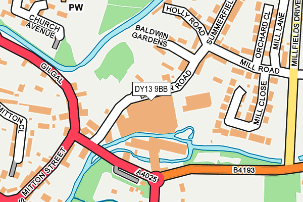
DY13 9BB is located in the Mitton electoral ward, within the local authority district of Wyre Forest and the English Parliamentary constituency of Wyre Forest. The Sub Integrated Care Board (ICB) Location is NHS Herefordshire and Worcestershire ICB - 18C and the police force is West Mercia. This postcode has been in use since June 1981.


GetTheData
Source: OS OpenMap – Local (Ordnance Survey)
Source: OS VectorMap District (Ordnance Survey)
Licence: Open Government Licence (requires attribution)
| Easting | 381635 |
| Northing | 271540 |
| Latitude | 52.341626 |
| Longitude | -2.270987 |
GetTheData
Source: Open Postcode Geo
Licence: Open Government Licence
| Country | England |
| Postcode District | DY13 |
➜ See where DY13 is on a map ➜ Where is Stourport-on-Severn? | |
GetTheData
Source: Land Registry Price Paid Data
Licence: Open Government Licence
Elevation or altitude of DY13 9BB as distance above sea level:
| Metres | Feet | |
|---|---|---|
| Elevation | 20m | 66ft |
Elevation is measured from the approximate centre of the postcode, to the nearest point on an OS contour line from OS Terrain 50, which has contour spacing of ten vertical metres.
➜ How high above sea level am I? Find the elevation of your current position using your device's GPS.
GetTheData
Source: Open Postcode Elevation
Licence: Open Government Licence
| Ward | Mitton |
| Constituency | Wyre Forest |
GetTheData
Source: ONS Postcode Database
Licence: Open Government Licence
| Worcester Road Island (Parsons Chain Works) | Stourport-on-severn | 193m |
| Hartlebury Road (Parsons Chain Works) | Stourport-on-severn | 193m |
| Mitton Street | Stourport-on-severn | 215m |
| Mill Road | Stourport-on-severn | 290m |
| Vale Road | Stourport-on-severn | 373m |
| Hartlebury Station | 3.5km |
| Kidderminster Station | 5.3km |
GetTheData
Source: NaPTAN
Licence: Open Government Licence
GetTheData
Source: ONS Postcode Database
Licence: Open Government Licence


➜ Get more ratings from the Food Standards Agency
GetTheData
Source: Food Standards Agency
Licence: FSA terms & conditions
| Last Collection | |||
|---|---|---|---|
| Location | Mon-Fri | Sat | Distance |
| Mitton Park | 16:45 | 09:00 | 268m |
| Mart Lane | 17:00 | 08:00 | 611m |
| Hartlebury Post Office | 18:30 | 09:00 | 3,060m |
GetTheData
Source: Dracos
Licence: Creative Commons Attribution-ShareAlike
| Risk of DY13 9BB flooding from rivers and sea | Medium |
| ➜ DY13 9BB flood map | |
GetTheData
Source: Open Flood Risk by Postcode
Licence: Open Government Licence
The below table lists the International Territorial Level (ITL) codes (formerly Nomenclature of Territorial Units for Statistics (NUTS) codes) and Local Administrative Units (LAU) codes for DY13 9BB:
| ITL 1 Code | Name |
|---|---|
| TLG | West Midlands (England) |
| ITL 2 Code | Name |
| TLG1 | Herefordshire, Worcestershire and Warwickshire |
| ITL 3 Code | Name |
| TLG12 | Worcestershire CC |
| LAU 1 Code | Name |
| E07000239 | Wyre Forest |
GetTheData
Source: ONS Postcode Directory
Licence: Open Government Licence
The below table lists the Census Output Area (OA), Lower Layer Super Output Area (LSOA), and Middle Layer Super Output Area (MSOA) for DY13 9BB:
| Code | Name | |
|---|---|---|
| OA | E00165569 | |
| LSOA | E01032460 | Wyre Forest 013A |
| MSOA | E02006779 | Wyre Forest 013 |
GetTheData
Source: ONS Postcode Directory
Licence: Open Government Licence
| DY13 9AU | Baldwin Road | 30m |
| DY13 9AZ | Baldwin Road | 104m |
| DY13 9GX | Baldwin Gardens | 130m |
| DY13 9AL | Gilgal | 149m |
| DY13 9BG | Mill Road | 164m |
| DY13 9BD | Canalside | 188m |
| DY13 9BU | Mill Close | 192m |
| DY13 9BA | Holly Road | 194m |
| DY13 9AJ | Gilgal | 220m |
| DY13 9AB | Mitton Gardens | 240m |
GetTheData
Source: Open Postcode Geo; Land Registry Price Paid Data
Licence: Open Government Licence