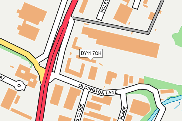
DY11 7QH is located in the Foley Park & Hoobrook electoral ward, within the local authority district of Wyre Forest and the English Parliamentary constituency of Wyre Forest. The Sub Integrated Care Board (ICB) Location is NHS Herefordshire and Worcestershire ICB - 18C and the police force is West Mercia. This postcode has been in use since June 2000.


GetTheData
Source: OS OpenMap – Local (Ordnance Survey)
Source: OS VectorMap District (Ordnance Survey)
Licence: Open Government Licence (requires attribution)
| Easting | 381948 |
| Northing | 273637 |
| Latitude | 52.360489 |
| Longitude | -2.266506 |
GetTheData
Source: Open Postcode Geo
Licence: Open Government Licence
| Country | England |
| Postcode District | DY11 |
➜ See where DY11 is on a map ➜ Where is Kidderminster? | |
GetTheData
Source: Land Registry Price Paid Data
Licence: Open Government Licence
Elevation or altitude of DY11 7QH as distance above sea level:
| Metres | Feet | |
|---|---|---|
| Elevation | 40m | 131ft |
Elevation is measured from the approximate centre of the postcode, to the nearest point on an OS contour line from OS Terrain 50, which has contour spacing of ten vertical metres.
➜ How high above sea level am I? Find the elevation of your current position using your device's GPS.
GetTheData
Source: Open Postcode Elevation
Licence: Open Government Licence
| Ward | Foley Park & Hoobrook |
| Constituency | Wyre Forest |
GetTheData
Source: ONS Postcode Database
Licence: Open Government Licence
| Walter Nash Road West (Minster Road) | Birchen Coppice | 115m |
| Walter Nash Road West (Minster Road) | Birchen Coppice | 147m |
| Walter Nash Road West | Birchen Coppice | 320m |
| Crematorium (Minster Road) | Birchen Coppice | 333m |
| Walter Nash Road West | Birchen Coppice | 385m |
| Kidderminster Station | 3.3km |
| Hartlebury Station | 4.2km |
GetTheData
Source: NaPTAN
Licence: Open Government Licence
GetTheData
Source: ONS Postcode Database
Licence: Open Government Licence


➜ Get more ratings from the Food Standards Agency
GetTheData
Source: Food Standards Agency
Licence: FSA terms & conditions
| Last Collection | |||
|---|---|---|---|
| Location | Mon-Fri | Sat | Distance |
| White Heart | 18:00 | 08:45 | 1,349m |
| Jubilee Drive | 17:15 | 11:30 | 1,448m |
| Shrawley Avenue | 17:15 | 11:30 | 1,510m |
GetTheData
Source: Dracos
Licence: Creative Commons Attribution-ShareAlike
The below table lists the International Territorial Level (ITL) codes (formerly Nomenclature of Territorial Units for Statistics (NUTS) codes) and Local Administrative Units (LAU) codes for DY11 7QH:
| ITL 1 Code | Name |
|---|---|
| TLG | West Midlands (England) |
| ITL 2 Code | Name |
| TLG1 | Herefordshire, Worcestershire and Warwickshire |
| ITL 3 Code | Name |
| TLG12 | Worcestershire CC |
| LAU 1 Code | Name |
| E07000239 | Wyre Forest |
GetTheData
Source: ONS Postcode Directory
Licence: Open Government Licence
The below table lists the Census Output Area (OA), Lower Layer Super Output Area (LSOA), and Middle Layer Super Output Area (MSOA) for DY11 7QH:
| Code | Name | |
|---|---|---|
| OA | E00165609 | |
| LSOA | E01032469 | Wyre Forest 009A |
| MSOA | E02006775 | Wyre Forest 009 |
GetTheData
Source: ONS Postcode Directory
Licence: Open Government Licence
| DY11 7QN | Firs Industrial Estate | 178m |
| DY11 7FB | Finepoint Way | 337m |
| DY11 7QY | Coppice Trading Estate | 436m |
| DY11 7QP | Oldington Trading Estate | 558m |
| DY11 7EN | Whittall Drive West | 683m |
| DY11 7ET | Whittall Drive West | 693m |
| DY11 7EU | Walter Nash Road West | 697m |
| DY11 7EP | Bredon Avenue | 734m |
| DY11 7EW | Tolley Road | 754m |
| DY11 7HA | Kinver Avenue | 791m |
GetTheData
Source: Open Postcode Geo; Land Registry Price Paid Data
Licence: Open Government Licence