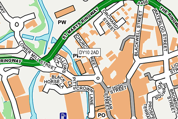
DY10 2AD lies on Church Street in Kidderminster. DY10 2AD is located in the Blakebrook & Habberley South electoral ward, within the local authority district of Wyre Forest and the English Parliamentary constituency of Wyre Forest. The Sub Integrated Care Board (ICB) Location is NHS Herefordshire and Worcestershire ICB - 18C and the police force is West Mercia. This postcode has been in use since January 1980.


GetTheData
Source: OS OpenMap – Local (Ordnance Survey)
Source: OS VectorMap District (Ordnance Survey)
Licence: Open Government Licence (requires attribution)
| Easting | 383102 |
| Northing | 276779 |
| Latitude | 52.388787 |
| Longitude | -2.249716 |
GetTheData
Source: Open Postcode Geo
Licence: Open Government Licence
| Street | Church Street |
| Town/City | Kidderminster |
| Country | England |
| Postcode District | DY10 |
➜ See where DY10 is on a map ➜ Where is Kidderminster? | |
GetTheData
Source: Land Registry Price Paid Data
Licence: Open Government Licence
Elevation or altitude of DY10 2AD as distance above sea level:
| Metres | Feet | |
|---|---|---|
| Elevation | 40m | 131ft |
Elevation is measured from the approximate centre of the postcode, to the nearest point on an OS contour line from OS Terrain 50, which has contour spacing of ten vertical metres.
➜ How high above sea level am I? Find the elevation of your current position using your device's GPS.
GetTheData
Source: Open Postcode Elevation
Licence: Open Government Licence
| Ward | Blakebrook & Habberley South |
| Constituency | Wyre Forest |
GetTheData
Source: ONS Postcode Database
Licence: Open Government Licence
| Swan Centre (Blackwell Street) | Kidderminster | 145m |
| Swan Centre (Coventry Street) | Kidderminster | 170m |
| Swan Centre (Blackwell Street) | Kidderminster | 181m |
| Town Hall (Exchange Street) | Kidderminster | 242m |
| Town Hall (Oxford Street) | Kidderminster | 246m |
| Kidderminster Station | 0.9km |
| Blakedown Station | 5.3km |
GetTheData
Source: NaPTAN
Licence: Open Government Licence
| Median download speed | 79.6Mbps |
| Average download speed | 68.0Mbps |
| Maximum download speed | 80.00Mbps |
| Median upload speed | 20.0Mbps |
| Average upload speed | 16.6Mbps |
| Maximum upload speed | 20.00Mbps |
GetTheData
Source: Ofcom
Licence: Ofcom Terms of Use (requires attribution)
Estimated total energy consumption in DY10 2AD by fuel type, 2015.
| Consumption (kWh) | 228,094 |
|---|---|
| Meter count | 10 |
| Mean (kWh/meter) | 22,809 |
| Median (kWh/meter) | 24,474 |
GetTheData
Source: Postcode level gas estimates: 2015 (experimental)
Source: Postcode level electricity estimates: 2015 (experimental)
Licence: Open Government Licence
GetTheData
Source: ONS Postcode Database
Licence: Open Government Licence


➜ Get more ratings from the Food Standards Agency
GetTheData
Source: Food Standards Agency
Licence: FSA terms & conditions
| Last Collection | |||
|---|---|---|---|
| Location | Mon-Fri | Sat | Distance |
| Kidderminster Post Office | 19:00 | 12:30 | 67m |
| Oxford Road | 18:30 | 11:45 | 229m |
| Mill Street | 17:15 | 11:45 | 417m |
GetTheData
Source: Dracos
Licence: Creative Commons Attribution-ShareAlike
The below table lists the International Territorial Level (ITL) codes (formerly Nomenclature of Territorial Units for Statistics (NUTS) codes) and Local Administrative Units (LAU) codes for DY10 2AD:
| ITL 1 Code | Name |
|---|---|
| TLG | West Midlands (England) |
| ITL 2 Code | Name |
| TLG1 | Herefordshire, Worcestershire and Warwickshire |
| ITL 3 Code | Name |
| TLG12 | Worcestershire CC |
| LAU 1 Code | Name |
| E07000239 | Wyre Forest |
GetTheData
Source: ONS Postcode Directory
Licence: Open Government Licence
The below table lists the Census Output Area (OA), Lower Layer Super Output Area (LSOA), and Middle Layer Super Output Area (MSOA) for DY10 2AD:
| Code | Name | |
|---|---|---|
| OA | E00165485 | |
| LSOA | E01032450 | Wyre Forest 004D |
| MSOA | E02006770 | Wyre Forest 004 |
GetTheData
Source: ONS Postcode Directory
Licence: Open Government Licence
| DY10 2AH | Church Street | 51m |
| DY10 2AW | Church Street | 86m |
| DY11 6UU | Lower Mill Street | 104m |
| DY10 2DJ | High Street | 131m |
| DY10 1DA | Vicar Street | 149m |
| DY10 2BH | Coventry Street | 213m |
| DY10 1EA | Worcester Street | 236m |
| DY10 1EL | Worcester Street | 293m |
| DY10 1ED | Worcester Street | 293m |
| DY10 1ER | Worcester Street | 308m |
GetTheData
Source: Open Postcode Geo; Land Registry Price Paid Data
Licence: Open Government Licence