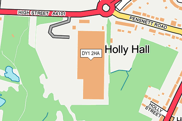
DY1 2HA is located in the Brockmoor and Pensnett electoral ward, within the metropolitan district of Dudley and the English Parliamentary constituency of Dudley South. The Sub Integrated Care Board (ICB) Location is NHS Black Country ICB - D2P2L and the police force is West Midlands. This postcode has been in use since December 1998.


GetTheData
Source: OS OpenMap – Local (Ordnance Survey)
Source: OS VectorMap District (Ordnance Survey)
Licence: Open Government Licence (requires attribution)
| Easting | 392274 |
| Northing | 289080 |
| Latitude | 52.499567 |
| Longitude | -2.115238 |
GetTheData
Source: Open Postcode Geo
Licence: Open Government Licence
| Country | England |
| Postcode District | DY1 |
➜ See where DY1 is on a map ➜ Where is Dudley? | |
GetTheData
Source: Land Registry Price Paid Data
Licence: Open Government Licence
Elevation or altitude of DY1 2HA as distance above sea level:
| Metres | Feet | |
|---|---|---|
| Elevation | 150m | 492ft |
Elevation is measured from the approximate centre of the postcode, to the nearest point on an OS contour line from OS Terrain 50, which has contour spacing of ten vertical metres.
➜ How high above sea level am I? Find the elevation of your current position using your device's GPS.
GetTheData
Source: Open Postcode Elevation
Licence: Open Government Licence
| Ward | Brockmoor And Pensnett |
| Constituency | Dudley South |
GetTheData
Source: ONS Postcode Database
Licence: Open Government Licence
| Russells Hall Hospital (Bus Mall) | Holly Hall | 231m |
| Russells Hall Hospital (Bus Mall) | Holly Hall | 241m |
| Russells Hall Hospital (Bus Mall) | Holly Hall | 253m |
| Highgate Road (Pensnett Rd) | Holly Hall | 264m |
| Highgate Road (Pensnett Rd) | Holly Hall | 270m |
| Cradley Heath Station | 3.7km |
| Lye (West Midlands) Station | 4.4km |
| Tipton Station | 4.8km |
GetTheData
Source: NaPTAN
Licence: Open Government Licence
GetTheData
Source: ONS Postcode Database
Licence: Open Government Licence


➜ Get more ratings from the Food Standards Agency
GetTheData
Source: Food Standards Agency
Licence: FSA terms & conditions
| Last Collection | |||
|---|---|---|---|
| Location | Mon-Fri | Sat | Distance |
| Woodside Road | 17:30 | 11:00 | 707m |
| Wood Street | 17:30 | 11:00 | 762m |
| Peartree Lane | 17:30 | 11:00 | 1,122m |
GetTheData
Source: Dracos
Licence: Creative Commons Attribution-ShareAlike
The below table lists the International Territorial Level (ITL) codes (formerly Nomenclature of Territorial Units for Statistics (NUTS) codes) and Local Administrative Units (LAU) codes for DY1 2HA:
| ITL 1 Code | Name |
|---|---|
| TLG | West Midlands (England) |
| ITL 2 Code | Name |
| TLG3 | West Midlands |
| ITL 3 Code | Name |
| TLG36 | Dudley |
| LAU 1 Code | Name |
| E08000027 | Dudley |
GetTheData
Source: ONS Postcode Directory
Licence: Open Government Licence
The below table lists the Census Output Area (OA), Lower Layer Super Output Area (LSOA), and Middle Layer Super Output Area (MSOA) for DY1 2HA:
| Code | Name | |
|---|---|---|
| OA | E00049321 | |
| LSOA | E01009748 | Dudley 013A |
| MSOA | E02002012 | Dudley 013 |
GetTheData
Source: ONS Postcode Directory
Licence: Open Government Licence
| DY1 2EZ | Pensnett Road | 230m |
| DY1 2EJ | Holly Street | 248m |
| DY1 2EY | Pensnett Road | 265m |
| DY1 2EX | Kingswinford Road | 283m |
| DY1 2EL | Stourbridge Road | 295m |
| DY1 2EQ | Stourbridge Road | 332m |
| DY1 2EG | Stourbridge Road | 354m |
| DY5 4JA | Byron Street | 358m |
| DY5 4JB | High Street | 373m |
| DY1 2LS | Bushey Fields Road | 373m |
GetTheData
Source: Open Postcode Geo; Land Registry Price Paid Data
Licence: Open Government Licence