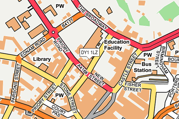
DY1 1LZ is located in the St James's electoral ward, within the metropolitan district of Dudley and the English Parliamentary constituency of Dudley North. The Sub Integrated Care Board (ICB) Location is NHS Black Country ICB - D2P2L and the police force is West Midlands. This postcode has been in use since April 2017.


GetTheData
Source: OS OpenMap – Local (Ordnance Survey)
Source: OS VectorMap District (Ordnance Survey)
Licence: Open Government Licence (requires attribution)
| Easting | 394468 |
| Northing | 290435 |
| Latitude | 52.511961 |
| Longitude | -2.082790 |
GetTheData
Source: Open Postcode Geo
Licence: Open Government Licence
| Country | England |
| Postcode District | DY1 |
➜ See where DY1 is on a map ➜ Where is Dudley? | |
GetTheData
Source: Land Registry Price Paid Data
Licence: Open Government Licence
| Ward | St James's |
| Constituency | Dudley North |
GetTheData
Source: ONS Postcode Database
Licence: Open Government Licence
| Priory St (New St) | Dudley | 31m |
| Tower St (New St) | Dudley | 53m |
| St Edmunds Church (Castle St) | Dudley | 137m |
| Tower St (The Broadway) | Dudley | 140m |
| Priory St | Dudley | 143m |
| Tipton Station | 2.4km |
| Dudley Port Station | 2.7km |
| Coseley Station | 3.7km |
GetTheData
Source: NaPTAN
Licence: Open Government Licence
GetTheData
Source: ONS Postcode Database
Licence: Open Government Licence


➜ Get more ratings from the Food Standards Agency
GetTheData
Source: Food Standards Agency
Licence: FSA terms & conditions
| Last Collection | |||
|---|---|---|---|
| Location | Mon-Fri | Sat | Distance |
| High Street | 18:30 | 11:00 | 186m |
| Dudley Post Office | 19:00 | 12:00 | 371m |
| Hall Street | 17:30 | 11:00 | 632m |
GetTheData
Source: Dracos
Licence: Creative Commons Attribution-ShareAlike
The below table lists the International Territorial Level (ITL) codes (formerly Nomenclature of Territorial Units for Statistics (NUTS) codes) and Local Administrative Units (LAU) codes for DY1 1LZ:
| ITL 1 Code | Name |
|---|---|
| TLG | West Midlands (England) |
| ITL 2 Code | Name |
| TLG3 | West Midlands |
| ITL 3 Code | Name |
| TLG36 | Dudley |
| LAU 1 Code | Name |
| E08000027 | Dudley |
GetTheData
Source: ONS Postcode Directory
Licence: Open Government Licence
The below table lists the Census Output Area (OA), Lower Layer Super Output Area (LSOA), and Middle Layer Super Output Area (MSOA) for DY1 1LZ:
| Code | Name | |
|---|---|---|
| OA | E00049383 | |
| LSOA | E01009757 | Dudley 006C |
| MSOA | E02002005 | Dudley 006 |
GetTheData
Source: ONS Postcode Directory
Licence: Open Government Licence
| DY1 1LU | New Street | 30m |
| DY1 1LP | New Street | 59m |
| DY1 1LT | New Street | 69m |
| DY1 1NJ | Stone Street | 91m |
| DY1 1NB | Tower Street | 103m |
| DY1 1LQ | Castle Street | 109m |
| DY1 1PQ | High Street | 113m |
| DY1 1HA | Priory Street | 140m |
| DY1 1LA | Castle Street | 145m |
| DY1 4AN | The Broadway | 148m |
GetTheData
Source: Open Postcode Geo; Land Registry Price Paid Data
Licence: Open Government Licence