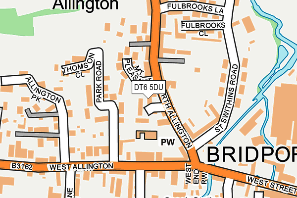
DT6 5DU lies on North Allington in Bridport. DT6 5DU is located in the Bridport electoral ward, within the unitary authority of Dorset and the English Parliamentary constituency of West Dorset. The Sub Integrated Care Board (ICB) Location is NHS Dorset ICB - 11J and the police force is Dorset. This postcode has been in use since December 2000.


GetTheData
Source: OS OpenMap – Local (Ordnance Survey)
Source: OS VectorMap District (Ordnance Survey)
Licence: Open Government Licence (requires attribution)
| Easting | 346135 |
| Northing | 93167 |
| Latitude | 50.735595 |
| Longitude | -2.764658 |
GetTheData
Source: Open Postcode Geo
Licence: Open Government Licence
| Street | North Allington |
| Town/City | Bridport |
| Country | England |
| Postcode District | DT6 |
➜ See where DT6 is on a map ➜ Where is Bridport? | |
GetTheData
Source: Land Registry Price Paid Data
Licence: Open Government Licence
Elevation or altitude of DT6 5DU as distance above sea level:
| Metres | Feet | |
|---|---|---|
| Elevation | 10m | 33ft |
Elevation is measured from the approximate centre of the postcode, to the nearest point on an OS contour line from OS Terrain 50, which has contour spacing of ten vertical metres.
➜ How high above sea level am I? Find the elevation of your current position using your device's GPS.
GetTheData
Source: Open Postcode Elevation
Licence: Open Government Licence
| Ward | Bridport |
| Constituency | West Dorset |
GetTheData
Source: ONS Postcode Database
Licence: Open Government Licence
ST. SWITHINS HOUSE, NORTH ALLINGTON, BRIDPORT, DT6 5DU 2006 21 DEC £238,000 |
ST. SWITHINS HOUSE, NORTH ALLINGTON, BRIDPORT, DT6 5DU 2006 3 FEB £285,000 |
GetTheData
Source: HM Land Registry Price Paid Data
Licence: Contains HM Land Registry data © Crown copyright and database right 2025. This data is licensed under the Open Government Licence v3.0.
| Park Road (West Allington) | West Allington | 142m |
| St Swithins Road | Allington | 155m |
| Park Road (West Allington) | West Allington | 184m |
| Fulbrooks Lane (St Swithins Road) | Allington | 221m |
| Fulbrooks Lane (St Swithins Road) | Allington | 235m |
GetTheData
Source: NaPTAN
Licence: Open Government Licence
GetTheData
Source: ONS Postcode Database
Licence: Open Government Licence


➜ Get more ratings from the Food Standards Agency
GetTheData
Source: Food Standards Agency
Licence: FSA terms & conditions
| Last Collection | |||
|---|---|---|---|
| Location | Mon-Fri | Sat | Distance |
| Bridport L D O | 18:00 | 12:15 | 411m |
| North Allington | 16:00 | 12:00 | 436m |
| Victoria Grove | 16:00 | 12:00 | 588m |
GetTheData
Source: Dracos
Licence: Creative Commons Attribution-ShareAlike
The below table lists the International Territorial Level (ITL) codes (formerly Nomenclature of Territorial Units for Statistics (NUTS) codes) and Local Administrative Units (LAU) codes for DT6 5DU:
| ITL 1 Code | Name |
|---|---|
| TLK | South West (England) |
| ITL 2 Code | Name |
| TLK2 | Dorset and Somerset |
| ITL 3 Code | Name |
| TLK25 | Dorset |
| LAU 1 Code | Name |
| E06000059 | Dorset |
GetTheData
Source: ONS Postcode Directory
Licence: Open Government Licence
The below table lists the Census Output Area (OA), Lower Layer Super Output Area (LSOA), and Middle Layer Super Output Area (MSOA) for DT6 5DU:
| Code | Name | |
|---|---|---|
| OA | E00103938 | |
| LSOA | E01020500 | West Dorset 006C |
| MSOA | E02004274 | West Dorset 006 |
GetTheData
Source: ONS Postcode Directory
Licence: Open Government Licence
| DT6 5FD | St Swithins Place | 26m |
| DT6 5FJ | The Linen Yard | 46m |
| DT6 5DX | North Allington | 48m |
| DT6 5DY | North Allington | 49m |
| DT6 5EJ | Sunnybank | 62m |
| DT6 5EL | Mount Pleasant | 71m |
| DT6 5EN | Portland Place | 110m |
| DT6 5BG | West Allington | 120m |
| DT6 5DA | Park Road | 122m |
| DT6 5DG | St Swithins Road | 124m |
GetTheData
Source: Open Postcode Geo; Land Registry Price Paid Data
Licence: Open Government Licence