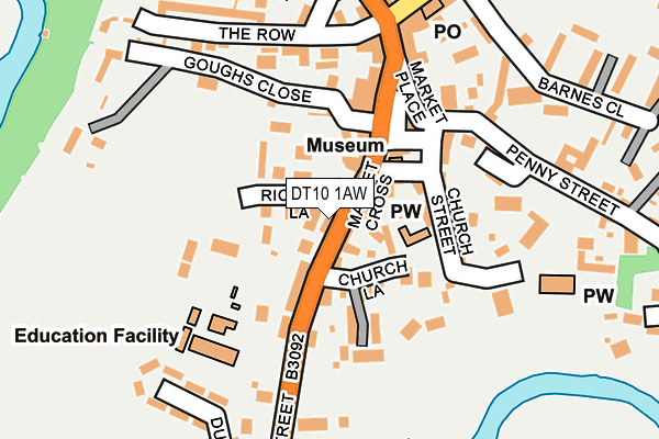
DT10 1AW lies on Bridge Street in Sturminster Newton. DT10 1AW is located in the Sturminster Newton electoral ward, within the unitary authority of Dorset and the English Parliamentary constituency of North Dorset. The Sub Integrated Care Board (ICB) Location is NHS Dorset ICB - 11J and the police force is Dorset. This postcode has been in use since January 1980.


GetTheData
Source: OS OpenMap – Local (Ordnance Survey)
Source: OS VectorMap District (Ordnance Survey)
Licence: Open Government Licence (requires attribution)
| Easting | 378598 |
| Northing | 114008 |
| Latitude | 50.925118 |
| Longitude | -2.305874 |
GetTheData
Source: Open Postcode Geo
Licence: Open Government Licence
| Street | Bridge Street |
| Town/City | Sturminster Newton |
| Country | England |
| Postcode District | DT10 |
➜ See where DT10 is on a map ➜ Where is Sturminster Newton? | |
GetTheData
Source: Land Registry Price Paid Data
Licence: Open Government Licence
Elevation or altitude of DT10 1AW as distance above sea level:
| Metres | Feet | |
|---|---|---|
| Elevation | 60m | 197ft |
Elevation is measured from the approximate centre of the postcode, to the nearest point on an OS contour line from OS Terrain 50, which has contour spacing of ten vertical metres.
➜ How high above sea level am I? Find the elevation of your current position using your device's GPS.
GetTheData
Source: Open Postcode Elevation
Licence: Open Government Licence
| Ward | Sturminster Newton |
| Constituency | North Dorset |
GetTheData
Source: ONS Postcode Database
Licence: Open Government Licence
| Minster House (Bridge Street) | Sturminster Newton | 139m |
| Minster House (Bridge Street) | The Bridge | 152m |
| Car Park (Barnes Close) | Sturminster Newton | 237m |
| Car Park (Barnes Close) | Sturminster Newton | 243m |
| The Library (Bath Road) | Sturminster Newton | 254m |
GetTheData
Source: NaPTAN
Licence: Open Government Licence
GetTheData
Source: ONS Postcode Database
Licence: Open Government Licence


➜ Get more ratings from the Food Standards Agency
GetTheData
Source: Food Standards Agency
Licence: FSA terms & conditions
| Last Collection | |||
|---|---|---|---|
| Location | Mon-Fri | Sat | Distance |
| Oakford Fitzpaine P.o. | 16:00 | 09:00 | 3,653m |
| Higher Fifehead | 15:15 | 10:30 | 4,347m |
| Sturminster Newton Road | 09:00 | 09:00 | 5,551m |
GetTheData
Source: Dracos
Licence: Creative Commons Attribution-ShareAlike
The below table lists the International Territorial Level (ITL) codes (formerly Nomenclature of Territorial Units for Statistics (NUTS) codes) and Local Administrative Units (LAU) codes for DT10 1AW:
| ITL 1 Code | Name |
|---|---|
| TLK | South West (England) |
| ITL 2 Code | Name |
| TLK2 | Dorset and Somerset |
| ITL 3 Code | Name |
| TLK25 | Dorset |
| LAU 1 Code | Name |
| E06000059 | Dorset |
GetTheData
Source: ONS Postcode Directory
Licence: Open Government Licence
The below table lists the Census Output Area (OA), Lower Layer Super Output Area (LSOA), and Middle Layer Super Output Area (MSOA) for DT10 1AW:
| Code | Name | |
|---|---|---|
| OA | E00103706 | |
| LSOA | E01020459 | North Dorset 004E |
| MSOA | E02004258 | North Dorset 004 |
GetTheData
Source: ONS Postcode Directory
Licence: Open Government Licence
| DT10 1LX | Red Rose Court | 40m |
| DT10 1BY | Ricketts Lane | 47m |
| DT10 1AN | Market Cross | 60m |
| DT10 1BZ | Bridge Street | 69m |
| DT10 1DH | Church Lane | 86m |
| DT10 1FE | Church Lane | 107m |
| DT10 1DB | Church Street | 109m |
| DT10 1BU | Goughs Close | 118m |
| DT10 1AS | Market Place | 138m |
| DT10 1AR | Market Place | 141m |
GetTheData
Source: Open Postcode Geo; Land Registry Price Paid Data
Licence: Open Government Licence