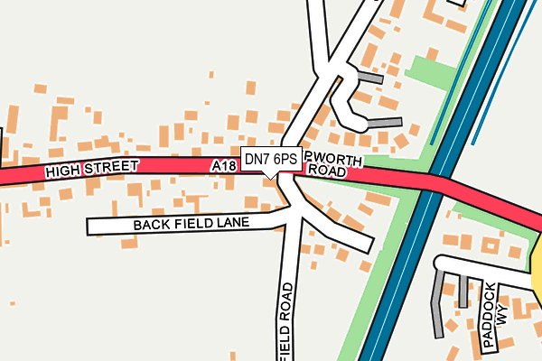
DN7 6PS is located in the Hatfield electoral ward, within the metropolitan district of Doncaster and the English Parliamentary constituency of Don Valley. The Sub Integrated Care Board (ICB) Location is NHS South Yorkshire ICB - 02X and the police force is South Yorkshire. This postcode has been in use since April 2017.


GetTheData
Source: OS OpenMap – Local (Ordnance Survey)
Source: OS VectorMap District (Ordnance Survey)
Licence: Open Government Licence (requires attribution)
| Easting | 466879 |
| Northing | 409421 |
| Latitude | 53.577152 |
| Longitude | -0.991419 |
GetTheData
Source: Open Postcode Geo
Licence: Open Government Licence
| Country | England |
| Postcode District | DN7 |
➜ See where DN7 is on a map ➜ Where is Hatfield? | |
GetTheData
Source: Land Registry Price Paid Data
Licence: Open Government Licence
| Ward | Hatfield |
| Constituency | Don Valley |
GetTheData
Source: ONS Postcode Database
Licence: Open Government Licence
2021 16 APR £490,000 |
2017 21 JUN £84,000 |
GetTheData
Source: HM Land Registry Price Paid Data
Licence: Contains HM Land Registry data © Crown copyright and database right 2024. This data is licensed under the Open Government Licence v3.0.
| Old Thorne Road (High Street) | Hatfield | 162m |
| Epworth Road (High Street) | Hatfield | 169m |
| Epworth Road (Cemetery Road) | Hatfield | 218m |
| Cemetery Road (Epworth Road) | Hatfield | 254m |
| Old Epworth Road East (Cemetery Road) | Hatfield Woodhouse | 264m |
| Hatfield & Stainforth Station | 2.5km |
| Thorne South Station | 3.8km |
| Thorne North Station | 4.5km |
GetTheData
Source: NaPTAN
Licence: Open Government Licence
| Percentage of properties with Next Generation Access | 100.0% |
| Percentage of properties with Superfast Broadband | 100.0% |
| Percentage of properties with Ultrafast Broadband | 0.0% |
| Percentage of properties with Full Fibre Broadband | 0.0% |
Superfast Broadband is between 30Mbps and 300Mbps
Ultrafast Broadband is > 300Mbps
| Percentage of properties unable to receive 2Mbps | 0.0% |
| Percentage of properties unable to receive 5Mbps | 0.0% |
| Percentage of properties unable to receive 10Mbps | 0.0% |
| Percentage of properties unable to receive 30Mbps | 0.0% |
GetTheData
Source: Ofcom
Licence: Ofcom Terms of Use (requires attribution)
GetTheData
Source: ONS Postcode Database
Licence: Open Government Licence


➜ Get more ratings from the Food Standards Agency
GetTheData
Source: Food Standards Agency
Licence: FSA terms & conditions
| Last Collection | |||
|---|---|---|---|
| Location | Mon-Fri | Sat | Distance |
| Hatfield Post Office | 16:30 | 11:15 | 593m |
| East End | 16:00 | 07:45 | 652m |
| South End | 16:00 | 09:00 | 1,069m |
GetTheData
Source: Dracos
Licence: Creative Commons Attribution-ShareAlike
The below table lists the International Territorial Level (ITL) codes (formerly Nomenclature of Territorial Units for Statistics (NUTS) codes) and Local Administrative Units (LAU) codes for DN7 6PS:
| ITL 1 Code | Name |
|---|---|
| TLE | Yorkshire and The Humber |
| ITL 2 Code | Name |
| TLE3 | South Yorkshire |
| ITL 3 Code | Name |
| TLE31 | Barnsley, Doncaster and Rotherham |
| LAU 1 Code | Name |
| E08000017 | Doncaster |
GetTheData
Source: ONS Postcode Directory
Licence: Open Government Licence
The below table lists the Census Output Area (OA), Lower Layer Super Output Area (LSOA), and Middle Layer Super Output Area (MSOA) for DN7 6PS:
| Code | Name | |
|---|---|---|
| OA | E00038289 | |
| LSOA | E01007553 | Doncaster 008A |
| MSOA | E02001546 | Doncaster 008 |
GetTheData
Source: ONS Postcode Directory
Licence: Open Government Licence
| DN7 6LP | Old Epworth Road | 38m |
| DN7 6BS | Abbeyfield Court | 131m |
| DN7 6LS | Old Epworth Road | 148m |
| DN7 6LR | New Mill Field Road | 180m |
| DN7 6DY | Paddock Way | 194m |
| DN7 6LW | Backfield Lane | 196m |
| DN7 6ER | Old Thorne Road | 255m |
| DN7 6ED | Mallard Chase | 342m |
| DN7 6LX | Cemetery Road | 345m |
| DN7 6LT | Cemetery Road | 371m |
GetTheData
Source: Open Postcode Geo; Land Registry Price Paid Data
Licence: Open Government Licence