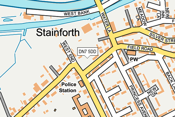
DN7 5DD is located in the Stainforth & Barnby Dun electoral ward, within the metropolitan district of Doncaster and the English Parliamentary constituency of Doncaster North. The Sub Integrated Care Board (ICB) Location is NHS South Yorkshire ICB - 02X and the police force is South Yorkshire. This postcode has been in use since January 1980.


GetTheData
Source: OS OpenMap – Local (Ordnance Survey)
Source: OS VectorMap District (Ordnance Survey)
Licence: Open Government Licence (requires attribution)
| Easting | 464059 |
| Northing | 411912 |
| Latitude | 53.599870 |
| Longitude | -1.033486 |
GetTheData
Source: Open Postcode Geo
Licence: Open Government Licence
| Country | England |
| Postcode District | DN7 |
➜ See where DN7 is on a map ➜ Where is Stainforth? | |
GetTheData
Source: Land Registry Price Paid Data
Licence: Open Government Licence
Elevation or altitude of DN7 5DD as distance above sea level:
| Metres | Feet | |
|---|---|---|
| Elevation | 10m | 33ft |
Elevation is measured from the approximate centre of the postcode, to the nearest point on an OS contour line from OS Terrain 50, which has contour spacing of ten vertical metres.
➜ How high above sea level am I? Find the elevation of your current position using your device's GPS.
GetTheData
Source: Open Postcode Elevation
Licence: Open Government Licence
| Ward | Stainforth & Barnby Dun |
| Constituency | Doncaster North |
GetTheData
Source: ONS Postcode Database
Licence: Open Government Licence
| Church Road (Field Road) | Stainforth | 28m |
| Stainforth Police Station (Church Road) | Stainforth | 82m |
| The Fox (Field Road) | Stainforth | 133m |
| Princess Avenue (Field Road) | Stainforth | 154m |
| Water Lane (Silver Street) | Stainforth | 162m |
| Hatfield & Stainforth Station | 1.4km |
| Thorne North Station | 4.4km |
| Kirk Sandall Station | 4.8km |
GetTheData
Source: NaPTAN
Licence: Open Government Licence
Estimated total energy consumption in DN7 5DD by fuel type, 2015.
| Consumption (kWh) | 61,623 |
|---|---|
| Meter count | 9 |
| Mean (kWh/meter) | 6,847 |
| Median (kWh/meter) | 4,823 |
GetTheData
Source: Postcode level gas estimates: 2015 (experimental)
Source: Postcode level electricity estimates: 2015 (experimental)
Licence: Open Government Licence
GetTheData
Source: ONS Postcode Database
Licence: Open Government Licence


➜ Get more ratings from the Food Standards Agency
GetTheData
Source: Food Standards Agency
Licence: FSA terms & conditions
| Last Collection | |||
|---|---|---|---|
| Location | Mon-Fri | Sat | Distance |
| West End | 16:45 | 10:00 | 63m |
| East Lane | 16:30 | 10:00 | 500m |
| Thorne Road | 17:00 | 09:30 | 683m |
GetTheData
Source: Dracos
Licence: Creative Commons Attribution-ShareAlike
| Risk of DN7 5DD flooding from rivers and sea | Medium |
| ➜ DN7 5DD flood map | |
GetTheData
Source: Open Flood Risk by Postcode
Licence: Open Government Licence
The below table lists the International Territorial Level (ITL) codes (formerly Nomenclature of Territorial Units for Statistics (NUTS) codes) and Local Administrative Units (LAU) codes for DN7 5DD:
| ITL 1 Code | Name |
|---|---|
| TLE | Yorkshire and The Humber |
| ITL 2 Code | Name |
| TLE3 | South Yorkshire |
| ITL 3 Code | Name |
| TLE31 | Barnsley, Doncaster and Rotherham |
| LAU 1 Code | Name |
| E08000017 | Doncaster |
GetTheData
Source: ONS Postcode Directory
Licence: Open Government Licence
The below table lists the Census Output Area (OA), Lower Layer Super Output Area (LSOA), and Middle Layer Super Output Area (MSOA) for DN7 5DD:
| Code | Name | |
|---|---|---|
| OA | E00038653 | |
| LSOA | E01007626 | Doncaster 004B |
| MSOA | E02001542 | Doncaster 004 |
GetTheData
Source: ONS Postcode Directory
Licence: Open Government Licence
| DN7 5RH | First Square | 83m |
| DN7 5JD | Hall Road | 120m |
| DN7 5SF | Doncaster Road | 141m |
| DN7 5RQ | Second Square | 163m |
| DN7 5RG | Princess Avenue | 171m |
| DN7 5SB | Doncaster Road | 191m |
| DN7 5AQ | Field Road | 198m |
| DN7 5SE | Doncaster Road | 204m |
| DN7 5AE | Church Road | 217m |
| DN7 5AN | Meadow Lane | 229m |
GetTheData
Source: Open Postcode Geo; Land Registry Price Paid Data
Licence: Open Government Licence