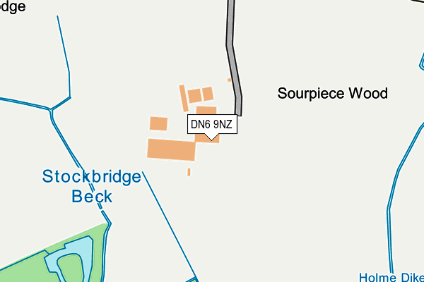
DN6 9NZ is located in the Norton & Askern electoral ward, within the metropolitan district of Doncaster and the English Parliamentary constituency of Doncaster North. The Sub Integrated Care Board (ICB) Location is NHS South Yorkshire ICB - 02X and the police force is South Yorkshire. This postcode has been in use since April 2017.


GetTheData
Source: OS OpenMap – Local (Ordnance Survey)
Source: OS VectorMap District (Ordnance Survey)
Licence: Open Government Licence (requires attribution)
| Easting | 456022 |
| Northing | 411214 |
| Latitude | 53.594535 |
| Longitude | -1.155045 |
GetTheData
Source: Open Postcode Geo
Licence: Open Government Licence
| Country | England |
| Postcode District | DN6 |
➜ See where DN6 is on a map | |
GetTheData
Source: Land Registry Price Paid Data
Licence: Open Government Licence
| Ward | Norton & Askern |
| Constituency | Doncaster North |
GetTheData
Source: ONS Postcode Database
Licence: Open Government Licence
| Doncaster Road (Sutton Road) | Owston | 498m |
| Doncaster Road (Sutton Road) | Owston | 532m |
| Askern Road (Doncaster Road) | Toll Bar | 651m |
| Askern Road (Doncaster Road) | Toll Bar | 684m |
| Holme Lane (Doncaster Road) | Toll Bar | 1,013m |
| Adwick Station | 3km |
GetTheData
Source: NaPTAN
Licence: Open Government Licence
| Percentage of properties with Next Generation Access | 100.0% |
| Percentage of properties with Superfast Broadband | 0.0% |
| Percentage of properties with Ultrafast Broadband | 0.0% |
| Percentage of properties with Full Fibre Broadband | 0.0% |
Superfast Broadband is between 30Mbps and 300Mbps
Ultrafast Broadband is > 300Mbps
| Percentage of properties unable to receive 2Mbps | 100.0% |
| Percentage of properties unable to receive 5Mbps | 100.0% |
| Percentage of properties unable to receive 10Mbps | 100.0% |
| Percentage of properties unable to receive 30Mbps | 100.0% |
GetTheData
Source: Ofcom
Licence: Ofcom Terms of Use (requires attribution)
GetTheData
Source: ONS Postcode Database
Licence: Open Government Licence


➜ Get more ratings from the Food Standards Agency
GetTheData
Source: Food Standards Agency
Licence: FSA terms & conditions
| Last Collection | |||
|---|---|---|---|
| Location | Mon-Fri | Sat | Distance |
| Owston | 17:15 | 07:45 | 980m |
| Sutton | 17:15 | 09:30 | 1,469m |
| Instoneville P.o. | 17:00 | 11:15 | 1,820m |
GetTheData
Source: Dracos
Licence: Creative Commons Attribution-ShareAlike
| Risk of DN6 9NZ flooding from rivers and sea | Low |
| ➜ DN6 9NZ flood map | |
GetTheData
Source: Open Flood Risk by Postcode
Licence: Open Government Licence
The below table lists the International Territorial Level (ITL) codes (formerly Nomenclature of Territorial Units for Statistics (NUTS) codes) and Local Administrative Units (LAU) codes for DN6 9NZ:
| ITL 1 Code | Name |
|---|---|
| TLE | Yorkshire and The Humber |
| ITL 2 Code | Name |
| TLE3 | South Yorkshire |
| ITL 3 Code | Name |
| TLE31 | Barnsley, Doncaster and Rotherham |
| LAU 1 Code | Name |
| E08000017 | Doncaster |
GetTheData
Source: ONS Postcode Directory
Licence: Open Government Licence
The below table lists the Census Output Area (OA), Lower Layer Super Output Area (LSOA), and Middle Layer Super Output Area (MSOA) for DN6 9NZ:
| Code | Name | |
|---|---|---|
| OA | E00037977 | |
| LSOA | E01007488 | Doncaster 002B |
| MSOA | E02001540 | Doncaster 002 |
GetTheData
Source: ONS Postcode Directory
Licence: Open Government Licence
| DN6 9JE | Doncaster Road | 468m |
| DN6 9JG | 559m | |
| DN5 0LR | Holme Lane | 710m |
| DN6 9JD | Doncaster Road | 742m |
| DN5 0LP | 857m | |
| DN6 9JB | Doncaster Road | 867m |
| DN6 9JF | 991m | |
| DN6 9LA | Main Street | 1463m |
| DN6 9LB | Main Street | 1490m |
| DN6 8EF | Owston Lane | 1505m |
GetTheData
Source: Open Postcode Geo; Land Registry Price Paid Data
Licence: Open Government Licence