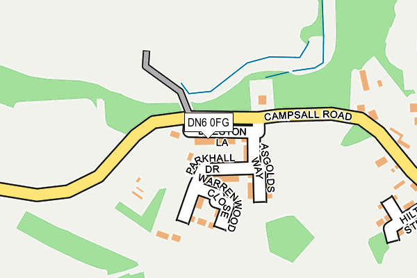
DN6 0FG is located in the Norton & Askern electoral ward, within the metropolitan district of Doncaster and the English Parliamentary constituency of Doncaster North. The Sub Integrated Care Board (ICB) Location is NHS South Yorkshire ICB - 02X and the police force is South Yorkshire. This postcode has been in use since March 2017.


GetTheData
Source: OS OpenMap – Local (Ordnance Survey)
Source: OS VectorMap District (Ordnance Survey)
Licence: Open Government Licence (requires attribution)
| Easting | 455751 |
| Northing | 413926 |
| Latitude | 53.618937 |
| Longitude | -1.158655 |
GetTheData
Source: Open Postcode Geo
Licence: Open Government Licence
| Country | England |
| Postcode District | DN6 |
➜ See where DN6 is on a map ➜ Where is Askern? | |
GetTheData
Source: Land Registry Price Paid Data
Licence: Open Government Licence
| Ward | Norton & Askern |
| Constituency | Doncaster North |
GetTheData
Source: ONS Postcode Database
Licence: Open Government Licence
| Hilton Street (Campsall Road) | Askern | 26m |
| Hilton Street (Campsall Road) | Askern | 38m |
| O/S Askern Cemetery (Church Field Road) | Askern | 325m |
| Opp Askern Cemetery (Church Field Road) | Askern | 337m |
| Campsall Road (Selby Road) | Askern | 417m |
GetTheData
Source: NaPTAN
Licence: Open Government Licence
| Percentage of properties with Next Generation Access | 0.0% |
| Percentage of properties with Superfast Broadband | 0.0% |
| Percentage of properties with Ultrafast Broadband | 0.0% |
| Percentage of properties with Full Fibre Broadband | 0.0% |
Superfast Broadband is between 30Mbps and 300Mbps
Ultrafast Broadband is > 300Mbps
| Median download speed | 19.2Mbps |
| Average download speed | 18.6Mbps |
| Maximum download speed | 20.22Mbps |
| Median upload speed | 1.1Mbps |
| Average upload speed | 1.1Mbps |
| Maximum upload speed | 1.26Mbps |
| Percentage of properties unable to receive 2Mbps | 0.0% |
| Percentage of properties unable to receive 5Mbps | 0.0% |
| Percentage of properties unable to receive 10Mbps | 0.0% |
| Percentage of properties unable to receive 30Mbps | 100.0% |
GetTheData
Source: Ofcom
Licence: Ofcom Terms of Use (requires attribution)
GetTheData
Source: ONS Postcode Database
Licence: Open Government Licence


➜ Get more ratings from the Food Standards Agency
GetTheData
Source: Food Standards Agency
Licence: FSA terms & conditions
| Last Collection | |||
|---|---|---|---|
| Location | Mon-Fri | Sat | Distance |
| Askern Post Office | 16:45 | 11:30 | 496m |
| Avenue Road | 17:00 | 08:15 | 607m |
| Instoneville P.o. | 17:00 | 11:15 | 916m |
GetTheData
Source: Dracos
Licence: Creative Commons Attribution-ShareAlike
The below table lists the International Territorial Level (ITL) codes (formerly Nomenclature of Territorial Units for Statistics (NUTS) codes) and Local Administrative Units (LAU) codes for DN6 0FG:
| ITL 1 Code | Name |
|---|---|
| TLE | Yorkshire and The Humber |
| ITL 2 Code | Name |
| TLE3 | South Yorkshire |
| ITL 3 Code | Name |
| TLE31 | Barnsley, Doncaster and Rotherham |
| LAU 1 Code | Name |
| E08000017 | Doncaster |
GetTheData
Source: ONS Postcode Directory
Licence: Open Government Licence
The below table lists the Census Output Area (OA), Lower Layer Super Output Area (LSOA), and Middle Layer Super Output Area (MSOA) for DN6 0FG:
| Code | Name | |
|---|---|---|
| OA | E00037953 | |
| LSOA | E01007489 | Doncaster 002C |
| MSOA | E02001540 | Doncaster 002 |
GetTheData
Source: ONS Postcode Directory
Licence: Open Government Licence
| DN6 0BY | Campsall Road | 223m |
| DN6 0ER | Selby Road | 307m |
| DN6 0BX | Hilton Street | 313m |
| DN6 0BT | Campsall Road | 315m |
| DN6 0QP | Avenue Road | 437m |
| DN6 0PL | St Peters Terrace | 443m |
| DN6 0QT | Swan Court | 448m |
| DN6 0PN | Westfield Terrace | 457m |
| DN6 0QX | Swan Court | 470m |
| DN6 0QU | Swan Court | 487m |
GetTheData
Source: Open Postcode Geo; Land Registry Price Paid Data
Licence: Open Government Licence