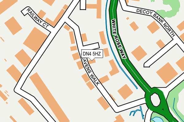
DN4 5HZ lies on Heavens Walk in Doncaster. DN4 5HZ is located in the Hexthorpe & Balby North electoral ward, within the metropolitan district of Doncaster and the English Parliamentary constituency of Doncaster Central. The Sub Integrated Care Board (ICB) Location is NHS South Yorkshire ICB - 02X and the police force is South Yorkshire. This postcode has been in use since January 1992.


GetTheData
Source: OS OpenMap – Local (Ordnance Survey)
Source: OS VectorMap District (Ordnance Survey)
Licence: Open Government Licence (requires attribution)
| Easting | 457733 |
| Northing | 401965 |
| Latitude | 53.511207 |
| Longitude | -1.130898 |
GetTheData
Source: Open Postcode Geo
Licence: Open Government Licence
| Street | Heavens Walk |
| Town/City | Doncaster |
| Country | England |
| Postcode District | DN4 |
➜ See where DN4 is on a map ➜ Where is Doncaster? | |
GetTheData
Source: Land Registry Price Paid Data
Licence: Open Government Licence
Elevation or altitude of DN4 5HZ as distance above sea level:
| Metres | Feet | |
|---|---|---|
| Elevation | 10m | 33ft |
Elevation is measured from the approximate centre of the postcode, to the nearest point on an OS contour line from OS Terrain 50, which has contour spacing of ten vertical metres.
➜ How high above sea level am I? Find the elevation of your current position using your device's GPS.
GetTheData
Source: Open Postcode Elevation
Licence: Open Government Licence
| Ward | Hexthorpe & Balby North |
| Constituency | Doncaster Central |
GetTheData
Source: ONS Postcode Database
Licence: Open Government Licence
LUCAS, HEAVENS WALK, DONCASTER, DN4 5HZ 2009 12 FEB £250,000 |
GetTheData
Source: HM Land Registry Price Paid Data
Licence: Contains HM Land Registry data © Crown copyright and database right 2025. This data is licensed under the Open Government Licence v3.0.
| White Rose Way (Heavens Walk) | Hyde Park | 42m |
| White Rose Way (Heavens Walk) | Hyde Park | 198m |
| Heavens Walk (Ten Pound Walk) | Hyde Park | 211m |
| White Rose Way (Middle Bank) | Hyde Park | 323m |
| Lady Bank Drive (Middle Bank) | Hyde Park | 440m |
| Doncaster Station | 1.4km |
| Bentley (S Yorks) Station | 3.9km |
GetTheData
Source: NaPTAN
Licence: Open Government Licence
Estimated total energy consumption in DN4 5HZ by fuel type, 2015.
| Consumption (kWh) | 506,864 |
|---|---|
| Meter count | 14 |
| Mean (kWh/meter) | 36,205 |
| Median (kWh/meter) | 34,225 |
GetTheData
Source: Postcode level gas estimates: 2015 (experimental)
Source: Postcode level electricity estimates: 2015 (experimental)
Licence: Open Government Licence
GetTheData
Source: ONS Postcode Database
Licence: Open Government Licence

➜ Get more ratings from the Food Standards Agency
GetTheData
Source: Food Standards Agency
Licence: FSA terms & conditions
| Last Collection | |||
|---|---|---|---|
| Location | Mon-Fri | Sat | Distance |
| Nelson Street Industrial Est | 17:00 | 12:00 | 404m |
| Doncaster Mail Centre | 19:30 | 13:30 | 448m |
| Hyde Park Post Office | 18:30 | 11:30 | 556m |
GetTheData
Source: Dracos
Licence: Creative Commons Attribution-ShareAlike
The below table lists the International Territorial Level (ITL) codes (formerly Nomenclature of Territorial Units for Statistics (NUTS) codes) and Local Administrative Units (LAU) codes for DN4 5HZ:
| ITL 1 Code | Name |
|---|---|
| TLE | Yorkshire and The Humber |
| ITL 2 Code | Name |
| TLE3 | South Yorkshire |
| ITL 3 Code | Name |
| TLE31 | Barnsley, Doncaster and Rotherham |
| LAU 1 Code | Name |
| E08000017 | Doncaster |
GetTheData
Source: ONS Postcode Directory
Licence: Open Government Licence
The below table lists the Census Output Area (OA), Lower Layer Super Output Area (LSOA), and Middle Layer Super Output Area (MSOA) for DN4 5HZ:
| Code | Name | |
|---|---|---|
| OA | E00038157 | |
| LSOA | E01007534 | Doncaster 028D |
| MSOA | E02001566 | Doncaster 028 |
GetTheData
Source: ONS Postcode Directory
Licence: Open Government Licence
| DN4 5HX | Ten Pound Walk | 146m |
| DN4 5AE | South Street | 420m |
| DN4 5AG | St Andrews Terrace | 442m |
| DN4 5AQ | North Street | 467m |
| DN4 5DF | Cooper Street | 480m |
| DN4 5FH | South Street | 492m |
| DN1 3QW | Exchange Street | 511m |
| DN4 5FJ | North Street | 517m |
| DN1 3QJ | Milton Walk | 525m |
| DN1 3TR | Holly Street | 531m |
GetTheData
Source: Open Postcode Geo; Land Registry Price Paid Data
Licence: Open Government Licence