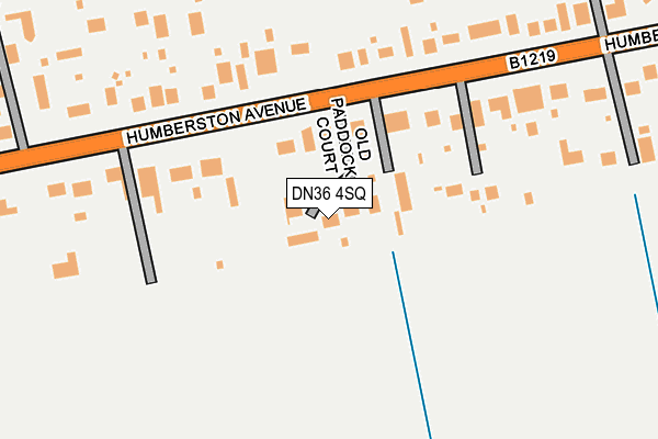
DN36 4SQ lies on Old Paddock Court in Humberston, Grimsby. DN36 4SQ is located in the Humberston and New Waltham electoral ward, within the unitary authority of North East Lincolnshire and the English Parliamentary constituency of Cleethorpes. The Sub Integrated Care Board (ICB) Location is NHS Humber and North Yorkshire ICB - 03H and the police force is Humberside. This postcode has been in use since May 2005.


GetTheData
Source: OS OpenMap – Local (Ordnance Survey)
Source: OS VectorMap District (Ordnance Survey)
Licence: Open Government Licence (requires attribution)
| Easting | 529563 |
| Northing | 404880 |
| Latitude | 53.524619 |
| Longitude | -0.047050 |
GetTheData
Source: Open Postcode Geo
Licence: Open Government Licence
| Street | Old Paddock Court |
| Locality | Humberston |
| Town/City | Grimsby |
| Country | England |
| Postcode District | DN36 |
➜ See where DN36 is on a map ➜ Where is New Waltham? | |
GetTheData
Source: Land Registry Price Paid Data
Licence: Open Government Licence
Elevation or altitude of DN36 4SQ as distance above sea level:
| Metres | Feet | |
|---|---|---|
| Elevation | 10m | 33ft |
Elevation is measured from the approximate centre of the postcode, to the nearest point on an OS contour line from OS Terrain 50, which has contour spacing of ten vertical metres.
➜ How high above sea level am I? Find the elevation of your current position using your device's GPS.
GetTheData
Source: Open Postcode Elevation
Licence: Open Government Licence
| Ward | Humberston And New Waltham |
| Constituency | Cleethorpes |
GetTheData
Source: ONS Postcode Database
Licence: Open Government Licence
| Old Paddock Court (Humberston Avenue) | New Waltham | 114m |
| Old Paddock Court (Humberston Avenue) | New Waltham | 122m |
| Humberston Avenue | New Waltham | 271m |
| Abbotts Grange (Humberston Avenue) | New Waltham | 281m |
| Humberston Avenue | New Waltham | 282m |
| Cleethorpes Station | 4.3km |
| Grimsby Town Station | 5.1km |
GetTheData
Source: NaPTAN
Licence: Open Government Licence
| Percentage of properties with Next Generation Access | 100.0% |
| Percentage of properties with Superfast Broadband | 100.0% |
| Percentage of properties with Ultrafast Broadband | 0.0% |
| Percentage of properties with Full Fibre Broadband | 0.0% |
Superfast Broadband is between 30Mbps and 300Mbps
Ultrafast Broadband is > 300Mbps
| Median download speed | 39.0Mbps |
| Average download speed | 39.4Mbps |
| Maximum download speed | 55.00Mbps |
| Median upload speed | 8.2Mbps |
| Average upload speed | 7.3Mbps |
| Maximum upload speed | 10.46Mbps |
| Percentage of properties unable to receive 2Mbps | 0.0% |
| Percentage of properties unable to receive 5Mbps | 0.0% |
| Percentage of properties unable to receive 10Mbps | 0.0% |
| Percentage of properties unable to receive 30Mbps | 0.0% |
GetTheData
Source: Ofcom
Licence: Ofcom Terms of Use (requires attribution)
GetTheData
Source: ONS Postcode Database
Licence: Open Government Licence


➜ Get more ratings from the Food Standards Agency
GetTheData
Source: Food Standards Agency
Licence: FSA terms & conditions
| Last Collection | |||
|---|---|---|---|
| Location | Mon-Fri | Sat | Distance |
| Humberstone Avenue | 16:15 | 11:15 | 282m |
| Tetney Road | 16:15 | 11:00 | 1,020m |
| Wilton | 17:45 | 10:45 | 1,470m |
GetTheData
Source: Dracos
Licence: Creative Commons Attribution-ShareAlike
The below table lists the International Territorial Level (ITL) codes (formerly Nomenclature of Territorial Units for Statistics (NUTS) codes) and Local Administrative Units (LAU) codes for DN36 4SQ:
| ITL 1 Code | Name |
|---|---|
| TLE | Yorkshire and The Humber |
| ITL 2 Code | Name |
| TLE1 | East Yorkshire and Northern Lincolnshire |
| ITL 3 Code | Name |
| TLE13 | North and North East Lincolnshire |
| LAU 1 Code | Name |
| E06000012 | North East Lincolnshire |
GetTheData
Source: ONS Postcode Directory
Licence: Open Government Licence
The below table lists the Census Output Area (OA), Lower Layer Super Output Area (LSOA), and Middle Layer Super Output Area (MSOA) for DN36 4SQ:
| Code | Name | |
|---|---|---|
| OA | E00066443 | |
| LSOA | E01013168 | North East Lincolnshire 022A |
| MSOA | E02002747 | North East Lincolnshire 022 |
GetTheData
Source: ONS Postcode Directory
Licence: Open Government Licence
| DN36 4SS | Humberston Avenue | 142m |
| DN36 4SR | Humberston Avenue | 184m |
| DN36 4SU | Humberston Avenue | 259m |
| DN36 4ST | Humberston Avenue | 326m |
| DN36 4TD | Abbotts Grange | 380m |
| DN36 4SP | Humberston Avenue | 382m |
| DN36 4RQ | The Cedars | 443m |
| DN36 4SW | Humberston Avenue | 471m |
| DN36 4FS | The Glade | 525m |
| DN36 4TB | Canon Oakes Court | 527m |
GetTheData
Source: Open Postcode Geo; Land Registry Price Paid Data
Licence: Open Government Licence