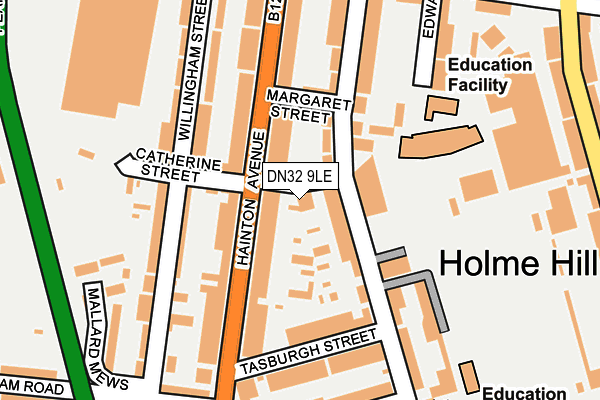
DN32 9LE lies on Catherine Street in Grimsby. DN32 9LE is located in the Heneage electoral ward, within the unitary authority of North East Lincolnshire and the English Parliamentary constituency of Great Grimsby. The Sub Integrated Care Board (ICB) Location is NHS Humber and North Yorkshire ICB - 03H and the police force is Humberside. This postcode has been in use since April 1985.


GetTheData
Source: OS OpenMap – Local (Ordnance Survey)
Source: OS VectorMap District (Ordnance Survey)
Licence: Open Government Licence (requires attribution)
| Easting | 527567 |
| Northing | 409021 |
| Latitude | 53.562331 |
| Longitude | -0.075457 |
GetTheData
Source: Open Postcode Geo
Licence: Open Government Licence
| Street | Catherine Street |
| Town/City | Grimsby |
| Country | England |
| Postcode District | DN32 |
➜ See where DN32 is on a map ➜ Where is Grimsby? | |
GetTheData
Source: Land Registry Price Paid Data
Licence: Open Government Licence
Elevation or altitude of DN32 9LE as distance above sea level:
| Metres | Feet | |
|---|---|---|
| Elevation | 10m | 33ft |
Elevation is measured from the approximate centre of the postcode, to the nearest point on an OS contour line from OS Terrain 50, which has contour spacing of ten vertical metres.
➜ How high above sea level am I? Find the elevation of your current position using your device's GPS.
GetTheData
Source: Open Postcode Elevation
Licence: Open Government Licence
| Ward | Heneage |
| Constituency | Great Grimsby |
GetTheData
Source: ONS Postcode Database
Licence: Open Government Licence
| Catherine Street (Hainton Avenue) | Weelsby | 43m |
| Catherine Street (Hainton Avenue) | Weelsby | 53m |
| Tasburgh Street (Hainton Avenue) | Weelsby | 185m |
| Tasburgh Street (Hainton Avenue) | Weelsby | 218m |
| Pasture Street (Hainton Avenue) | Weelsby | 291m |
| Grimsby Town Station | 0.8km |
| Grimsby Docks Station | 1.3km |
| New Clee Station | 1.7km |
GetTheData
Source: NaPTAN
Licence: Open Government Licence
GetTheData
Source: ONS Postcode Database
Licence: Open Government Licence


➜ Get more ratings from the Food Standards Agency
GetTheData
Source: Food Standards Agency
Licence: FSA terms & conditions
| Last Collection | |||
|---|---|---|---|
| Location | Mon-Fri | Sat | Distance |
| Hainton Avenue | 17:30 | 12:30 | 58m |
| Hare Street | 17:30 | 11:30 | 268m |
| Convamore Road | 17:30 | 11:00 | 341m |
GetTheData
Source: Dracos
Licence: Creative Commons Attribution-ShareAlike
| Risk of DN32 9LE flooding from rivers and sea | Very Low |
| ➜ DN32 9LE flood map | |
GetTheData
Source: Open Flood Risk by Postcode
Licence: Open Government Licence
The below table lists the International Territorial Level (ITL) codes (formerly Nomenclature of Territorial Units for Statistics (NUTS) codes) and Local Administrative Units (LAU) codes for DN32 9LE:
| ITL 1 Code | Name |
|---|---|
| TLE | Yorkshire and The Humber |
| ITL 2 Code | Name |
| TLE1 | East Yorkshire and Northern Lincolnshire |
| ITL 3 Code | Name |
| TLE13 | North and North East Lincolnshire |
| LAU 1 Code | Name |
| E06000012 | North East Lincolnshire |
GetTheData
Source: ONS Postcode Directory
Licence: Open Government Licence
The below table lists the Census Output Area (OA), Lower Layer Super Output Area (LSOA), and Middle Layer Super Output Area (MSOA) for DN32 9LE:
| Code | Name | |
|---|---|---|
| OA | E00066426 | |
| LSOA | E01013165 | North East Lincolnshire 011D |
| MSOA | E02002736 | North East Lincolnshire 011 |
GetTheData
Source: ONS Postcode Directory
Licence: Open Government Licence
| DN32 9JF | Heneage Road | 62m |
| DN32 9NY | Margaret Street | 85m |
| DN32 9LF | Hainton Avenue | 89m |
| DN32 9LD | Hainton Avenue | 104m |
| DN32 9LQ | Hainton Avenue | 120m |
| DN32 9JG | Heneage Road | 125m |
| DN32 9PT | Willingham Street | 134m |
| DN32 9PX | Willingham Street | 137m |
| DN32 9LJ | Hainton Avenue | 141m |
| DN32 9JQ | Heneage Road | 152m |
GetTheData
Source: Open Postcode Geo; Land Registry Price Paid Data
Licence: Open Government Licence