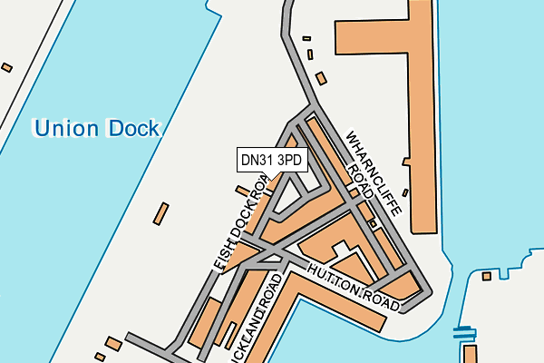
DN31 3PD is located in the East Marsh electoral ward, within the unitary authority of North East Lincolnshire and the English Parliamentary constituency of Great Grimsby. The Sub Integrated Care Board (ICB) Location is NHS Humber and North Yorkshire ICB - 03H and the police force is Humberside. This postcode has been in use since January 1980.


GetTheData
Source: OS OpenMap – Local (Ordnance Survey)
Source: OS VectorMap District (Ordnance Survey)
Licence: Open Government Licence (requires attribution)
| Easting | 527905 |
| Northing | 410956 |
| Latitude | 53.579632 |
| Longitude | -0.069567 |
GetTheData
Source: Open Postcode Geo
Licence: Open Government Licence
| Country | England |
| Postcode District | DN31 |
➜ See where DN31 is on a map ➜ Where is Grimsby? | |
GetTheData
Source: Land Registry Price Paid Data
Licence: Open Government Licence
Elevation or altitude of DN31 3PD as distance above sea level:
| Metres | Feet | |
|---|---|---|
| Elevation | 10m | 33ft |
Elevation is measured from the approximate centre of the postcode, to the nearest point on an OS contour line from OS Terrain 50, which has contour spacing of ten vertical metres.
➜ How high above sea level am I? Find the elevation of your current position using your device's GPS.
GetTheData
Source: Open Postcode Elevation
Licence: Open Government Licence
| Ward | East Marsh |
| Constituency | Great Grimsby |
GetTheData
Source: ONS Postcode Database
Licence: Open Government Licence
| Grimsby Docks (North Quay) | East Marsh | 478m |
| Tomline Street | East Marsh | 481m |
| Riby Square East-bound (Cleethorpe Road) | East Marsh | 534m |
| Riby Square West-bound (Cleethorpes Road) | East Marsh | 547m |
| Levington Street (Cleethorpes Road) | East Marsh | 624m |
| Grimsby Docks Station | 0.7km |
| New Clee Station | 0.8km |
| Grimsby Town Station | 2.1km |
GetTheData
Source: NaPTAN
Licence: Open Government Licence
GetTheData
Source: ONS Postcode Database
Licence: Open Government Licence


➜ Get more ratings from the Food Standards Agency
GetTheData
Source: Food Standards Agency
Licence: FSA terms & conditions
| Last Collection | |||
|---|---|---|---|
| Location | Mon-Fri | Sat | Distance |
| Fish Docks | 18:30 | 11:15 | 23m |
| Wickham Road | 17:00 | 11:30 | 599m |
| Cleethorpe Road | 18:30 | 12:30 | 657m |
GetTheData
Source: Dracos
Licence: Creative Commons Attribution-ShareAlike
| Risk of DN31 3PD flooding from rivers and sea | Very Low |
| ➜ DN31 3PD flood map | |
GetTheData
Source: Open Flood Risk by Postcode
Licence: Open Government Licence
The below table lists the International Territorial Level (ITL) codes (formerly Nomenclature of Territorial Units for Statistics (NUTS) codes) and Local Administrative Units (LAU) codes for DN31 3PD:
| ITL 1 Code | Name |
|---|---|
| TLE | Yorkshire and The Humber |
| ITL 2 Code | Name |
| TLE1 | East Yorkshire and Northern Lincolnshire |
| ITL 3 Code | Name |
| TLE13 | North and North East Lincolnshire |
| LAU 1 Code | Name |
| E06000012 | North East Lincolnshire |
GetTheData
Source: ONS Postcode Directory
Licence: Open Government Licence
The below table lists the Census Output Area (OA), Lower Layer Super Output Area (LSOA), and Middle Layer Super Output Area (MSOA) for DN31 3PD:
| Code | Name | |
|---|---|---|
| OA | E00066296 | |
| LSOA | E01013136 | North East Lincolnshire 002A |
| MSOA | E02002727 | North East Lincolnshire 002 |
GetTheData
Source: ONS Postcode Directory
Licence: Open Government Licence
| DN31 3HF | Riby Street | 461m |
| DN31 3EW | Cleethorpe Road | 524m |
| DN31 3AX | Cleethorpe Road | 532m |
| DN31 3HW | Cleethorpe Road | 563m |
| DN32 7AA | Freeman Street | 585m |
| DN31 3BE | Cleethorpe Road | 587m |
| DN32 7BE | Strand Street | 590m |
| DN32 7AB | Freeman Street | 614m |
| DN32 7DH | Kent Street | 634m |
| DN31 3DU | Munster Court | 648m |
GetTheData
Source: Open Postcode Geo; Land Registry Price Paid Data
Licence: Open Government Licence