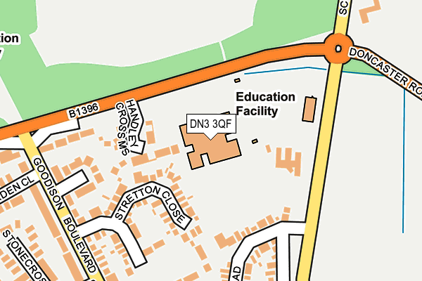
DN3 3QF lies on Cantley Lane in Cantley, Doncaster. DN3 3QF is located in the Finningley electoral ward, within the metropolitan district of Doncaster and the English Parliamentary constituency of Don Valley. The Sub Integrated Care Board (ICB) Location is NHS South Yorkshire ICB - 02X and the police force is South Yorkshire. This postcode has been in use since January 1995.


GetTheData
Source: OS OpenMap – Local (Ordnance Survey)
Source: OS VectorMap District (Ordnance Survey)
Licence: Open Government Licence (requires attribution)
| Easting | 462447 |
| Northing | 401681 |
| Latitude | 53.508117 |
| Longitude | -1.059881 |
GetTheData
Source: Open Postcode Geo
Licence: Open Government Licence
| Street | Cantley Lane |
| Locality | Cantley |
| Town/City | Doncaster |
| Country | England |
| Postcode District | DN3 |
➜ See where DN3 is on a map ➜ Where is Doncaster? | |
GetTheData
Source: Land Registry Price Paid Data
Licence: Open Government Licence
Elevation or altitude of DN3 3QF as distance above sea level:
| Metres | Feet | |
|---|---|---|
| Elevation | 10m | 33ft |
Elevation is measured from the approximate centre of the postcode, to the nearest point on an OS contour line from OS Terrain 50, which has contour spacing of ten vertical metres.
➜ How high above sea level am I? Find the elevation of your current position using your device's GPS.
GetTheData
Source: Open Postcode Elevation
Licence: Open Government Licence
| Ward | Finningley |
| Constituency | Don Valley |
GetTheData
Source: ONS Postcode Database
Licence: Open Government Licence
HANDLEY CROSS, CANTLEY LANE, CANTLEY, DONCASTER, DN3 3QF 2014 16 MAY £755,000 |
GetTheData
Source: HM Land Registry Price Paid Data
Licence: Contains HM Land Registry data © Crown copyright and database right 2025. This data is licensed under the Open Government Licence v3.0.
| Mcauley Upper School Bus Park | Cantley | 74m |
| The Mcauley School (Cantley Lane) | Cantley | 86m |
| School Lane (Cantley Lane) | Cantley | 176m |
| Warning Tongue Lane (Doncaster Road) | Cantley | 267m |
| Staunton Road (Goodison Boulevard) | Cantley | 318m |
GetTheData
Source: NaPTAN
Licence: Open Government Licence
GetTheData
Source: ONS Postcode Database
Licence: Open Government Licence


➜ Get more ratings from the Food Standards Agency
GetTheData
Source: Food Standards Agency
Licence: FSA terms & conditions
| Last Collection | |||
|---|---|---|---|
| Location | Mon-Fri | Sat | Distance |
| Staunton Road | 17:45 | 11:30 | 299m |
| Cantley Manor Avenue | 17:45 | 11:30 | 618m |
| Green Lane | 16:15 | 09:00 | 651m |
GetTheData
Source: Dracos
Licence: Creative Commons Attribution-ShareAlike
The below table lists the International Territorial Level (ITL) codes (formerly Nomenclature of Territorial Units for Statistics (NUTS) codes) and Local Administrative Units (LAU) codes for DN3 3QF:
| ITL 1 Code | Name |
|---|---|
| TLE | Yorkshire and The Humber |
| ITL 2 Code | Name |
| TLE3 | South Yorkshire |
| ITL 3 Code | Name |
| TLE31 | Barnsley, Doncaster and Rotherham |
| LAU 1 Code | Name |
| E08000017 | Doncaster |
GetTheData
Source: ONS Postcode Directory
Licence: Open Government Licence
The below table lists the Census Output Area (OA), Lower Layer Super Output Area (LSOA), and Middle Layer Super Output Area (MSOA) for DN3 3QF:
| Code | Name | |
|---|---|---|
| OA | E00038514 | |
| LSOA | E01007603 | Doncaster 026E |
| MSOA | E02001564 | Doncaster 026 |
GetTheData
Source: ONS Postcode Directory
Licence: Open Government Licence
| DN3 3QZ | Handley Cross Mews | 76m |
| DN4 6UE | Stretton Close | 161m |
| DN4 6UF | Staunton Road | 194m |
| DN4 6UD | Goodison Boulevard | 223m |
| DN4 6UG | Staunton Road | 248m |
| DN4 6TT | Warning Tongue Lane | 271m |
| DN4 6QT | Cantley Lane | 280m |
| DN4 6QF | Stonecross Gardens | 290m |
| DN4 6RW | Goodison Boulevard | 294m |
| DN4 6TF | Greenfield Gardens | 323m |
GetTheData
Source: Open Postcode Geo; Land Registry Price Paid Data
Licence: Open Government Licence