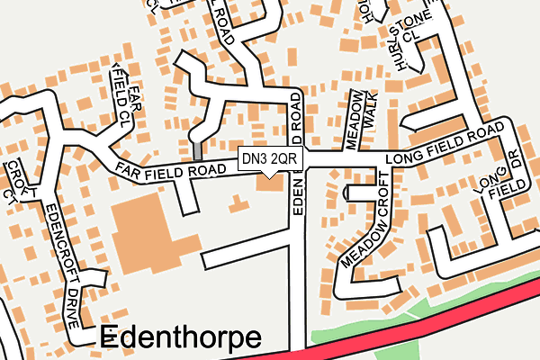
DN3 2QR is located in the Edenthorpe & Kirk Sandall electoral ward, within the metropolitan district of Doncaster and the English Parliamentary constituency of Doncaster Central. The Sub Integrated Care Board (ICB) Location is NHS South Yorkshire ICB - 02X and the police force is South Yorkshire. This postcode has been in use since January 1991.


GetTheData
Source: OS OpenMap – Local (Ordnance Survey)
Source: OS VectorMap District (Ordnance Survey)
Licence: Open Government Licence (requires attribution)
| Easting | 462196 |
| Northing | 406957 |
| Latitude | 53.555583 |
| Longitude | -1.062624 |
GetTheData
Source: Open Postcode Geo
Licence: Open Government Licence
| Country | England |
| Postcode District | DN3 |
➜ See where DN3 is on a map ➜ Where is Edenthorpe? | |
GetTheData
Source: Land Registry Price Paid Data
Licence: Open Government Licence
Elevation or altitude of DN3 2QR as distance above sea level:
| Metres | Feet | |
|---|---|---|
| Elevation | 10m | 33ft |
Elevation is measured from the approximate centre of the postcode, to the nearest point on an OS contour line from OS Terrain 50, which has contour spacing of ten vertical metres.
➜ How high above sea level am I? Find the elevation of your current position using your device's GPS.
GetTheData
Source: Open Postcode Elevation
Licence: Open Government Licence
| Ward | Edenthorpe & Kirk Sandall |
| Constituency | Doncaster Central |
GetTheData
Source: ONS Postcode Database
Licence: Open Government Licence
| Thorne Road (Edenfield Road) | Edenthorpe | 111m |
| Eden Field Road (Thorne Road) | Edenthorpe | 133m |
| Longfield Road (Edenfield Road) | Edenthorpe | 141m |
| Eden Field Road (Thorne Road) | Edenthorpe | 155m |
| Athelstane Crescent (Church Balk) | Edenthorpe | 329m |
| Kirk Sandall Station | 1.2km |
| Hatfield & Stainforth Station | 4.5km |
GetTheData
Source: NaPTAN
Licence: Open Government Licence
GetTheData
Source: ONS Postcode Database
Licence: Open Government Licence


➜ Get more ratings from the Food Standards Agency
GetTheData
Source: Food Standards Agency
Licence: FSA terms & conditions
| Last Collection | |||
|---|---|---|---|
| Location | Mon-Fri | Sat | Distance |
| Thorne Road | 17:00 | 12:00 | 178m |
| New Hall Road | 17:15 | 10:30 | 506m |
| Church Balk | 16:00 | 09:00 | 587m |
GetTheData
Source: Dracos
Licence: Creative Commons Attribution-ShareAlike
The below table lists the International Territorial Level (ITL) codes (formerly Nomenclature of Territorial Units for Statistics (NUTS) codes) and Local Administrative Units (LAU) codes for DN3 2QR:
| ITL 1 Code | Name |
|---|---|
| TLE | Yorkshire and The Humber |
| ITL 2 Code | Name |
| TLE3 | South Yorkshire |
| ITL 3 Code | Name |
| TLE31 | Barnsley, Doncaster and Rotherham |
| LAU 1 Code | Name |
| E08000017 | Doncaster |
GetTheData
Source: ONS Postcode Directory
Licence: Open Government Licence
The below table lists the Census Output Area (OA), Lower Layer Super Output Area (LSOA), and Middle Layer Super Output Area (MSOA) for DN3 2QR:
| Code | Name | |
|---|---|---|
| OA | E00037932 | |
| LSOA | E01007475 | Doncaster 011A |
| MSOA | E02001549 | Doncaster 011 |
GetTheData
Source: ONS Postcode Directory
Licence: Open Government Licence
| DN3 2RL | Worral Court | 97m |
| DN3 2RP | Fen Court | 105m |
| DN3 2NS | Far Field Road | 113m |
| DN3 2NX | Harvest Close | 116m |
| DN3 2RN | Holme Wood Court | 121m |
| DN3 2RB | Edencroft Drive | 159m |
| DN3 2RJ | Cosgrove Court | 173m |
| DN3 2RD | Edencroft Drive | 183m |
| DN3 2NZ | Thorpehall Road | 188m |
| DN3 2RA | Far Field Close | 189m |
GetTheData
Source: Open Postcode Geo; Land Registry Price Paid Data
Licence: Open Government Licence