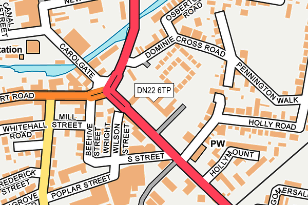
DN22 6TP is located in the East Retford East electoral ward, within the local authority district of Bassetlaw and the English Parliamentary constituency of Bassetlaw. The Sub Integrated Care Board (ICB) Location is NHS Nottingham and Nottinghamshire ICB - 02Q and the police force is Nottinghamshire. This postcode has been in use since April 2017.


GetTheData
Source: OS OpenMap – Local (Ordnance Survey)
Source: OS VectorMap District (Ordnance Survey)
Licence: Open Government Licence (requires attribution)
| Easting | 470841 |
| Northing | 380674 |
| Latitude | 53.318286 |
| Longitude | -0.938049 |
GetTheData
Source: Open Postcode Geo
Licence: Open Government Licence
| Country | England |
| Postcode District | DN22 |
➜ See where DN22 is on a map ➜ Where is Retford? | |
GetTheData
Source: Land Registry Price Paid Data
Licence: Open Government Licence
| Ward | East Retford East |
| Constituency | Bassetlaw |
GetTheData
Source: ONS Postcode Database
Licence: Open Government Licence
| South Street (London Road) | Retford | 63m |
| South Street (London Road) | Retford | 70m |
| Thrumpton Lane (Albert Road) | Retford | 197m |
| Thrumpton Lane (Albert Road) | Retford | 198m |
| Avenue Road (London Road) | Retford | 327m |
| Retford Low Level Station | 0.6km |
| Retford Station | 0.7km |
GetTheData
Source: NaPTAN
Licence: Open Government Licence
| Median download speed | 40.0Mbps |
| Average download speed | 41.2Mbps |
| Maximum download speed | 79.98Mbps |
| Median upload speed | 10.0Mbps |
| Average upload speed | 10.2Mbps |
| Maximum upload speed | 20.00Mbps |
GetTheData
Source: Ofcom
Licence: Ofcom Terms of Use (requires attribution)
GetTheData
Source: ONS Postcode Database
Licence: Open Government Licence


➜ Get more ratings from the Food Standards Agency
GetTheData
Source: Food Standards Agency
Licence: FSA terms & conditions
| Last Collection | |||
|---|---|---|---|
| Location | Mon-Fri | Sat | Distance |
| London Road Post Office | 17:30 | 11:45 | 89m |
| Holly Road | 16:30 | 11:30 | 250m |
| Carolgate Post Office | 18:15 | 12:15 | 338m |
GetTheData
Source: Dracos
Licence: Creative Commons Attribution-ShareAlike
The below table lists the International Territorial Level (ITL) codes (formerly Nomenclature of Territorial Units for Statistics (NUTS) codes) and Local Administrative Units (LAU) codes for DN22 6TP:
| ITL 1 Code | Name |
|---|---|
| TLF | East Midlands (England) |
| ITL 2 Code | Name |
| TLF1 | Derbyshire and Nottinghamshire |
| ITL 3 Code | Name |
| TLF15 | North Nottinghamshire |
| LAU 1 Code | Name |
| E07000171 | Bassetlaw |
GetTheData
Source: ONS Postcode Directory
Licence: Open Government Licence
The below table lists the Census Output Area (OA), Lower Layer Super Output Area (LSOA), and Middle Layer Super Output Area (MSOA) for DN22 6TP:
| Code | Name | |
|---|---|---|
| OA | E00142710 | |
| LSOA | E01028012 | Bassetlaw 008E |
| MSOA | E02005842 | Bassetlaw 008 |
GetTheData
Source: ONS Postcode Directory
Licence: Open Government Licence
| DN22 6NZ | Sherwood Square | 61m |
| DN22 6AT | London Road | 72m |
| DN22 6AY | London Road | 73m |
| DN22 6BG | Holly Court | 103m |
| DN22 6NT | Tudor Villas | 114m |
| DN22 6BA | Wright Wilson Street | 118m |
| DN22 6LU | Albion Terrace | 120m |
| DN22 6NL | Dominie Cross Road | 124m |
| DN22 6JF | Albert Road | 137m |
| DN22 6LX | King Edward Terrace | 140m |
GetTheData
Source: Open Postcode Geo; Land Registry Price Paid Data
Licence: Open Government Licence