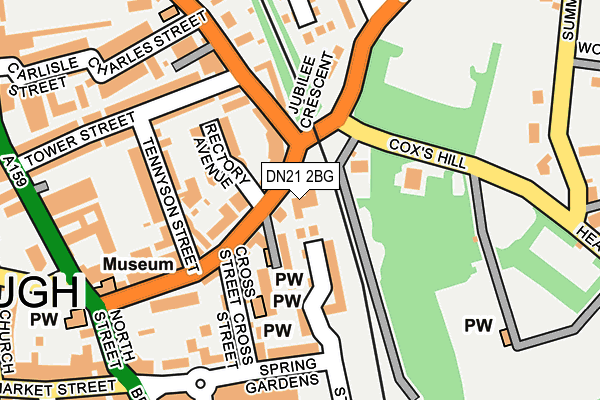
DN21 2BG is located in the Gainsborough South-West electoral ward, within the local authority district of West Lindsey and the English Parliamentary constituency of Gainsborough. The Sub Integrated Care Board (ICB) Location is NHS Lincolnshire ICB - 71E and the police force is Lincolnshire. This postcode has been in use since August 2011.


GetTheData
Source: OS OpenMap – Local (Ordnance Survey)
Source: OS VectorMap District (Ordnance Survey)
Licence: Open Government Licence (requires attribution)
| Easting | 481815 |
| Northing | 390108 |
| Latitude | 53.401465 |
| Longitude | -0.770918 |
GetTheData
Source: Open Postcode Geo
Licence: Open Government Licence
| Country | England |
| Postcode District | DN21 |
➜ See where DN21 is on a map ➜ Where is Gainsborough? | |
GetTheData
Source: Land Registry Price Paid Data
Licence: Open Government Licence
Elevation or altitude of DN21 2BG as distance above sea level:
| Metres | Feet | |
|---|---|---|
| Elevation | 10m | 33ft |
Elevation is measured from the approximate centre of the postcode, to the nearest point on an OS contour line from OS Terrain 50, which has contour spacing of ten vertical metres.
➜ How high above sea level am I? Find the elevation of your current position using your device's GPS.
GetTheData
Source: Open Postcode Elevation
Licence: Open Government Licence
| Ward | Gainsborough South-west |
| Constituency | Gainsborough |
GetTheData
Source: ONS Postcode Database
Licence: Open Government Licence
| Surgery (Spital Terrace) | Gainsborough | 153m |
| Surgery (Spital Terrace) | Gainsborough | 170m |
| Hawthorn Avenue (Spital Hill) | Gainsborough | 226m |
| Hawthorn Avenue (Spital Hill) | Gainsborough | 254m |
| Highfield Lodge (Summer Hill) | Gainsborough | 337m |
| Gainsborough Central Station | 0.2km |
| Gainsborough Lea Road Station | 1.7km |
GetTheData
Source: NaPTAN
Licence: Open Government Licence
| Median download speed | 21.7Mbps |
| Average download speed | 32.1Mbps |
| Maximum download speed | 80.00Mbps |
| Median upload speed | 1.3Mbps |
| Average upload speed | 4.9Mbps |
| Maximum upload speed | 20.00Mbps |
GetTheData
Source: Ofcom
Licence: Ofcom Terms of Use (requires attribution)
Estimated total energy consumption in DN21 2BG by fuel type, 2015.
| Consumption (kWh) | 45,999 |
|---|---|
| Meter count | 8 |
| Mean (kWh/meter) | 5,750 |
| Median (kWh/meter) | 4,814 |
GetTheData
Source: Postcode level gas estimates: 2015 (experimental)
Source: Postcode level electricity estimates: 2015 (experimental)
Licence: Open Government Licence
GetTheData
Source: ONS Postcode Database
Licence: Open Government Licence


➜ Get more ratings from the Food Standards Agency
GetTheData
Source: Food Standards Agency
Licence: FSA terms & conditions
| Last Collection | |||
|---|---|---|---|
| Location | Mon-Fri | Sat | Distance |
| Church Street | 17:00 | 12:00 | 357m |
| Market Place | 17:00 | 11:45 | 386m |
| Gainsborough Delivery Office | 17:30 | 12:30 | 457m |
GetTheData
Source: Dracos
Licence: Creative Commons Attribution-ShareAlike
The below table lists the International Territorial Level (ITL) codes (formerly Nomenclature of Territorial Units for Statistics (NUTS) codes) and Local Administrative Units (LAU) codes for DN21 2BG:
| ITL 1 Code | Name |
|---|---|
| TLF | East Midlands (England) |
| ITL 2 Code | Name |
| TLF3 | Lincolnshire |
| ITL 3 Code | Name |
| TLF30 | Lincolnshire CC |
| LAU 1 Code | Name |
| E07000142 | West Lindsey |
GetTheData
Source: ONS Postcode Directory
Licence: Open Government Licence
The below table lists the Census Output Area (OA), Lower Layer Super Output Area (LSOA), and Middle Layer Super Output Area (MSOA) for DN21 2BG:
| Code | Name | |
|---|---|---|
| OA | E00134028 | |
| LSOA | E01026384 | West Lindsey 004F |
| MSOA | E02005495 | West Lindsey 004 |
GetTheData
Source: ONS Postcode Directory
Licence: Open Government Licence
| DN21 2HQ | Spital Terrace | 55m |
| DN21 2HJ | Jubilee Crescent | 60m |
| DN21 2HH | Malpas Avenue | 70m |
| DN21 2HL | Marshall's Rise | 81m |
| DN21 2JE | Rectory Avenue | 106m |
| DN21 2FB | James Court | 114m |
| DN21 1HH | Coxs Hill | 115m |
| DN21 2AX | St Thomas Mews | 131m |
| DN21 1EE | Spital Hill | 142m |
| DN21 2HD | Spital Terrace | 144m |
GetTheData
Source: Open Postcode Geo; Land Registry Price Paid Data
Licence: Open Government Licence