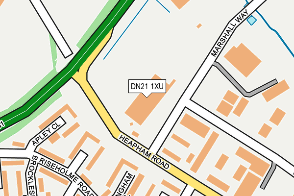
DN21 1XU is located in the Gainsborough East electoral ward, within the local authority district of West Lindsey and the English Parliamentary constituency of Gainsborough. The Sub Integrated Care Board (ICB) Location is NHS Lincolnshire ICB - 71E and the police force is Lincolnshire. This postcode has been in use since January 1980.


GetTheData
Source: OS OpenMap – Local (Ordnance Survey)
Source: OS VectorMap District (Ordnance Survey)
Licence: Open Government Licence (requires attribution)
| Easting | 483098 |
| Northing | 389341 |
| Latitude | 53.394372 |
| Longitude | -0.751828 |
GetTheData
Source: Open Postcode Geo
Licence: Open Government Licence
| Country | England |
| Postcode District | DN21 |
➜ See where DN21 is on a map ➜ Where is Gainsborough? | |
GetTheData
Source: Land Registry Price Paid Data
Licence: Open Government Licence
Elevation or altitude of DN21 1XU as distance above sea level:
| Metres | Feet | |
|---|---|---|
| Elevation | 30m | 98ft |
Elevation is measured from the approximate centre of the postcode, to the nearest point on an OS contour line from OS Terrain 50, which has contour spacing of ten vertical metres.
➜ How high above sea level am I? Find the elevation of your current position using your device's GPS.
GetTheData
Source: Open Postcode Elevation
Licence: Open Government Licence
| Ward | Gainsborough East |
| Constituency | Gainsborough |
GetTheData
Source: ONS Postcode Database
Licence: Open Government Licence
| Marshall Way (Heapham Road) | Gainsborough | 129m |
| Marshall Way (Heapham Road) | Gainsborough | 129m |
| Fillingham Close (Riseholme Road) | Gainsborough | 226m |
| Keelby Road (Glentham Road) | Gainsborough | 256m |
| Fillingham Close (Riseholme Road) | Gainsborough | 268m |
| Gainsborough Central Station | 1.3km |
| Gainsborough Lea Road Station | 1.4km |
GetTheData
Source: NaPTAN
Licence: Open Government Licence
GetTheData
Source: ONS Postcode Database
Licence: Open Government Licence


➜ Get more ratings from the Food Standards Agency
GetTheData
Source: Food Standards Agency
Licence: FSA terms & conditions
| Last Collection | |||
|---|---|---|---|
| Location | Mon-Fri | Sat | Distance |
| Glentham Road | 17:00 | 11:45 | 287m |
| Scampton Way | 17:00 | 11:45 | 580m |
| The Drive | 17:00 | 11:45 | 633m |
GetTheData
Source: Dracos
Licence: Creative Commons Attribution-ShareAlike
The below table lists the International Territorial Level (ITL) codes (formerly Nomenclature of Territorial Units for Statistics (NUTS) codes) and Local Administrative Units (LAU) codes for DN21 1XU:
| ITL 1 Code | Name |
|---|---|
| TLF | East Midlands (England) |
| ITL 2 Code | Name |
| TLF3 | Lincolnshire |
| ITL 3 Code | Name |
| TLF30 | Lincolnshire CC |
| LAU 1 Code | Name |
| E07000142 | West Lindsey |
GetTheData
Source: ONS Postcode Directory
Licence: Open Government Licence
The below table lists the Census Output Area (OA), Lower Layer Super Output Area (LSOA), and Middle Layer Super Output Area (MSOA) for DN21 1XU:
| Code | Name | |
|---|---|---|
| OA | E00133986 | |
| LSOA | E01026375 | West Lindsey 006B |
| MSOA | E02005497 | West Lindsey 006 |
GetTheData
Source: ONS Postcode Directory
Licence: Open Government Licence
| DN21 1PT | Heapham Road South | 78m |
| DN21 1YX | Fillingham Close | 166m |
| DN21 1YY | Grasby Close | 187m |
| DN21 1SQ | Apley Close | 190m |
| DN21 1SG | Riseholme Road | 224m |
| DN21 1YT | Riseholme Road | 239m |
| DN21 1YU | Riseholme Road | 250m |
| DN21 1YZ | Glentham Road | 251m |
| DN21 1SA | Glentham Road | 259m |
| DN21 1TS | Linwood Close | 272m |
GetTheData
Source: Open Postcode Geo; Land Registry Price Paid Data
Licence: Open Government Licence