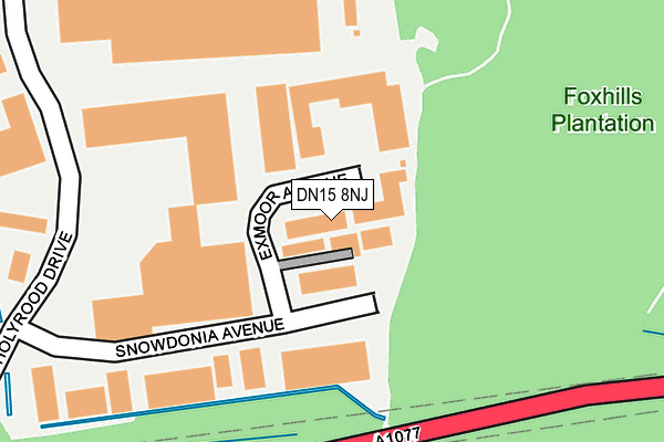
DN15 8NJ lies on Exmoor Avenue in Scunthorpe. DN15 8NJ is located in the Crosby & Park electoral ward, within the unitary authority of North Lincolnshire and the English Parliamentary constituency of Scunthorpe. The Sub Integrated Care Board (ICB) Location is NHS Humber and North Yorkshire ICB - 03K and the police force is Humberside. This postcode has been in use since October 1985.


GetTheData
Source: OS OpenMap – Local (Ordnance Survey)
Source: OS VectorMap District (Ordnance Survey)
Licence: Open Government Licence (requires attribution)
| Easting | 487804 |
| Northing | 413192 |
| Latitude | 53.607959 |
| Longitude | -0.674414 |
GetTheData
Source: Open Postcode Geo
Licence: Open Government Licence
| Street | Exmoor Avenue |
| Town/City | Scunthorpe |
| Country | England |
| Postcode District | DN15 |
➜ See where DN15 is on a map ➜ Where is Scunthorpe? | |
GetTheData
Source: Land Registry Price Paid Data
Licence: Open Government Licence
Elevation or altitude of DN15 8NJ as distance above sea level:
| Metres | Feet | |
|---|---|---|
| Elevation | 10m | 33ft |
Elevation is measured from the approximate centre of the postcode, to the nearest point on an OS contour line from OS Terrain 50, which has contour spacing of ten vertical metres.
➜ How high above sea level am I? Find the elevation of your current position using your device's GPS.
GetTheData
Source: Open Postcode Elevation
Licence: Open Government Licence
| Ward | Crosby & Park |
| Constituency | Scunthorpe |
GetTheData
Source: ONS Postcode Database
Licence: Open Government Licence
| Skippingdale Retail Park (Holyrood Drive) | Scunthorpe | 233m |
| Sorrell Way (Luneburg Way) | Scunthorpe | 536m |
| Sorrell Way (Luneburg Way) | Scunthorpe | 639m |
| Two Sisters (Ram Boulevard) | Foxhills Industrial Park | 691m |
| St Marys Court (Speedwell Crescent) | Scunthorpe | 691m |
| Scunthorpe Station | 2.9km |
| Althorpe Station | 4.6km |
GetTheData
Source: NaPTAN
Licence: Open Government Licence
Estimated total energy consumption in DN15 8NJ by fuel type, 2015.
| Consumption (kWh) | 143,883 |
|---|---|
| Meter count | 11 |
| Mean (kWh/meter) | 13,080 |
| Median (kWh/meter) | 2,233 |
GetTheData
Source: Postcode level gas estimates: 2015 (experimental)
Source: Postcode level electricity estimates: 2015 (experimental)
Licence: Open Government Licence
GetTheData
Source: ONS Postcode Database
Licence: Open Government Licence


➜ Get more ratings from the Food Standards Agency
GetTheData
Source: Food Standards Agency
Licence: FSA terms & conditions
| Last Collection | |||
|---|---|---|---|
| Location | Mon-Fri | Sat | Distance |
| Sorrell Way | 17:15 | 12:00 | 530m |
| Avenue Cannes | 17:30 | 12:00 | 622m |
| Atkinson Way | 18:30 | 09:30 | 884m |
GetTheData
Source: Dracos
Licence: Creative Commons Attribution-ShareAlike
The below table lists the International Territorial Level (ITL) codes (formerly Nomenclature of Territorial Units for Statistics (NUTS) codes) and Local Administrative Units (LAU) codes for DN15 8NJ:
| ITL 1 Code | Name |
|---|---|
| TLE | Yorkshire and The Humber |
| ITL 2 Code | Name |
| TLE1 | East Yorkshire and Northern Lincolnshire |
| ITL 3 Code | Name |
| TLE13 | North and North East Lincolnshire |
| LAU 1 Code | Name |
| E06000013 | North Lincolnshire |
GetTheData
Source: ONS Postcode Directory
Licence: Open Government Licence
The below table lists the Census Output Area (OA), Lower Layer Super Output Area (LSOA), and Middle Layer Super Output Area (MSOA) for DN15 8NJ:
| Code | Name | |
|---|---|---|
| OA | E00067111 | |
| LSOA | E01013297 | North Lincolnshire 007A |
| MSOA | E02002755 | North Lincolnshire 007 |
GetTheData
Source: ONS Postcode Directory
Licence: Open Government Licence
| DN15 8NL | Snowdonia Avenue | 162m |
| DN15 8NN | Holyrood Drive | 206m |
| DN15 8PP | Betony Close | 515m |
| DN15 8JB | Goldcrest Close | 578m |
| DN15 8PN | Coltsfoot Close | 581m |
| DN15 8JD | Linnet Close | 593m |
| DN15 8XQ | Primrose Way | 605m |
| DN15 8XJ | Fletcher Close | 627m |
| DN15 8PL | Sorrel Way | 642m |
| DN15 8TB | Avenswood Lane | 680m |
GetTheData
Source: Open Postcode Geo; Land Registry Price Paid Data
Licence: Open Government Licence