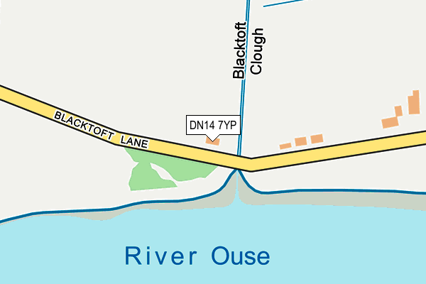
DN14 7YP is located in the Howdenshire electoral ward, within the unitary authority of East Riding of Yorkshire and the English Parliamentary constituency of Haltemprice and Howden. The Sub Integrated Care Board (ICB) Location is NHS Humber and North Yorkshire ICB - 02Y and the police force is Humberside. This postcode has been in use since January 1980.


GetTheData
Source: OS OpenMap – Local (Ordnance Survey)
Source: OS VectorMap District (Ordnance Survey)
Licence: Open Government Licence (requires attribution)
| Easting | 483723 |
| Northing | 424261 |
| Latitude | 53.708070 |
| Longitude | -0.733094 |
GetTheData
Source: Open Postcode Geo
Licence: Open Government Licence
| Country | England |
| Postcode District | DN14 |
➜ See where DN14 is on a map | |
GetTheData
Source: Land Registry Price Paid Data
Licence: Open Government Licence
Elevation or altitude of DN14 7YP as distance above sea level:
| Metres | Feet | |
|---|---|---|
| Elevation | 0m | 0ft |
Elevation is measured from the approximate centre of the postcode, to the nearest point on an OS contour line from OS Terrain 50, which has contour spacing of ten vertical metres.
➜ How high above sea level am I? Find the elevation of your current position using your device's GPS.
GetTheData
Source: Open Postcode Elevation
Licence: Open Government Licence
| Ward | Howdenshire |
| Constituency | Haltemprice And Howden |
GetTheData
Source: ONS Postcode Database
Licence: Open Government Licence
| Blacktoft Clough (Blacktoft Lane) | Blacktoft | 384m |
| Blacktoft Sands (Blacktoft Lane) | Blacktoft | 507m |
| Blacktoft Sands (Townend Causeway) | Ousefleet | 1,364m |
| Blacktoft Sands (Townend Causeway) | Ousefleet | 1,368m |
| Ousefleet Townend Causeway (Townend Causeway) | Ousefleet | 1,445m |
| Gilberdyke Station | 4.4km |
| Broomfleet Station | 5.4km |
GetTheData
Source: NaPTAN
Licence: Open Government Licence
GetTheData
Source: ONS Postcode Database
Licence: Open Government Licence
| Last Collection | |||
|---|---|---|---|
| Location | Mon-Fri | Sat | Distance |
| Blacktoft | 16:15 | 09:30 | 502m |
| Main Street | 16:15 | 08:45 | 1,292m |
| Yokefleet | 16:15 | 08:00 | 1,782m |
GetTheData
Source: Dracos
Licence: Creative Commons Attribution-ShareAlike
| Risk of DN14 7YP flooding from rivers and sea | Medium |
| ➜ DN14 7YP flood map | |
GetTheData
Source: Open Flood Risk by Postcode
Licence: Open Government Licence
The below table lists the International Territorial Level (ITL) codes (formerly Nomenclature of Territorial Units for Statistics (NUTS) codes) and Local Administrative Units (LAU) codes for DN14 7YP:
| ITL 1 Code | Name |
|---|---|
| TLE | Yorkshire and The Humber |
| ITL 2 Code | Name |
| TLE1 | East Yorkshire and Northern Lincolnshire |
| ITL 3 Code | Name |
| TLE12 | East Riding of Yorkshire |
| LAU 1 Code | Name |
| E06000011 | East Riding of Yorkshire |
GetTheData
Source: ONS Postcode Directory
Licence: Open Government Licence
The below table lists the Census Output Area (OA), Lower Layer Super Output Area (LSOA), and Middle Layer Super Output Area (MSOA) for DN14 7YP:
| Code | Name | |
|---|---|---|
| OA | E00065675 | |
| LSOA | E01013021 | East Riding of Yorkshire 026C |
| MSOA | E02002709 | East Riding of Yorkshire 026 |
GetTheData
Source: ONS Postcode Directory
Licence: Open Government Licence
| DN14 7YW | Main Street | 621m |
| DN14 7YN | Sparrowcroft Lane | 957m |
| DN14 8HR | 1224m | |
| DN14 7XT | Staddlethorpe Lane | 1413m |
| DN14 8HP | Hill Crest | 1435m |
| DN14 8HW | 1548m | |
| DN14 7XY | 1691m | |
| DN14 8HN | Eastons Cottages | 2102m |
| DN14 8HL | 2240m | |
| DN14 7YS | Faxfleet Lane | 2489m |
GetTheData
Source: Open Postcode Geo; Land Registry Price Paid Data
Licence: Open Government Licence