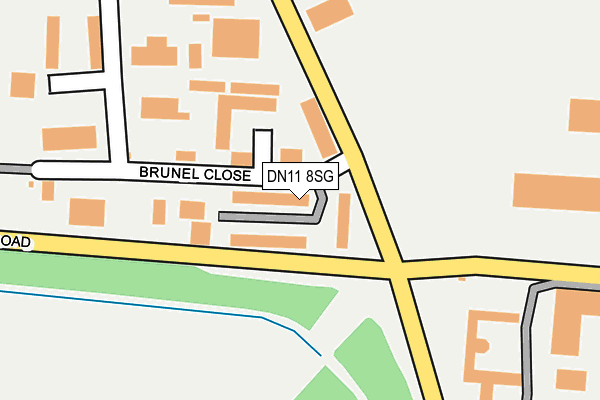
DN11 8SG lies on British Coal Enterprise Park in Harworth, Doncaster. DN11 8SG is located in the Blyth electoral ward, within the local authority district of Bassetlaw and the English Parliamentary constituency of Bassetlaw. The Sub Integrated Care Board (ICB) Location is NHS Nottingham and Nottinghamshire ICB - 02Q and the police force is Nottinghamshire. This postcode has been in use since December 1994.


GetTheData
Source: OS OpenMap – Local (Ordnance Survey)
Source: OS VectorMap District (Ordnance Survey)
Licence: Open Government Licence (requires attribution)
| Easting | 461865 |
| Northing | 390653 |
| Latitude | 53.409093 |
| Longitude | -1.070822 |
GetTheData
Source: Open Postcode Geo
Licence: Open Government Licence
| Street | British Coal Enterprise Park |
| Locality | Harworth |
| Town/City | Doncaster |
| Country | England |
| Postcode District | DN11 |
➜ See where DN11 is on a map | |
GetTheData
Source: Land Registry Price Paid Data
Licence: Open Government Licence
Elevation or altitude of DN11 8SG as distance above sea level:
| Metres | Feet | |
|---|---|---|
| Elevation | 30m | 98ft |
Elevation is measured from the approximate centre of the postcode, to the nearest point on an OS contour line from OS Terrain 50, which has contour spacing of ten vertical metres.
➜ How high above sea level am I? Find the elevation of your current position using your device's GPS.
GetTheData
Source: Open Postcode Elevation
Licence: Open Government Licence
| Ward | Blyth |
| Constituency | Bassetlaw |
GetTheData
Source: ONS Postcode Database
Licence: Open Government Licence
| Industrial Estate (Blyth Road) | Harworth | 110m |
| Industrial Estate (Blyth Road) | Harworth | 120m |
| Certex (Serlby Road) | Harworth | 266m |
| Industrial Estate (Brunel Close) | Harworth | 293m |
| Certex (Serlby Road) | Harworth | 313m |
GetTheData
Source: NaPTAN
Licence: Open Government Licence
| Median download speed | 3.5Mbps |
| Average download speed | 25.1Mbps |
| Maximum download speed | 80.00Mbps |
| Median upload speed | 0.9Mbps |
| Average upload speed | 6.5Mbps |
| Maximum upload speed | 20.00Mbps |
GetTheData
Source: Ofcom
Licence: Ofcom Terms of Use (requires attribution)
GetTheData
Source: ONS Postcode Database
Licence: Open Government Licence


➜ Get more ratings from the Food Standards Agency
GetTheData
Source: Food Standards Agency
Licence: FSA terms & conditions
| Last Collection | |||
|---|---|---|---|
| Location | Mon-Fri | Sat | Distance |
| Brunel Ie | 16:45 | 11:15 | 76m |
| Harworth Post Office | 17:00 | 11:00 | 955m |
| Scrooby Road | 17:00 | 10:45 | 983m |
GetTheData
Source: Dracos
Licence: Creative Commons Attribution-ShareAlike
The below table lists the International Territorial Level (ITL) codes (formerly Nomenclature of Territorial Units for Statistics (NUTS) codes) and Local Administrative Units (LAU) codes for DN11 8SG:
| ITL 1 Code | Name |
|---|---|
| TLF | East Midlands (England) |
| ITL 2 Code | Name |
| TLF1 | Derbyshire and Nottinghamshire |
| ITL 3 Code | Name |
| TLF15 | North Nottinghamshire |
| LAU 1 Code | Name |
| E07000171 | Bassetlaw |
GetTheData
Source: ONS Postcode Directory
Licence: Open Government Licence
The below table lists the Census Output Area (OA), Lower Layer Super Output Area (LSOA), and Middle Layer Super Output Area (MSOA) for DN11 8SG:
| Code | Name | |
|---|---|---|
| OA | E00142665 | |
| LSOA | E01028000 | Bassetlaw 001A |
| MSOA | E02005835 | Bassetlaw 001 |
GetTheData
Source: ONS Postcode Directory
Licence: Open Government Licence
| DN11 8QB | Brunel Gate | 134m |
| DN11 8NE | Blyth Road | 221m |
| DN11 8BZ | Lords Wood Road | 233m |
| DN11 8QA | Brunel Close | 238m |
| DN11 8RX | Hesley Road | 795m |
| DN11 8JZ | Main Street | 842m |
| DN11 8LT | Serlby Road | 846m |
| DN11 8JT | Scrooby Road | 847m |
| DN11 8LU | Pagdin Drive | 859m |
| DN11 8NY | Melbourne Grove | 872m |
GetTheData
Source: Open Postcode Geo; Land Registry Price Paid Data
Licence: Open Government Licence