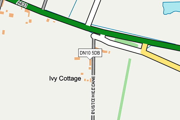
DN10 5DB is located in the Everton electoral ward, within the local authority district of Bassetlaw and the English Parliamentary constituency of Bassetlaw. The Sub Integrated Care Board (ICB) Location is NHS Nottingham and Nottinghamshire ICB - 02Q and the police force is Nottinghamshire. This postcode has been in use since February 2017.


GetTheData
Source: OS OpenMap – Local (Ordnance Survey)
Source: OS VectorMap District (Ordnance Survey)
Licence: Open Government Licence (requires attribution)
| Easting | 469688 |
| Northing | 390690 |
| Latitude | 53.408454 |
| Longitude | -0.953152 |
GetTheData
Source: Open Postcode Geo
Licence: Open Government Licence
| Country | England |
| Postcode District | DN10 |
➜ See where DN10 is on a map | |
GetTheData
Source: Land Registry Price Paid Data
Licence: Open Government Licence
| Ward | Everton |
| Constituency | Bassetlaw |
GetTheData
Source: ONS Postcode Database
Licence: Open Government Licence
| Sun Inn (Gainsborough Road) | Everton | 602m |
| Sun Inn (Gainsborough Road) | Everton | 605m |
| Sun Inn (Mattersey Road) | Everton | 623m |
| Sun Inn (Mattersey Road) | Everton | 632m |
| Demand Responsive Area (Phoneabus) | Everton | 635m |
GetTheData
Source: NaPTAN
Licence: Open Government Licence
GetTheData
Source: ONS Postcode Database
Licence: Open Government Licence


➜ Get more ratings from the Food Standards Agency
GetTheData
Source: Food Standards Agency
Licence: FSA terms & conditions
| Last Collection | |||
|---|---|---|---|
| Location | Mon-Fri | Sat | Distance |
| Everton Post Office | 17:30 | 11:00 | 614m |
| Everton Church | 17:30 | 10:45 | 791m |
| Old Gainsborough Road | 17:00 | 11:00 | 923m |
GetTheData
Source: Dracos
Licence: Creative Commons Attribution-ShareAlike
The below table lists the International Territorial Level (ITL) codes (formerly Nomenclature of Territorial Units for Statistics (NUTS) codes) and Local Administrative Units (LAU) codes for DN10 5DB:
| ITL 1 Code | Name |
|---|---|
| TLF | East Midlands (England) |
| ITL 2 Code | Name |
| TLF1 | Derbyshire and Nottinghamshire |
| ITL 3 Code | Name |
| TLF15 | North Nottinghamshire |
| LAU 1 Code | Name |
| E07000171 | Bassetlaw |
GetTheData
Source: ONS Postcode Directory
Licence: Open Government Licence
The below table lists the Census Output Area (OA), Lower Layer Super Output Area (LSOA), and Middle Layer Super Output Area (MSOA) for DN10 5DB:
| Code | Name | |
|---|---|---|
| OA | E00142778 | |
| LSOA | E01028023 | Bassetlaw 003A |
| MSOA | E02005837 | Bassetlaw 003 |
GetTheData
Source: ONS Postcode Directory
Licence: Open Government Licence
| DN10 5DE | Old Gainsborough Road | 344m |
| DN10 5BW | Gainsborough Road | 367m |
| DN10 5DG | Mill Lane | 519m |
| DN10 5BN | Mattersey Road | 543m |
| DN10 5DL | Croft Way | 598m |
| DN10 5DP | Mattersey Road | 627m |
| DN10 5AR | High Street | 647m |
| DN10 5DJ | Croft Farm Close | 664m |
| DN10 5BP | Lime Tree Avenue | 675m |
| DN10 5AZ | Roe Lane | 683m |
GetTheData
Source: Open Postcode Geo; Land Registry Price Paid Data
Licence: Open Government Licence