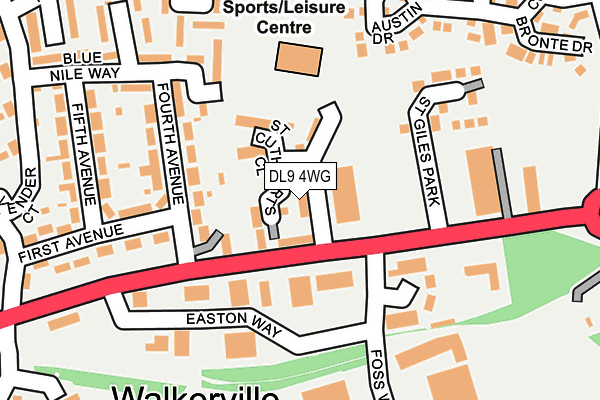
DL9 4WG is located in the Hipswell & Colburn electoral ward, within the unitary authority of North Yorkshire and the English Parliamentary constituency of Richmond (Yorks). The Sub Integrated Care Board (ICB) Location is NHS Humber and North Yorkshire ICB - 42D and the police force is North Yorkshire. This postcode has been in use since April 2017.


GetTheData
Source: OS OpenMap – Local (Ordnance Survey)
Source: OS VectorMap District (Ordnance Survey)
Licence: Open Government Licence (requires attribution)
| Easting | 420763 |
| Northing | 498357 |
| Latitude | 54.380301 |
| Longitude | -1.681848 |
GetTheData
Source: Open Postcode Geo
Licence: Open Government Licence
| Country | England |
| Postcode District | DL9 |
➜ See where DL9 is on a map ➜ Where is Catterick Garrison? | |
GetTheData
Source: Land Registry Price Paid Data
Licence: Open Government Licence
| Ward | Hipswell & Colburn |
| Constituency | Richmond (Yorks) |
GetTheData
Source: ONS Postcode Database
Licence: Open Government Licence
| Industrial Park (A6136) | Walkerville | 88m |
| Industrial Park (A6136) | Walkerville | 97m |
| Fifth Avenue (Blue Nile Way) | Colburn | 207m |
| Fifth Avenue (Blue Nile Way) | Colburn | 244m |
| Brough With St Giles (Churchill Drive) | Walkerville | 382m |
GetTheData
Source: NaPTAN
Licence: Open Government Licence
| Percentage of properties with Next Generation Access | 100.0% |
| Percentage of properties with Superfast Broadband | 100.0% |
| Percentage of properties with Ultrafast Broadband | 0.0% |
| Percentage of properties with Full Fibre Broadband | 0.0% |
Superfast Broadband is between 30Mbps and 300Mbps
Ultrafast Broadband is > 300Mbps
| Median download speed | 39.5Mbps |
| Average download speed | 33.3Mbps |
| Maximum download speed | 48.71Mbps |
| Median upload speed | 10.0Mbps |
| Average upload speed | 8.1Mbps |
| Maximum upload speed | 11.82Mbps |
| Percentage of properties unable to receive 2Mbps | 0.0% |
| Percentage of properties unable to receive 5Mbps | 0.0% |
| Percentage of properties unable to receive 10Mbps | 0.0% |
| Percentage of properties unable to receive 30Mbps | 0.0% |
GetTheData
Source: Ofcom
Licence: Ofcom Terms of Use (requires attribution)
GetTheData
Source: ONS Postcode Database
Licence: Open Government Licence


➜ Get more ratings from the Food Standards Agency
GetTheData
Source: Food Standards Agency
Licence: FSA terms & conditions
| Last Collection | |||
|---|---|---|---|
| Location | Mon-Fri | Sat | Distance |
| Vimy Barracks, Catterick Garris | 17:00 | 11:15 | 939m |
| Hilyard Row, Catterick Garrison | 17:00 | 11:00 | 1,783m |
| Bridge Road, Brompton On Swale | 17:00 | 11:30 | 1,828m |
GetTheData
Source: Dracos
Licence: Creative Commons Attribution-ShareAlike
The below table lists the International Territorial Level (ITL) codes (formerly Nomenclature of Territorial Units for Statistics (NUTS) codes) and Local Administrative Units (LAU) codes for DL9 4WG:
| ITL 1 Code | Name |
|---|---|
| TLE | Yorkshire and The Humber |
| ITL 2 Code | Name |
| TLE2 | North Yorkshire |
| ITL 3 Code | Name |
| TLE22 | North Yorkshire CC |
| LAU 1 Code | Name |
| E07000166 | Richmondshire |
GetTheData
Source: ONS Postcode Directory
Licence: Open Government Licence
The below table lists the Census Output Area (OA), Lower Layer Super Output Area (LSOA), and Middle Layer Super Output Area (MSOA) for DL9 4WG:
| Code | Name | |
|---|---|---|
| OA | E00141320 | |
| LSOA | E01027749 | Richmondshire 004A |
| MSOA | E02005785 | Richmondshire 004 |
GetTheData
Source: ONS Postcode Directory
Licence: Open Government Licence
| DL9 4RN | Fourth Avenue | 107m |
| DL9 4UN | Firefly Walk | 141m |
| DL9 4GA | Easton Way | 158m |
| DL9 4RL | First Avenue | 161m |
| DL9 4XA | St Giles Park | 162m |
| DL9 4UW | Blue Nile Way | 198m |
| DL9 4RT | Catterick Road | 204m |
| DL9 4UL | Watermint Way | 214m |
| DL9 4UJ | Thistle Walk | 223m |
| DL9 4RQ | First Avenue | 230m |
GetTheData
Source: Open Postcode Geo; Land Registry Price Paid Data
Licence: Open Government Licence