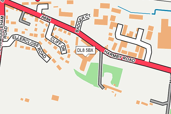
DL8 5BX is located in the Leyburn & Middleham electoral ward, within the unitary authority of North Yorkshire and the English Parliamentary constituency of Richmond (Yorks). The Sub Integrated Care Board (ICB) Location is NHS Humber and North Yorkshire ICB - 42D and the police force is North Yorkshire. This postcode has been in use since October 2016.


GetTheData
Source: OS OpenMap – Local (Ordnance Survey)
Source: OS VectorMap District (Ordnance Survey)
Licence: Open Government Licence (requires attribution)
| Easting | 411830 |
| Northing | 490094 |
| Latitude | 54.306325 |
| Longitude | -1.819702 |
GetTheData
Source: Open Postcode Geo
Licence: Open Government Licence
| Country | England |
| Postcode District | DL8 |
➜ See where DL8 is on a map ➜ Where is Leyburn? | |
GetTheData
Source: Land Registry Price Paid Data
Licence: Open Government Licence
Elevation or altitude of DL8 5BX as distance above sea level:
| Metres | Feet | |
|---|---|---|
| Elevation | 170m | 558ft |
Elevation is measured from the approximate centre of the postcode, to the nearest point on an OS contour line from OS Terrain 50, which has contour spacing of ten vertical metres.
➜ How high above sea level am I? Find the elevation of your current position using your device's GPS.
GetTheData
Source: Open Postcode Elevation
Licence: Open Government Licence
| Ward | Leyburn & Middleham |
| Constituency | Richmond (Yorks) |
GetTheData
Source: ONS Postcode Database
Licence: Open Government Licence
| Middleham Road (Harmby Road) | Leyburn | 360m |
| St Matthews Terr (Harmby Road) | Leyburn | 371m |
| Opp York Dales Park (A684) | Harmby | 418m |
| Yorks Dales Park (A684) | Harmby | 486m |
| Market Place (Railway Street) | Leyburn | 761m |
| Leyburn (Wensleydale Railway) | Leyburn | 220m |
GetTheData
Source: NaPTAN
Licence: Open Government Licence
| Median download speed | 33.9Mbps |
| Average download speed | 37.1Mbps |
| Maximum download speed | 80.00Mbps |
| Median upload speed | 5.6Mbps |
| Average upload speed | 7.0Mbps |
| Maximum upload speed | 20.00Mbps |
GetTheData
Source: Ofcom
Licence: Ofcom Terms of Use (requires attribution)
GetTheData
Source: ONS Postcode Database
Licence: Open Government Licence


➜ Get more ratings from the Food Standards Agency
GetTheData
Source: Food Standards Agency
Licence: FSA terms & conditions
| Last Collection | |||
|---|---|---|---|
| Location | Mon-Fri | Sat | Distance |
| The Busks, Middleham | 17:15 | 11:45 | 2,148m |
| Park Lane Estate, Middleham | 17:15 | 12:00 | 2,454m |
| Middleham | 17:30 | 12:00 | 2,487m |
GetTheData
Source: Dracos
Licence: Creative Commons Attribution-ShareAlike
The below table lists the International Territorial Level (ITL) codes (formerly Nomenclature of Territorial Units for Statistics (NUTS) codes) and Local Administrative Units (LAU) codes for DL8 5BX:
| ITL 1 Code | Name |
|---|---|
| TLE | Yorkshire and The Humber |
| ITL 2 Code | Name |
| TLE2 | North Yorkshire |
| ITL 3 Code | Name |
| TLE22 | North Yorkshire CC |
| LAU 1 Code | Name |
| E07000166 | Richmondshire |
GetTheData
Source: ONS Postcode Directory
Licence: Open Government Licence
The below table lists the Census Output Area (OA), Lower Layer Super Output Area (LSOA), and Middle Layer Super Output Area (MSOA) for DL8 5BX:
| Code | Name | |
|---|---|---|
| OA | E00141358 | |
| LSOA | E01033186 | Richmondshire 006G |
| MSOA | E02005787 | Richmondshire 006 |
GetTheData
Source: ONS Postcode Directory
Licence: Open Government Licence
| DL8 5EX | Cliff Drive | 123m |
| DL8 5QA | Leyburn Business Park | 169m |
| DL8 5EZ | Ellerclose Road | 187m |
| DL8 5ET | Harmby Road | 242m |
| DL8 5EU | Harmby Road | 263m |
| DL8 5EY | Middleham Road | 302m |
| DL8 5HA | Middleham Road | 345m |
| DL8 5ES | South View | 350m |
| DL8 5HW | Brentwood | 372m |
| DL8 5HT | Brentwood | 400m |
GetTheData
Source: Open Postcode Geo; Land Registry Price Paid Data
Licence: Open Government Licence