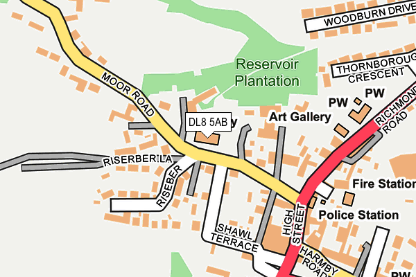
DL8 5AB is located in the Leyburn & Middleham electoral ward, within the unitary authority of North Yorkshire and the English Parliamentary constituency of Richmond (Yorks). The Sub Integrated Care Board (ICB) Location is NHS Humber and North Yorkshire ICB - 42D and the police force is North Yorkshire. This postcode has been in use since December 2000.


GetTheData
Source: OS OpenMap – Local (Ordnance Survey)
Source: OS VectorMap District (Ordnance Survey)
Licence: Open Government Licence (requires attribution)
| Easting | 411010 |
| Northing | 490684 |
| Latitude | 54.311635 |
| Longitude | -1.832277 |
GetTheData
Source: Open Postcode Geo
Licence: Open Government Licence
| Country | England |
| Postcode District | DL8 |
➜ See where DL8 is on a map ➜ Where is Leyburn? | |
GetTheData
Source: Land Registry Price Paid Data
Licence: Open Government Licence
Elevation or altitude of DL8 5AB as distance above sea level:
| Metres | Feet | |
|---|---|---|
| Elevation | 210m | 689ft |
Elevation is measured from the approximate centre of the postcode, to the nearest point on an OS contour line from OS Terrain 50, which has contour spacing of ten vertical metres.
➜ How high above sea level am I? Find the elevation of your current position using your device's GPS.
GetTheData
Source: Open Postcode Elevation
Licence: Open Government Licence
| Ward | Leyburn & Middleham |
| Constituency | Richmond (Yorks) |
GetTheData
Source: ONS Postcode Database
Licence: Open Government Licence
| Market Place (Railway Street) | Leyburn | 264m |
| Wenslydale School (Richmond Road) | Leyburn | 352m |
| Wenslydale School (Richmond Road) | Leyburn | 371m |
| St Matthews Terr (Harmby Road) | Leyburn | 639m |
| Middleham Road (Harmby Road) | Leyburn | 651m |
| Leyburn (Wensleydale Railway) | Leyburn | 843m |
GetTheData
Source: NaPTAN
Licence: Open Government Licence
GetTheData
Source: ONS Postcode Database
Licence: Open Government Licence


➜ Get more ratings from the Food Standards Agency
GetTheData
Source: Food Standards Agency
Licence: FSA terms & conditions
| Last Collection | |||
|---|---|---|---|
| Location | Mon-Fri | Sat | Distance |
| Bellerby | 17:45 | 12:30 | 2,237m |
| The Busks, Middleham | 17:15 | 11:45 | 3,034m |
| Park Lane Estate, Middleham | 17:15 | 12:00 | 3,306m |
GetTheData
Source: Dracos
Licence: Creative Commons Attribution-ShareAlike
The below table lists the International Territorial Level (ITL) codes (formerly Nomenclature of Territorial Units for Statistics (NUTS) codes) and Local Administrative Units (LAU) codes for DL8 5AB:
| ITL 1 Code | Name |
|---|---|
| TLE | Yorkshire and The Humber |
| ITL 2 Code | Name |
| TLE2 | North Yorkshire |
| ITL 3 Code | Name |
| TLE22 | North Yorkshire CC |
| LAU 1 Code | Name |
| E07000166 | Richmondshire |
GetTheData
Source: ONS Postcode Directory
Licence: Open Government Licence
The below table lists the Census Output Area (OA), Lower Layer Super Output Area (LSOA), and Middle Layer Super Output Area (MSOA) for DL8 5AB:
| Code | Name | |
|---|---|---|
| OA | E00141356 | |
| LSOA | E01033185 | Richmondshire 006F |
| MSOA | E02005787 | Richmondshire 006 |
GetTheData
Source: ONS Postcode Directory
Licence: Open Government Licence
| DL8 5DE | Moor Road | 44m |
| DL8 5AD | Moor Road | 67m |
| DL8 5SU | Yew Tree Close | 86m |
| DL8 5DF | Riseber | 105m |
| DL8 5AG | Grove Square | 122m |
| DL8 5AE | Grove Square | 123m |
| DL8 5DD | Manor Court | 124m |
| DL8 5DZ | Smithy Lane | 132m |
| DL8 5DQ | Riseber Lane | 137m |
| DL8 5DA | Shawl Terrace | 140m |
GetTheData
Source: Open Postcode Geo; Land Registry Price Paid Data
Licence: Open Government Licence