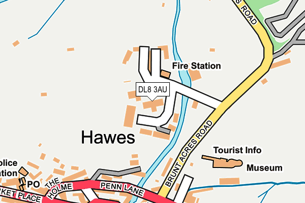
DL8 3AU is located in the Upper Dales electoral ward, within the unitary authority of North Yorkshire and the English Parliamentary constituency of Richmond (Yorks). The Sub Integrated Care Board (ICB) Location is NHS Humber and North Yorkshire ICB - 42D and the police force is North Yorkshire. This postcode has been in use since November 2010.


GetTheData
Source: OS OpenMap – Local (Ordnance Survey)
Source: OS VectorMap District (Ordnance Survey)
Licence: Open Government Licence (requires attribution)
| Easting | 387451 |
| Northing | 490023 |
| Latitude | 54.305653 |
| Longitude | -2.194355 |
GetTheData
Source: Open Postcode Geo
Licence: Open Government Licence
| Country | England |
| Postcode District | DL8 |
➜ See where DL8 is on a map ➜ Where is Hawes? | |
GetTheData
Source: Land Registry Price Paid Data
Licence: Open Government Licence
Elevation or altitude of DL8 3AU as distance above sea level:
| Metres | Feet | |
|---|---|---|
| Elevation | 230m | 755ft |
Elevation is measured from the approximate centre of the postcode, to the nearest point on an OS contour line from OS Terrain 50, which has contour spacing of ten vertical metres.
➜ How high above sea level am I? Find the elevation of your current position using your device's GPS.
GetTheData
Source: Open Postcode Elevation
Licence: Open Government Licence
| Ward | Upper Dales |
| Constituency | Richmond (Yorks) |
GetTheData
Source: ONS Postcode Database
Licence: Open Government Licence
| Penn Lane (A684) | Hawes | 172m |
| Dales Countryside Museum (Brunt Acres Road) | Hawes | 174m |
| Post Office (A684) | Hawes | 232m |
| Market Place (Turfy Hill) | Hawes | 349m |
| Market Place (Turfy Hill) | Hawes | 361m |
GetTheData
Source: NaPTAN
Licence: Open Government Licence
GetTheData
Source: ONS Postcode Database
Licence: Open Government Licence


➜ Get more ratings from the Food Standards Agency
GetTheData
Source: Food Standards Agency
Licence: FSA terms & conditions
| Last Collection | |||
|---|---|---|---|
| Location | Mon-Fri | Sat | Distance |
| Hawes | 16:45 | 11:00 | 230m |
| Market Place, Hawes | 16:30 | 11:00 | 357m |
| Stonehouse | 16:15 | 08:15 | 1,021m |
GetTheData
Source: Dracos
Licence: Creative Commons Attribution-ShareAlike
| Risk of DL8 3AU flooding from rivers and sea | Medium |
| ➜ DL8 3AU flood map | |
GetTheData
Source: Open Flood Risk by Postcode
Licence: Open Government Licence
The below table lists the International Territorial Level (ITL) codes (formerly Nomenclature of Territorial Units for Statistics (NUTS) codes) and Local Administrative Units (LAU) codes for DL8 3AU:
| ITL 1 Code | Name |
|---|---|
| TLE | Yorkshire and The Humber |
| ITL 2 Code | Name |
| TLE2 | North Yorkshire |
| ITL 3 Code | Name |
| TLE22 | North Yorkshire CC |
| LAU 1 Code | Name |
| E07000166 | Richmondshire |
GetTheData
Source: ONS Postcode Directory
Licence: Open Government Licence
The below table lists the Census Output Area (OA), Lower Layer Super Output Area (LSOA), and Middle Layer Super Output Area (MSOA) for DL8 3AU:
| Code | Name | |
|---|---|---|
| OA | E00141337 | |
| LSOA | E01027753 | Richmondshire 005B |
| MSOA | E02005786 | Richmondshire 005 |
GetTheData
Source: ONS Postcode Directory
Licence: Open Government Licence
| DL8 3UZ | Upper Wensley Dale Business Park | 64m |
| DL8 3QT | Ings Houses | 125m |
| DL8 3QA | Hardrow Road | 130m |
| DL8 3QU | 191m | |
| DL8 3NL | Town Foot | 201m |
| DL8 3QL | Main Street | 229m |
| DL8 3QX | Market Place | 229m |
| DL8 3QR | The Holme | 232m |
| DL8 3NH | Town Foot | 237m |
| DL8 3QW | Main Street | 241m |
GetTheData
Source: Open Postcode Geo; Land Registry Price Paid Data
Licence: Open Government Licence