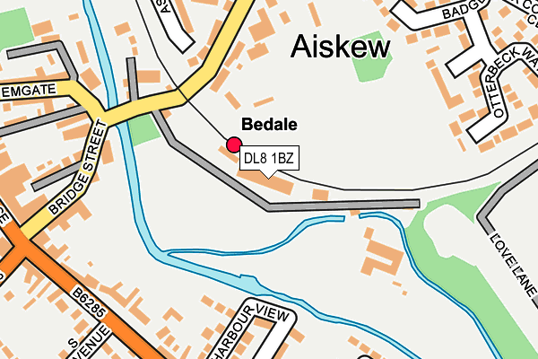
DL8 1BZ is located in the Aiskew & Leeming electoral ward, within the unitary authority of North Yorkshire and the English Parliamentary constituency of Richmond (Yorks). The Sub Integrated Care Board (ICB) Location is NHS Humber and North Yorkshire ICB - 42D and the police force is North Yorkshire. This postcode has been in use since April 2006.


GetTheData
Source: OS OpenMap – Local (Ordnance Survey)
Source: OS VectorMap District (Ordnance Survey)
Licence: Open Government Licence (requires attribution)
| Easting | 426966 |
| Northing | 488204 |
| Latitude | 54.288757 |
| Longitude | -1.587257 |
GetTheData
Source: Open Postcode Geo
Licence: Open Government Licence
| Country | England |
| Postcode District | DL8 |
➜ See where DL8 is on a map ➜ Where is Bedale? | |
GetTheData
Source: Land Registry Price Paid Data
Licence: Open Government Licence
Elevation or altitude of DL8 1BZ as distance above sea level:
| Metres | Feet | |
|---|---|---|
| Elevation | 40m | 131ft |
Elevation is measured from the approximate centre of the postcode, to the nearest point on an OS contour line from OS Terrain 50, which has contour spacing of ten vertical metres.
➜ How high above sea level am I? Find the elevation of your current position using your device's GPS.
GetTheData
Source: Open Postcode Elevation
Licence: Open Government Licence
| Ward | Aiskew & Leeming |
| Constituency | Richmond (Yorks) |
GetTheData
Source: ONS Postcode Database
Licence: Open Government Licence
| Eccles Heddon Solicitors (B6285) | Bedale | 269m |
| St Mary & St Josephs Church (A684) | Aiskew | 276m |
| St Mary & St Josephs Church (A684) | Aiskew | 299m |
| Market Place (B6285) | Bedale | 322m |
| Fitzalan Road | Bedale | 389m |
| Bedale (Wensleydale Railway) | Bedale | 42m |
GetTheData
Source: NaPTAN
Licence: Open Government Licence
GetTheData
Source: ONS Postcode Database
Licence: Open Government Licence


➜ Get more ratings from the Food Standards Agency
GetTheData
Source: Food Standards Agency
Licence: FSA terms & conditions
| Last Collection | |||
|---|---|---|---|
| Location | Mon-Fri | Sat | Distance |
| Masham Road | 17:30 | 11:40 | 852m |
| Rigby Terrace | 16:45 | 11:30 | 911m |
| Londonderry | 16:00 | 09:00 | 3,349m |
GetTheData
Source: Dracos
Licence: Creative Commons Attribution-ShareAlike
The below table lists the International Territorial Level (ITL) codes (formerly Nomenclature of Territorial Units for Statistics (NUTS) codes) and Local Administrative Units (LAU) codes for DL8 1BZ:
| ITL 1 Code | Name |
|---|---|
| TLE | Yorkshire and The Humber |
| ITL 2 Code | Name |
| TLE2 | North Yorkshire |
| ITL 3 Code | Name |
| TLE22 | North Yorkshire CC |
| LAU 1 Code | Name |
| E07000164 | Hambleton |
GetTheData
Source: ONS Postcode Directory
Licence: Open Government Licence
The below table lists the Census Output Area (OA), Lower Layer Super Output Area (LSOA), and Middle Layer Super Output Area (MSOA) for DL8 1BZ:
| Code | Name | |
|---|---|---|
| OA | E00140445 | |
| LSOA | E01027589 | Hambleton 006C |
| MSOA | E02005755 | Hambleton 006 |
GetTheData
Source: ONS Postcode Directory
Licence: Open Government Licence
| DL8 1AW | The Bridge | 125m |
| DL8 1AS | Aiskew Bank | 153m |
| DL8 1AN | The Bridge | 181m |
| DL8 2DQ | Harbour View | 191m |
| DL8 2DA | Victoria Terrace | 211m |
| DL8 2AB | The Villas | 224m |
| DL8 2AD | Bridge Street | 228m |
| DL8 2DD | Barras Terrace | 228m |
| DL8 1FA | Emgate | 232m |
| DL8 2AR | Hawthorn Lane | 241m |
GetTheData
Source: Open Postcode Geo; Land Registry Price Paid Data
Licence: Open Government Licence