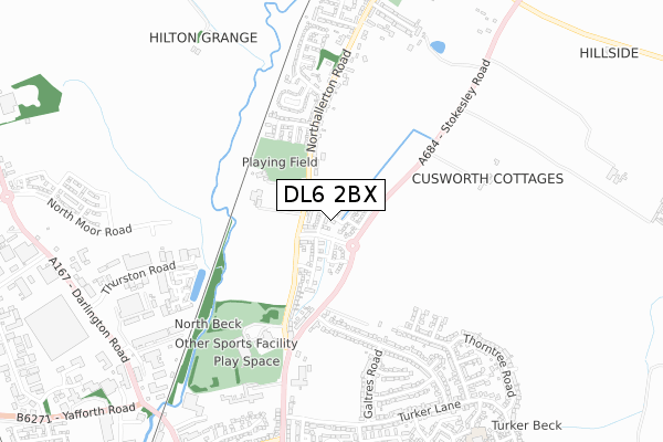
DL6 2BX is located in the Northallerton North & Brompton electoral ward, within the unitary authority of North Yorkshire and the English Parliamentary constituency of Richmond (Yorks). The Sub Integrated Care Board (ICB) Location is NHS Humber and North Yorkshire ICB - 42D and the police force is North Yorkshire. This postcode has been in use since June 2019.


GetTheData
Source: OS Open Zoomstack (Ordnance Survey)
Licence: Open Government Licence (requires attribution)
Attribution: Contains OS data © Crown copyright and database right 2025
Source: Open Postcode Geo
Licence: Open Government Licence (requires attribution)
Attribution: Contains OS data © Crown copyright and database right 2025; Contains Royal Mail data © Royal Mail copyright and database right 2025; Source: Office for National Statistics licensed under the Open Government Licence v.3.0
| Easting | 437248 |
| Northing | 495346 |
| Latitude | 54.352309 |
| Longitude | -1.428437 |
GetTheData
Source: Open Postcode Geo
Licence: Open Government Licence
| Country | England |
| Postcode District | DL6 |
➜ See where DL6 is on a map ➜ Where is Northallerton? | |
GetTheData
Source: Land Registry Price Paid Data
Licence: Open Government Licence
| Ward | Northallerton North & Brompton |
| Constituency | Richmond (Yorks) |
GetTheData
Source: ONS Postcode Database
Licence: Open Government Licence
18, COTSWOLD STREET, BROMPTON, NORTHALLERTON, DL6 2BX 2024 27 JUN £435,000 |
4, COTSWOLD STREET, BROMPTON, NORTHALLERTON, DL6 2BX 2024 4 APR £280,000 |
6, COTSWOLD STREET, BROMPTON, NORTHALLERTON, DL6 2BX 2023 14 APR £130,000 |
30, COTSWOLD STREET, BROMPTON, NORTHALLERTON, DL6 2BX 2021 11 MAR £337,950 |
69, COTSWOLD STREET, BROMPTON, NORTHALLERTON, DL6 2BX 2021 26 FEB £295,950 |
51, COTSWOLD STREET, BROMPTON, NORTHALLERTON, DL6 2BX 2021 22 FEB £349,950 |
10, COTSWOLD STREET, BROMPTON, NORTHALLERTON, DL6 2BX 2021 10 FEB £299,000 |
71, COTSWOLD STREET, BROMPTON, NORTHALLERTON, DL6 2BX 2021 15 JAN £278,950 |
65, COTSWOLD STREET, BROMPTON, NORTHALLERTON, DL6 2BX 2020 11 DEC £227,950 |
67, COTSWOLD STREET, BROMPTON, NORTHALLERTON, DL6 2BX 2020 8 DEC £232,950 |
GetTheData
Source: HM Land Registry Price Paid Data
Licence: Contains HM Land Registry data © Crown copyright and database right 2025. This data is licensed under the Open Government Licence v3.0.
| De Bruce Road (Northallerton Road) | Brompton | 320m |
| De Bruce Road (Northallerton Road) | Brompton | 360m |
| Stone Cross (Northallerton Road) | Northallerton | 409m |
| Stone Cross (Northallerton Road) | Northallerton | 442m |
| Hilton Close (Northallerton Road) | Brompton | 524m |
| Northallerton Station | 2.3km |
GetTheData
Source: NaPTAN
Licence: Open Government Licence
| Percentage of properties with Next Generation Access | 100.0% |
| Percentage of properties with Superfast Broadband | 100.0% |
| Percentage of properties with Ultrafast Broadband | 85.0% |
| Percentage of properties with Full Fibre Broadband | 85.0% |
Superfast Broadband is between 30Mbps and 300Mbps
Ultrafast Broadband is > 300Mbps
| Percentage of properties unable to receive 2Mbps | 0.0% |
| Percentage of properties unable to receive 5Mbps | 0.0% |
| Percentage of properties unable to receive 10Mbps | 0.0% |
| Percentage of properties unable to receive 30Mbps | 0.0% |
GetTheData
Source: Ofcom
Licence: Ofcom Terms of Use (requires attribution)
GetTheData
Source: ONS Postcode Database
Licence: Open Government Licence


➜ Get more ratings from the Food Standards Agency
GetTheData
Source: Food Standards Agency
Licence: FSA terms & conditions
| Last Collection | |||
|---|---|---|---|
| Location | Mon-Fri | Sat | Distance |
| Brompton Road | 17:30 | 10:00 | 364m |
| Quaker Lane | 17:30 | 11:15 | 779m |
| Thurston Road | 828m | ||
GetTheData
Source: Dracos
Licence: Creative Commons Attribution-ShareAlike
The below table lists the International Territorial Level (ITL) codes (formerly Nomenclature of Territorial Units for Statistics (NUTS) codes) and Local Administrative Units (LAU) codes for DL6 2BX:
| ITL 1 Code | Name |
|---|---|
| TLE | Yorkshire and The Humber |
| ITL 2 Code | Name |
| TLE2 | North Yorkshire |
| ITL 3 Code | Name |
| TLE22 | North Yorkshire CC |
| LAU 1 Code | Name |
| E07000164 | Hambleton |
GetTheData
Source: ONS Postcode Directory
Licence: Open Government Licence
The below table lists the Census Output Area (OA), Lower Layer Super Output Area (LSOA), and Middle Layer Super Output Area (MSOA) for DL6 2BX:
| Code | Name | |
|---|---|---|
| OA | E00140587 | |
| LSOA | E01027611 | Hambleton 004F |
| MSOA | E02005753 | Hambleton 004 |
GetTheData
Source: ONS Postcode Directory
Licence: Open Government Licence
| DL6 2QD | De Gaunte Road | 366m |
| DL6 2PY | Northallerton Road | 391m |
| DL6 2QB | Northallerton Road | 398m |
| DL6 2TS | Stokesley Road | 400m |
| DL6 2QA | Northallerton Road | 434m |
| DL6 2QF | De Ferrers Road | 440m |
| DL6 2QE | De Bruce Road | 451m |
| DL6 1RG | Winton Road | 501m |
| DL6 1QT | Mowbray Road | 508m |
| DL6 2QG | Hilton Green | 515m |
GetTheData
Source: Open Postcode Geo; Land Registry Price Paid Data
Licence: Open Government Licence