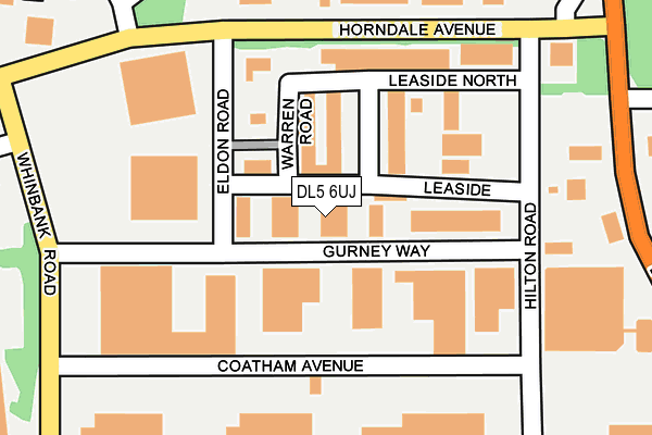
DL5 6UJ is located in the Aycliffe East electoral ward, within the unitary authority of County Durham and the English Parliamentary constituency of Sedgefield. The Sub Integrated Care Board (ICB) Location is NHS North East and North Cumbria ICB - 84H and the police force is Durham. This postcode has been in use since September 1991.


GetTheData
Source: OS OpenMap – Local (Ordnance Survey)
Source: OS VectorMap District (Ordnance Survey)
Licence: Open Government Licence (requires attribution)
| Easting | 427647 |
| Northing | 523872 |
| Latitude | 54.609270 |
| Longitude | -1.573490 |
GetTheData
Source: Open Postcode Geo
Licence: Open Government Licence
| Country | England |
| Postcode District | DL5 |
➜ See where DL5 is on a map ➜ Where is Newton Aycliffe? | |
GetTheData
Source: Land Registry Price Paid Data
Licence: Open Government Licence
Elevation or altitude of DL5 6UJ as distance above sea level:
| Metres | Feet | |
|---|---|---|
| Elevation | 90m | 295ft |
Elevation is measured from the approximate centre of the postcode, to the nearest point on an OS contour line from OS Terrain 50, which has contour spacing of ten vertical metres.
➜ How high above sea level am I? Find the elevation of your current position using your device's GPS.
GetTheData
Source: Open Postcode Elevation
Licence: Open Government Licence
| Ward | Aycliffe East |
| Constituency | Sedgefield |
GetTheData
Source: ONS Postcode Database
Licence: Open Government Licence
| Groat Avenue (St Cuthberts Way) | Newton Aycliffe | 286m |
| Groat Avenue (St Cuthberts Way) | Newton Aycliffe | 287m |
| North East Gate (St Cuthberts Way) | Newton Aycliffe | 431m |
| Finchale Road | Newton Aycliffe | 448m |
| Finchale Road | Newton Aycliffe | 460m |
| Newton Aycliffe Station | 1.2km |
| Heighington Station | 1.5km |
| Shildon Station | 4.5km |
GetTheData
Source: NaPTAN
Licence: Open Government Licence
Estimated total energy consumption in DL5 6UJ by fuel type, 2015.
| Consumption (kWh) | 118,681 |
|---|---|
| Meter count | 10 |
| Mean (kWh/meter) | 11,868 |
| Median (kWh/meter) | 1,208 |
GetTheData
Source: Postcode level gas estimates: 2015 (experimental)
Source: Postcode level electricity estimates: 2015 (experimental)
Licence: Open Government Licence
GetTheData
Source: ONS Postcode Database
Licence: Open Government Licence


➜ Get more ratings from the Food Standards Agency
GetTheData
Source: Food Standards Agency
Licence: FSA terms & conditions
| Last Collection | |||
|---|---|---|---|
| Location | Mon-Fri | Sat | Distance |
| Beveridge Way | 17:30 | 12:00 | 511m |
| Burn Lane | 16:45 | 11:15 | 1,563m |
| Garburn Place | 16:45 | 10:45 | 1,894m |
GetTheData
Source: Dracos
Licence: Creative Commons Attribution-ShareAlike
The below table lists the International Territorial Level (ITL) codes (formerly Nomenclature of Territorial Units for Statistics (NUTS) codes) and Local Administrative Units (LAU) codes for DL5 6UJ:
| ITL 1 Code | Name |
|---|---|
| TLC | North East (England) |
| ITL 2 Code | Name |
| TLC1 | Tees Valley and Durham |
| ITL 3 Code | Name |
| TLC14 | Durham |
| LAU 1 Code | Name |
| E06000047 | County Durham |
GetTheData
Source: ONS Postcode Directory
Licence: Open Government Licence
The below table lists the Census Output Area (OA), Lower Layer Super Output Area (LSOA), and Middle Layer Super Output Area (MSOA) for DL5 6UJ:
| Code | Name | |
|---|---|---|
| OA | E00105680 | |
| LSOA | E01020826 | County Durham 063B |
| MSOA | E02004344 | County Durham 063 |
GetTheData
Source: ONS Postcode Directory
Licence: Open Government Licence
| DL5 6HX | Leaside | 88m |
| DL5 6DE | Leaside | 100m |
| DL5 6DU | Leaside North | 121m |
| DL5 6EN | Hilton Road | 242m |
| DL5 6DR | Horndale Avenue | 247m |
| DL5 6DS | Horndale Avenue | 332m |
| DL5 5HT | Finchale Road | 433m |
| DL5 5HR | Wilson Walk | 478m |
| DL5 5HJ | Moule Close | 479m |
| DL5 5HP | Hopper Road | 482m |
GetTheData
Source: Open Postcode Geo; Land Registry Price Paid Data
Licence: Open Government Licence