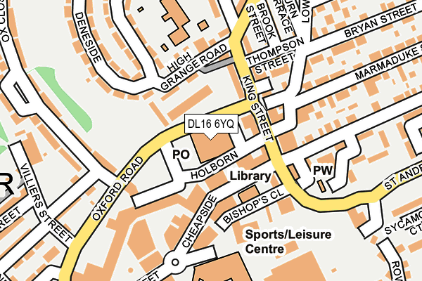
DL16 6YQ is located in the Tudhoe electoral ward, within the unitary authority of County Durham and the English Parliamentary constituency of Bishop Auckland. The Sub Integrated Care Board (ICB) Location is NHS North East and North Cumbria ICB - 84H and the police force is Durham. This postcode has been in use since January 1983.


GetTheData
Source: OS OpenMap – Local (Ordnance Survey)
Source: OS VectorMap District (Ordnance Survey)
Licence: Open Government Licence (requires attribution)
| Easting | 425885 |
| Northing | 534070 |
| Latitude | 54.700997 |
| Longitude | -1.599860 |
GetTheData
Source: Open Postcode Geo
Licence: Open Government Licence
| Country | England |
| Postcode District | DL16 |
➜ See where DL16 is on a map ➜ Where is Spennymoor? | |
GetTheData
Source: Land Registry Price Paid Data
Licence: Open Government Licence
Elevation or altitude of DL16 6YQ as distance above sea level:
| Metres | Feet | |
|---|---|---|
| Elevation | 110m | 361ft |
Elevation is measured from the approximate centre of the postcode, to the nearest point on an OS contour line from OS Terrain 50, which has contour spacing of ten vertical metres.
➜ How high above sea level am I? Find the elevation of your current position using your device's GPS.
GetTheData
Source: Open Postcode Elevation
Licence: Open Government Licence
| Ward | Tudhoe |
| Constituency | Bishop Auckland |
GetTheData
Source: ONS Postcode Database
Licence: Open Government Licence
| Cheapside Stand C (Cheapside) | Spennymoor | 74m |
| Cheapside Stand B (Cheapside) | Spennymoor | 81m |
| Cheapside Stand F (Cheapside) | Spennymoor | 82m |
| Asda Store Front (Store Carpark) | Spennymoor | 227m |
| Burn Terrace (Durham Road) | Spennymoor | 245m |
| Bishop Auckland Station | 7km |
GetTheData
Source: NaPTAN
Licence: Open Government Licence
GetTheData
Source: ONS Postcode Database
Licence: Open Government Licence


➜ Get more ratings from the Food Standards Agency
GetTheData
Source: Food Standards Agency
Licence: FSA terms & conditions
| Last Collection | |||
|---|---|---|---|
| Location | Mon-Fri | Sat | Distance |
| Post Office | 17:15 | 11:30 | 23m |
| Co Op, Holborn Street | 18:30 | 11:30 | 26m |
| King Street | 17:00 | 11:00 | 102m |
GetTheData
Source: Dracos
Licence: Creative Commons Attribution-ShareAlike
The below table lists the International Territorial Level (ITL) codes (formerly Nomenclature of Territorial Units for Statistics (NUTS) codes) and Local Administrative Units (LAU) codes for DL16 6YQ:
| ITL 1 Code | Name |
|---|---|
| TLC | North East (England) |
| ITL 2 Code | Name |
| TLC1 | Tees Valley and Durham |
| ITL 3 Code | Name |
| TLC14 | Durham |
| LAU 1 Code | Name |
| E06000047 | County Durham |
GetTheData
Source: ONS Postcode Directory
Licence: Open Government Licence
The below table lists the Census Output Area (OA), Lower Layer Super Output Area (LSOA), and Middle Layer Super Output Area (MSOA) for DL16 6YQ:
| Code | Name | |
|---|---|---|
| OA | E00105643 | |
| LSOA | E01020820 | County Durham 049C |
| MSOA | E02004335 | County Durham 049 |
GetTheData
Source: ONS Postcode Directory
Licence: Open Government Licence
| DL16 6QN | Holborn Street | 45m |
| DL16 6QF | Cheapside | 57m |
| DL16 6QQ | King Street | 65m |
| DL16 6QH | King Street | 95m |
| DL16 6QG | King Street | 104m |
| DL16 6QP | King Street | 105m |
| DL16 6QE | Cheapside | 120m |
| DL16 6RA | High Grange Road | 129m |
| DL16 6RY | Ohanlan Street | 132m |
| DL16 6FJ | Bishops Close | 140m |
GetTheData
Source: Open Postcode Geo; Land Registry Price Paid Data
Licence: Open Government Licence